dimanche 31 mars 2013
Nevreme Melenci 31.03.2013. (3. deo)
http://www.youtube.com/watch?feature=player_embedded&v=-S23vOKjaSw
European Storm Forecast Experiment
Storm Forecast
Storm Forecast
Valid: Mon 01 Apr 2013 06:00 to Tue 02 Apr 2013 06:00 UTC
Issued: Sun 31 Mar 2013 22:34
Forecaster: TUSCHY
A level 1 was issued for S-Portugal mainly for an isolated large hail event.Valid: Mon 01 Apr 2013 06:00 to Tue 02 Apr 2013 06:00 UTC
Issued: Sun 31 Mar 2013 22:34
Forecaster: TUSCHY
A level 1 was issued for NE-Algeria and N-Tunisia mainly for a few large hail and severe wind gust events.
A level 1 was issued for W-Turkey mainly for a few large hail events.
A level 1 was issued for the far NW-Mediterranean mainly for heavy rain and an isolated tornado/marine waterspout event.
Exclusive Video of Disastrous Flood in Mauritius 30 March 2013
https://www.youtube.com/watch?v=dOLzWFjn97s
Northern Lights (Aurora Borealis) Timelapse -- March 29, 2013
http://www.youtube.com/watch?v=2TAuqSoFzNU
First Spring 2013 Chase! March 29th Hail of a Supercell in North Texas
http://www.youtube.com/watch?v=9fH-Axnevtg


European Storm Forecast Experiment
Storm Forecast
Storm Forecast
Valid: Sun 31 Mar 2013 06:00 to Mon 01 Apr 2013 06:00 UTC
Issued: Sun 31 Mar 2013 07:32
Forecaster: VAN DER VELDE
A level 1 was issued for parts of Hungary, Romania,
Serbia mainly for a chance of large hail, tornadoes and severe
convective gusts.Valid: Sun 31 Mar 2013 06:00 to Mon 01 Apr 2013 06:00 UTC
Issued: Sun 31 Mar 2013 07:32
Forecaster: VAN DER VELDE
A level 1 was issued for the southwestern Balkan mainly for large hail.
A level 1 was issued for Portugal and western Spain mainly for chance of tornadoes.
samedi 30 mars 2013
Central Oklahoma Supercall and Hailstorm! - March 29, 2013
https://www.youtube.com/watch?v=-tzx_ISu2Xo
Really unusual weather - snowy 29th March 2013 - Slovakia, Banská Bystrica.
https://www.youtube.com/watch?v=UN3RFpUjXuc
vendredi 29 mars 2013
http://daviddrummond.com/live-chasecam.html
Chaser : David Drummond ,live now,south east of Lubbock,Texas
http://www.meteomedia.com/news/storm_watch_stories3&stormfile=Des_Qu_b_cois___la_conqu_te_des_tornades_28_03_2013?ref=ccbox_homepage_topstories
Des Québécois à la conquête des tornades
MétéoMédia
28 mars 2013 —
(18h45) Les chasseurs de tempêtes québécois Mathieu Bordage et Mathieu
Lussier partent en direction des États-Unis, où ils iront dans la région
que l'on surnomme l'allée des tornades. Mr Bordage et Mr Lussier, Bonne chasse,soyez prudent...

http://www.spc.noaa.gov/climo/reports/today.html

| Tornado Reports (CSV) (Raw Tornado CSV)(?) | |||||||
|---|---|---|---|---|---|---|---|
| Time | Location | County | State | Lat | Lon | Comments | |
| 2257 | 10 SW SUTHERLAND | LINCOLN | NE | 4106 | 10126 | PUBLIC REPORT RELAYED VIA LAW ENFORCEMENT (LBF) | |
| 2259 | 6 SW SUTHERLAND | LINCOLN | NE | 4110 | 10121 | SIGHTED 3 MILES WEST OF THE SUTHERLAND POWER PLANT. PUBLIC REPORT RELAYED VIA LAW ENFORCEMENT. (LBF) | |
| 2302 | 6 S SUTHERLAND | LINCOLN | NE | 4107 | 10113 | DEBRIS CLOUD VISIBLE 2 MILES SOUTH OF THE SUTHERLAND POWERPLANT (LBF) | |
European Storm Forecast Experiment
Storm Forecast
Storm Forecast
Valid: Fri 29 Mar 2013 06:00 to Sat 30 Mar 2013 06:00 UTC
Issued: Fri 29 Mar 2013 00:09
Forecaster: TUSCHY
A level 1 was issued for parts of Portugal and Spain
mainly for an isolated large hail, a strong to severe wind gust event
and an isolated tornado.
Valid: Fri 29 Mar 2013 06:00 to Sat 30 Mar 2013 06:00 UTC
Issued: Fri 29 Mar 2013 00:09
Forecaster: TUSCHY
jeudi 28 mars 2013
| Convective Outlooks | |
|---|---|
| This is today's convective outlook valid from 1Z to 12Z for organized severe thunderstorms over the contiguous United States. Please read the description of the risk categories for further information. You may find the Day 1 Outlook available as well as all Outlooks issued today online. | Day 1 Outlook Valid till 12Z |
|
|
| This is today's forecast for organized severe thunderstorms over the contiguous United States. Please read the description of the risk categories for further information. You may find the latest Day 1 Outlook available as well as all Outlooks issued today online. | Today's Outlook |

|
|
| This is tomorrow's forecast for organized severe thunderstorms over the contiguous United States. Please read the description of the risk categories for further information. The latest Day 2 Outlook is available as well as all Outlooks that have been issued today. | Tomorrow's Outlook |

|
|
| This is the day after tomorrow's (day 3) forecast for organized severe thunderstorms over the contiguous United States. Please read the description of the risk categories for further information. The latest Day 3 Outlook is available as well as all Outlooks that have been issued today. Note: The 10% and greater probability thunder line is not included on the Day 3 Outlook. | Day 3 Outlook |

|
|
| This is the day 4-8 forecast for organized severe thunderstorms over the contiguous United States. The latest Day 4-8 Outlook is available as well as all Outlooks that have been issued today. Note: A severe weather area depicted in the Day 4-8 period indicates a 30% or higher probability for severe thunderstorms (e.g. a 30% chance that a severe thunderstorm will occur within 25 miles of any point). | Day 4-8 Outlook |

| |
mercredi 27 mars 2013
Earthquake Mexico City- 5.5 Quake Sparks Panic as Buildings Sway in Capital City
https://www.youtube.com/watch?v=nn3QaGTQGzM
Taiwan Strong quake collapses walls. Puissant séisme secoue les murs. Terremoto pr
https://www.youtube.com/watch?v=WsdQRUI0RI0
European Storm Forecast Experiment
Storm Forecast
Storm Forecast
Valid: Thu 28 Mar 2013 06:00 to Fri 29 Mar 2013 06:00 UTC
Issued: Wed 27 Mar 2013 23:39
Forecaster: GATZEN
Valid: Thu 28 Mar 2013 06:00 to Fri 29 Mar 2013 06:00 UTC
Issued: Wed 27 Mar 2013 23:39
Forecaster: GATZEN
mardi 26 mars 2013
dimanche 24 mars 2013
the weather channel
Just click on map option
Layers
None (Turn off all layers)
View map layers using the list below and select up to 5 favorites for quick access.
WEATHER IMAGERY
None (Turn off Weather Imagery)
Radar:
- Radar (North America)
- Radar (Alaska)
- Radar/Clouds (North America)
- Radar (Hawaii)
- Radar (Europe)
- Radar (Australia) really nice maps, with radar for,Europe ,Australia and North America and more... http://www.weather.com/weather/map/interactive/?from=maplandingimage
European Storm Forecast Experiment
Storm Forecast
Storm Forecast
Valid: Mon 25 Mar 2013 06:00 to Tue 26 Mar 2013 06:00 UTC
Issued: Sun 24 Mar 2013 21:07
Forecaster: TUSCHY
A level 1 was issued for parts of S-C Italy mainly for an isolated tornado/waterspout event.Valid: Mon 25 Mar 2013 06:00 to Tue 26 Mar 2013 06:00 UTC
Issued: Sun 24 Mar 2013 21:07
Forecaster: TUSCHY
A level 1 was issued for the S-Adriatic Sea, including Montenegro and parts of Albania mainly for heavy rainfall amounts. Along the coasts, an isolated tornado event is possible.
A level 1 was issued for most of the Aegean Sea mainly for an isolated tornado and large hail event.
Storm Forecast
Valid: Sun 24 Mar 2013 06:00 to Mon 25 Mar 2013 06:00 UTC
Issued: Sun 24 Mar 2013 06:24
Forecaster: VAN DER VELDE
A level 2 was issued for northeastern Algeria and northern Tunesia mainly for large hail.Valid: Sun 24 Mar 2013 06:00 to Mon 25 Mar 2013 06:00 UTC
Issued: Sun 24 Mar 2013 06:24
Forecaster: VAN DER VELDE
A level 1 was issued for Corsica and Sardinia mainly for large hail.
A level 1 was issued for southwestern Italy mainly for a chance of large hail.
Spring Snow Storm in Russia and Ukraine cause chaos (March 2013)
http://www.youtube.com/watch?v=URHLSNbG2_E
Wild Thunderstorm Hits Ipswich - March 24th 2013 [HD]
http://www.youtube.com/watch?v=oZw1ZZHoMz4 A wild Thunderstorm hits Ipswich! - March 24th 2013 in HD. Time Lapse from start to 1:14.
okay,for all the tornado warning,in Florida today
look more like severe winds,let me show you a really severe storm,this one i saw and witness,in june 10 -2008
Severe Thunderstorm and Tornado Warnings.
http://www.youtube.com/watch?v=95fBrrMrQZ0 Recorded March 24th, 2013 around 3:15 pm in Titusville Florida
Severe T'storm w/possible rain wrapped Tornado in E. Orlando in Azaela Park FL. - 3/24/
(c)2013 Weather Chaser Todd and Todd Torsrud. All Rights Are Reserved.
Please do not take this video for television usage. If you want to use
this video, please email me for full rights to use it and for payment
too: wxch8rtodd@gmail.com
March 24, 2013
RAW video of the storm that was Tornado Warned for Orlando area. It went through my area of Azalea Park with over 70mph+ wind gust. It looked tornado like on the ground in a way. We got pea size hail too. http://www.youtube.com/watch?v=7vYYR0NdTUE
March 24, 2013
RAW video of the storm that was Tornado Warned for Orlando area. It went through my area of Azalea Park with over 70mph+ wind gust. It looked tornado like on the ground in a way. We got pea size hail too. http://www.youtube.com/watch?v=7vYYR0NdTUE
Orlando Storm - March 24, 2013
http://www.youtube.com/watch?v=vRyGxWdjQ-U
Video from my apartment of extremely
strong wind and rain from a possible tornado near Universal Studios
Florida on March 24, 2013
Orlando, Florida probable tornado March 24, 2013
http://www.youtube.com/watch?v=PJ_EJ09xxpo I was filming this tornadic storm as it moved past me in Lake Buena
Vista, Florida while watching the tornado warned couplet on GR3 on my
laptop and Radar Scope on my phone.
Kentucky hailstorm aftermath March 24 2013
http://www.youtube.com/watch?v=SEy87H1c_K8 Aftermath of quick Kentucky hail storm March 24 3013
Brisbane storm March 24 2013
http://www.youtube.com/watch?v=30G3Stw3X0c Storm approaching Brisbane south.
Britain Braces For More Bad Weather As Snow And Rain Continues To Batter UK - 23r
https://www.youtube.com/watch?v=8_pvRJfSt_Y Large swathes of the UK are hit by snow, rain and high winds as tens of thousands of homes remain without power.
March 23rd 2013 Snowstorm I-25 MESS!!
https://www.youtube.com/watch?v=Rb4G2Ik75ng Video of a hard hitting spring snowstorm that has dumped almost a foot
of snow in spots has made travel across northern colorado nearly
impossible as many drivers found out today on I-25. Speed and road
conditions were certainly the factor in this multi-vehicle pileups and
single car slideoffs. Video shows I-25 mess, traffic stopped on the
interstate, cars navigating side roads and the plows dealing with
horrible road conditions. Winds have been sustained out of the North at
25-35 Miles per hour gusting to nearly 50 MPH at times with temps near
15 degrees, making the windchill well below zero for those people
stranded outside of their cars. City of Loveland Transit has been
busing people to nearby Johnson's Corner Truck Stop to stay warm. by
Justin King
Justin King
Wind Gusts to 77MPH in West Texas
https://www.youtube.com/watch?v=sC_jH_V6g4Q See some video shot on March 23, 2013, while a 77MPH gust of wind hit
Muleshoe, Texas at 5:30p.m. Includes slow motion video of my GoPro
camera being blown off the car mount. The National Weather Service
issued a dust storm warning for the Muleshoe area and visibility was
reduced to near zero.
samedi 23 mars 2013
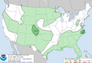
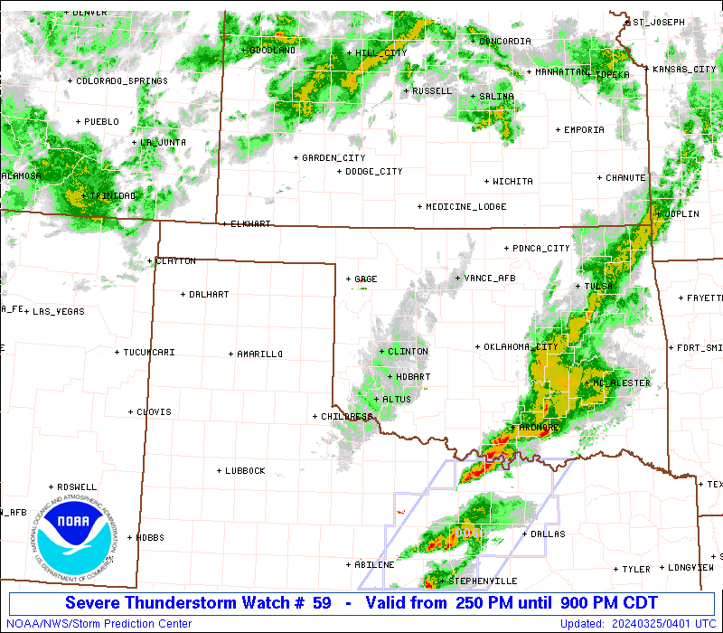
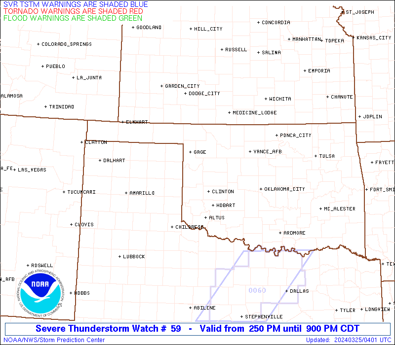
http://www.spc.noaa.gov/products/watch/ww0059.html
| < Previous WW Next WW > |
|
||||||||||||||||||
|
If ,i was chasing today in the south,(in Mississippi)
I would chase in the middle of Brookhaven and McComb 
vendredi 22 mars 2013
River Coombe bursts its banks in Newlyn
https://www.youtube.com/watch?v=01V2sQN_Ro4 Get ready for freezing Friday: Britain braced for weekend of severe
disruption as flooding, heavy snowfall and blizzards wreak havoc
Northern England and Scotland set to be blanketed with snow today
Environment Agency warns of flooding in south-east and south-west
Dozens of schools have been closed across the North and Midlands
The centre of Newlyn in Cornwall is flooded following heavy rain
Emergency services responding to a surge in weather-related call-outs
Amber weather warnings in place across parts of the UK
Australian motorist chased by tornado - 22 March 2013
http://www.youtube.com/watch?v=sUWnm4Dg-TI An Australian driver and passenger survive a close encounter with a
tornado in New South Wales after it came within metres of their vehicle.
The 24-year-old driver, Daniel Clarke, is travelling with his friend
near the town of Mulwala, when the 50-metre tornado appears in a field
next to them. The pair manage to escape the twister amid the flashes of
exploding power lines
Tornado in Bangladesh 22 March 2013
http://www.youtube.com/watch?v=Kqiz92kAHjs Tornado in Bangladesh 22 March 2013.
At least 50 death
At least 50 death
jeudi 21 mars 2013
summer's weather, ,2009 to 2012
http://www.youtube.com/watch?v=gYdnehnN0cs&list=FLRJUX0Pp8e1SXi50nZz4G7A&feature=mh_lolz (Jean Larocque)
European Storm Forecast Experiment
Storm Forecast
Storm Forecast
Valid: Fri 22 Mar 2013 06:00 to Sat 23 Mar 2013 06:00 UTC
Issued: Thu 21 Mar 2013 22:39
Forecaster: TUSCHY
A level 1 was issued for parts of E-C Portugal and W-C Spain mainly for an isolated tornado and large hail event.
Valid: Fri 22 Mar 2013 06:00 to Sat 23 Mar 2013 06:00 UTC
Issued: Thu 21 Mar 2013 22:39
Forecaster: TUSCHY
TWO caravan parks have been razed by a tornado that ripped through Victoria's northeast, injuring 20 people.
http://www.theaustralian.com.au/news/nation/mini-tornadoes-rip-through-victorian-towns/story-e6frg6nf-1226603048502
Witnesses say tornado was like bomb going off
http://au.news.yahoo.com/latest/a/-/latest/16422023/witnesses-say-tornado-was-like-bomb-going-off/
Second video of the storm that hit Mulwala.
http://www.youtube.com/watch?v=deZqTuUuHL0&feature=player_embedded
20 hurt as tornadoes and powerful storms hit Victoria's northeast
http://www.heraldsun.com.au/news/hurt-as-tornado-hits-victorias-northeast/story-e6frf95f-1226602134758
9 DEADS AND 272 INJURIES BY A STORM AND HAIL IN CHINA MARCH 21, 2013
https://www.youtube.com/watch?v=WO49arx9RaM
EXTREME WEATHER: Tornado And Hailstorms Leave 24 Dead In China!
https://www.youtube.com/watch?v=icvMYzE_rdM

http://www.spc.noaa.gov/products/outlook/day1otlk.html
| This is today's forecast for organized severe thunderstorms over the contiguous United States. Please read the description of the risk categories for further information. You may find the latest Day 1 Outlook available as well as all Outlooks issued today online. | Today's Outlook |
|
|
|
| This is tomorrow's forecast for organized severe thunderstorms over the contiguous United States. Please read the description of the risk categories for further information. The latest Day 2 Outlook is available as well as all Outlooks that have been issued today. | Tomorrow's Outlook |
|
|
|
| This is the day after tomorrow's (day 3) forecast for organized severe thunderstorms over the contiguous United States. Please read the description of the risk categories for further information. The latest Day 3 Outlook is available as well as all Outlooks that have been issued today. Note: The 10% and greater probability thunder line is not included on the Day 3 Outlook. | Day 3 Outlook |
|
| |
mercredi 20 mars 2013
Snow, Cold Continue into Spring
http://www.weather.com/news/weather-winter/snow-cold-entering-spring-20130320
European Storm Forecast Experiment
Storm Forecast
Storm Forecast
Valid: Thu 21 Mar 2013 06:00 to Fri 22 Mar 2013 06:00 UTC
Issued: Wed 20 Mar 2013 21:54
Forecaster: GATZEN
A level 1 was issued for northern and eastern Aegean and western Turkey mainly for excessive rain and severe wind gusts.
Valid: Thu 21 Mar 2013 06:00 to Fri 22 Mar 2013 06:00 UTC
Issued: Wed 20 Mar 2013 21:54
Forecaster: GATZEN


European Storm Forecast Experiment
Storm Forecast
Storm Forecast
Valid: Wed 20 Mar 2013 08:00 to Thu 21 Mar 2013 06:00 UTC
Issued: Wed 20 Mar 2013 08:08
Forecaster: PUCIK
A level 1 was issued for Northwestern Algeria and Tunisia mainly for marginally large hail and severe wind gusts.
Valid: Wed 20 Mar 2013 08:00 to Thu 21 Mar 2013 06:00 UTC
Issued: Wed 20 Mar 2013 08:08
Forecaster: PUCIK
mardi 19 mars 2013
BASEBALL SIZE HAIL STORM HIT SOUTH OF E.E.U.U. MARCH 19, 2013
https://www.youtube.com/watch?v=5oWoCG7ABMU
lundi 18 mars 2013
European Storm Forecast Experiment
Storm Forecast
Storm Forecast
Valid: Tue 19 Mar 2013 06:00 to Wed 20 Mar 2013 06:00 UTC
Issued: Tue 19 Mar 2013 00:48
Forecaster: PISTOTNIK
A level 1 was issued for Moldova, Romania, Serbia, coastal Croatia, Bosnia, Montenegro and Albania for severe wind gusts.Valid: Tue 19 Mar 2013 06:00 to Wed 20 Mar 2013 06:00 UTC
Issued: Tue 19 Mar 2013 00:48
Forecaster: PISTOTNIK
A level 1 was issued for parts of France for severe wind gusts and tornadoes.

Tornado Warning
756 PM EDT Mon Mar 18 2013
The National Weather Service in Peachtree City has issued a
* Tornado Warning for...
northern Crisp County in central Georgia
Southern Dooly County in central Georgia
Wilcox County in central Georgia
* until 845 PM EDT
* at 753 PM EDT...National Weather Service Doppler radar indicated a
severe thunderstorm capable of producing a tornado 9 miles west of
Vienna...moving east at 40 mph.
* Other locations in the warning include but are not limited to
Pitts...Pineview...Rochelle and Abbeville.

dimanche 17 mars 2013
http://www.spc.noaa.gov/products/
| This is today's forecast for organized severe thunderstorms over the contiguous United States. Please read the description of the risk categories for further information. You may find the latest Day 1 Outlook available as well as all Outlooks issued today online. | Today's Outlook |
|
|
|
| This is tomorrow's forecast for organized severe thunderstorms over the contiguous United States. Please read the description of the risk categories for further information. The latest Day 2 Outlook is available as well as all Outlooks that have been issued today. | Tomorrow's Outlook |
|
|
European Storm Forecast Experiment
Storm Forecast
Storm Forecast
Valid: Sun 17 Mar 2013 06:00 to Mon 18 Mar 2013 06:00 UTC
Issued: Sun 17 Mar 2013 05:41
Forecaster: VAN DER VELDE
A level 1 was issued for northwestern France mainly for some chance of tornadoes.Valid: Sun 17 Mar 2013 06:00 to Mon 18 Mar 2013 06:00 UTC
Issued: Sun 17 Mar 2013 05:41
Forecaster: VAN DER VELDE
A level 1 was issued for southern Spain and northern Morocco mainly for isolated large hail and severe wind gusts.
Snow in England wow !!!
Snow in England on the 17th of March this is normal. https://www.youtube.com/watch?v=ARmfrUUzyIE
Plainview Haboob & Mudstorm
March 17, 2013 dust storm & mud storm. Wind speed over 40 mph. https://www.youtube.com/watch?v=gJwoewHl9AU
samedi 16 mars 2013
European Storm Forecast Experiment
Storm Forecast
Storm Forecast
Valid: Sat 16 Mar 2013 06:00 to Sun 17 Mar 2013 06:00 UTC
Issued: Fri 15 Mar 2013 21:50
Forecaster: TUSCHY
Valid: Sat 16 Mar 2013 06:00 to Sun 17 Mar 2013 06:00 UTC
Issued: Fri 15 Mar 2013 21:50
Forecaster: TUSCHY
A level 1 was issued for SW UK mainly for an isolated large hail and tornado risk.
Snowstorm in Minsk - Снежная буря в Минске. 15 March 2013.
https://www.youtube.com/watch?v=_jmV2aVYAcw
Завея ў Менску (Беларусь) / Snowstorm in Minsk (Belarus)
https://www.youtube.com/watch?v=yqzRxUDGklM
vendredi 15 mars 2013
http://www.spc.noaa.gov/products/
| Convective Outlooks | |
|---|---|
| This is today's convective outlook valid from 1Z to 12Z for organized severe thunderstorms over the contiguous United States. Please read the description of the risk categories for further information. You may find the Day 1 Outlook available as well as all Outlooks issued today online. | Day 1 Outlook Valid till 12Z |
| |
| This is today's forecast for organized severe thunderstorms over the contiguous United States. Please read the description of the risk categories for further information. You may find the latest Day 1 Outlook available as well as all Outlooks issued today online. | Today's Outlook |
| |
| This is tomorrow's forecast for organized severe thunderstorms over the contiguous United States. Please read the description of the risk categories for further information. The latest Day 2 Outlookis available as well as all Outlooks that have been issued today. | Tomorrow's Outlook |
| |
| This is the day after tomorrow's (day 3) forecast for organized severe thunderstorms over the contiguous United States. Please read the description of the risk categories for further information. The latest Day 3 Outlook is available as well as all Outlooks that have been issued today. Note: The 10% and greater probability thunder line is not included on the Day 3 Outlook. | Day 3 Outlook |
| |
| This is the day 4-8 forecast for organized severe thunderstorms over the contiguous United States. The latest Day 4-8 Outlook is available as well as all Outlooks that have been issued today.Note: A severe weather area depicted in the Day 4-8 period indicates a 30% or higher probability for severe thunderstorms (e.g. a 30% chance that a severe thunderstorm will occur within 25 miles of any point). | Day 4-8 Outlook |
| |
jeudi 14 mars 2013
European Storm Forecast Experiment
Storm Forecast
Storm Forecast
Valid: Fri 15 Mar 2013 06:00 to Sat 16 Mar 2013 06:00 UTC
Issued: Thu 14 Mar 2013 17:54
Forecaster: TUSCHY
Valid: Fri 15 Mar 2013 06:00 to Sat 16 Mar 2013 06:00 UTC
Issued: Thu 14 Mar 2013 17:54
Forecaster: TUSCHY
A level 1 was issued for parts of the Aegean Sea and W-Turkey mainly for a few waterspout events (an isolated strong event possible) and isolated large hail.
A level 1 was issued for NE Romania, parts of Moldova and parts of the Ukraine mainly for an isolated tornado event and gusty winds.
A level 1 was issued for NE Romania, parts of Moldova and parts of the Ukraine mainly for an isolated tornado event and gusty winds.
mercredi 13 mars 2013
INACREDITÁVEL! Atingido por um raio! UNBELIEVABLE! Struck by a lightnin
https://www.youtube.com/watch?v=suqJSfg_beA
European Storm Forecast Experiment
Storm Forecast
Storm Forecast
Valid: Thu 14 Mar 2013 06:00 to Thu 14 Mar 2013 06:00 UTC
Issued: Wed 13 Mar 2013 22:33
Forecaster: GATZEN
Valid: Thu 14 Mar 2013 06:00 to Thu 14 Mar 2013 06:00 UTC
Issued: Wed 13 Mar 2013 22:33
Forecaster: GATZEN
A level 1 was issued for the southern Adriatic mainly for excessive precipitation.
A level 1 was issued for the southern Balkans, eastern Bulgaria and Romania mainly for large hail, tornadoes, and severe wind gusts.
A level 1 was issued for the southern Balkans, eastern Bulgaria and Romania mainly for large hail, tornadoes, and severe wind gusts.
Thunderstorms near Karlovac, Županje and Zagreb, leeches near Split (PHOTO)
Deep and spacious Mediterranean cyclones Hope stood in the middle of Wednesday its center over the western Mediterranean and Genovsksom bay, but will in the coming nights rapidly across Liguria Sea and central Italy, moved into the Adriatic Sea where it will be further deepened, and then enter through Dalmatia over BH, and continue their "land" the way to Ukraine.
http://www.crometeo.hr/nevrijeme-kod-karlovca-zupanje-i-zagreba-pijavica-kod-splita-foto/
Leech of Kastela Bay. Photo: Peter Sisko

European Storm Forecast Experiment
Storm Forecast
Storm Forecast
Valid: Wed 13 Mar 2013 06:00 to Thu 14 Mar 2013 06:00 UTC
Issued: Wed 13 Mar 2013 03:17
Forecaster: TUSCHY
Valid: Wed 13 Mar 2013 06:00 to Thu 14 Mar 2013 06:00 UTC
Issued: Wed 13 Mar 2013 03:17
Forecaster: TUSCHY
A level 1 was issued for parts of N-Italy mainly for locally heavy rainfall amounts and an isolated tornado risk.
A level 1 was issued for Montenegro and parts of NW-Albania mainly for excessive rainfall amounts.
A level 1 was issued for Montenegro and parts of NW-Albania mainly for excessive rainfall amounts.
mardi 12 mars 2013
Tempête de Neige à Lille (59) France | Blizzard | Mardi 12 Mars 2013 | HD
https://www.youtube.com/watch?v=PYFbCPYXkCI
Tempête de neige incroyable et historique du 12 mars 2013
https://www.youtube.com/watch?v=WHt8Npj0WHw
Crazy Hail Storm And Dude Tries To Protect His Car With His Own Hands.
https://www.youtube.com/watch?v=ToQ4Tzq97Pw Hey! man what...the...
http://www.crometeo.hr/niz-pijavica-u-dalmaciji-nevrijeme-u-slavoniji-foto/

A series of leeches in Dalmatia, a storm in (PHOTO)
lundi 11 mars 2013
Orage du 10 mars 2013 - Foudre éclair - Lightning strike ! [HD]
https://www.youtube.com/watch?v=BlPbxHXlUso
European Storm Forecast Experiment
Storm Forecast
Storm Forecast
Valid: Tue 12 Mar 2013 06:00 to Wed 13 Mar 2013 06:00 UTC
Issued: Mon 11 Mar 2013 19:25
Forecaster: PISTOTNIK
Valid: Tue 12 Mar 2013 06:00 to Wed 13 Mar 2013 06:00 UTC
Issued: Mon 11 Mar 2013 19:25
Forecaster: PISTOTNIK
A level 1 was issued for parts of Turkey mainly for severe wind gusts and large hail, and to a lesser degree for excessive precipitation and tornadoes.
A level 1 was issued for parts of Southern Italy mainly for excessive precipitation.
A level 1 was issued for parts of Southern Portugal and Southern Spain for severe wind gusts.
A level 1 was issued for parts of Southern Italy mainly for excessive precipitation.
A level 1 was issued for parts of Southern Portugal and Southern Spain for severe wind gusts.