| Convective Outlooks | |
|---|---|
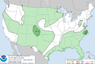
| This is today's convective outlook valid from 1Z to 12Z for organized severe thunderstorms over the contiguous United States. Please read the description of the risk categories for further information. You may find the Day 1 Outlook available as well as all Outlooks issued today online. | Day 1 Outlook Valid till 12Z |
|
|
| This is today's forecast for organized severe thunderstorms over the contiguous United States. Please read the description of the risk categories for further information. You may find the latest Day 1 Outlook available as well as all Outlooks issued today online. | Today's Outlook |

|
|
| This is tomorrow's forecast for organized severe thunderstorms over the contiguous United States. Please read the description of the risk categories for further information. The latest Day 2 Outlook is available as well as all Outlooks that have been issued today. | Tomorrow's Outlook |

|
|
| This is the day after tomorrow's (day 3) forecast for organized severe thunderstorms over the contiguous United States. Please read the description of the risk categories for further information. The latest Day 3 Outlook is available as well as all Outlooks that have been issued today. Note: The 10% and greater probability thunder line is not included on the Day 3 Outlook. | Day 3 Outlook |

|
|
| This is the day 4-8 forecast for organized severe thunderstorms over the contiguous United States. The latest Day 4-8 Outlook is available as well as all Outlooks that have been issued today. Note: A severe weather area depicted in the Day 4-8 period indicates a 30% or higher probability for severe thunderstorms (e.g. a 30% chance that a severe thunderstorm will occur within 25 miles of any point). | Day 4-8 Outlook |

| |
jeudi 28 mars 2013
Inscription à :
Publier les commentaires (Atom)
Aucun commentaire:
Enregistrer un commentaire