mardi 31 mars 2015
http://www.spc.noaa.gov/products/watch/
| Current Convective Watches (View What is a Watch? clip) Updated: Wed Apr 1 02:10:07 UTC 2015   |


European Storm Forecast Experiment
Storm Forecast
Storm Forecast
Valid: Wed 01 Apr 2015 06:00 to Thu 02 Apr 2015 06:00 UTC
Issued: Wed 01 Apr 2015 01:42
Forecaster: PUCIK
Valid: Wed 01 Apr 2015 06:00 to Thu 02 Apr 2015 06:00 UTC
Issued: Wed 01 Apr 2015 01:42
Forecaster: PUCIK
A level 1 was issued for parts of BENELUX, Germany, Austria, W Poland, Czech Republic, W Slovakia, Hungary and W Romania mainly for severe wind gusts and to the lesser degree for tornadoes.
A level 1 was issued for Ukraine to E Belarus mainly for severe wind gusts and to the lesser degree for tornadoes.
SYNOPSIS
An outbreak of arctic maritime airmass is ongoing over much of western and central Europe in the wake of the large trough. Prevailing northwesterly flow will overspread a belt from the Atlantic towards northern Balkans. In this belt, unstable conditions will prevail with scattered to widespread low topped showers and thunderstorms. Also thanks to the strong pressure gradient between a high centered over the Atlantic and a low centered over the Baltic states, strong background flow with widespread gusts over 20 m/s and isolated gusts over 25 m/s is forecast.
| This is tomorrow's forecast for organized severe thunderstorms over the contiguous United States. Please read the description of Convective Outlooks for further information. The latest Day 2 Outlook is available as well as all Convective Outlooks that have been issued today. | Tomorrow's Outlook |
 | |
| This is the day after tomorrow's (day 3) forecast for organized severe thunderstorms over the contiguous United States. Please read the description of Convective Outlooks for further information. The latest Day 3 Outlook is available as well as all Convective Outlooks that have been issued today. | Day 3 Outlook |
 |
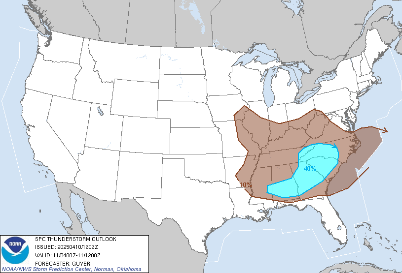
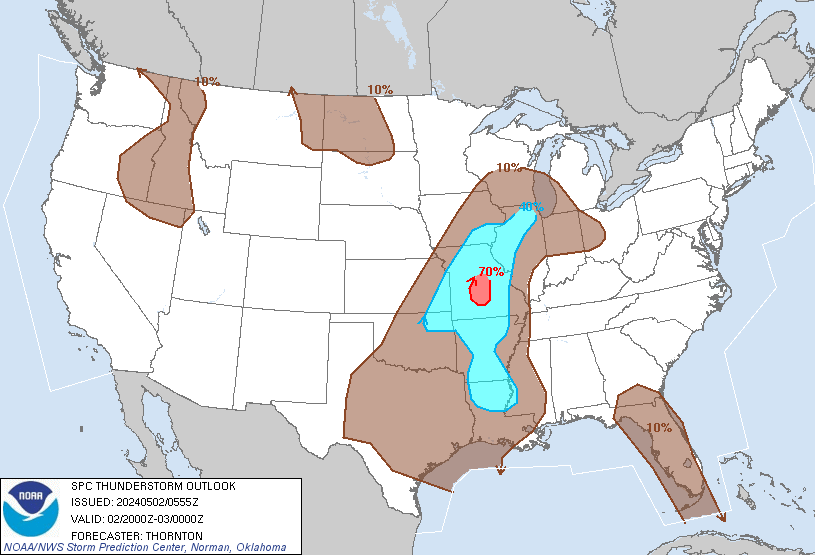
Mar 31, 2015 0600 UTC Day 1 Convective Outlook
 DAY 1 CONVECTIVE OUTLOOK
 NWS STORM PREDICTION CENTER NORMAN OK 1252 AM CDT TUE MAR 31 2015 VALID 311200Z - 011200Z ...THERE IS A SLGT RISK OF SVR TSTMS FOR SWRN OK AND WRN N-CNTRL TX... ...THERE IS A MRGL RISK OF SVR TSTMS SURROUNDING THE SLIGHT RISK FROM W TX THROUGH AR TO SRN GA/NRN FL... ...SUMMARY... ISOLATED SEVERE THUNDERSTORMS ARE EXPECTED TO DEVELOP ACROSS SOUTHWESTERN OKLAHOMA AND WESTERN NORTH-CENTRAL TEXAS. SCATTERED STORMS...A FEW STRONG...ARE EXPECTED FROM ARKANSAS INTO SOUTHERN GEORGIA AND NORTHERN FLORIDA. ...SYNOPSIS... AN AMPLIFIED UPPER-AIR PATTERN WILL FEATURE PROGRESSIVE MID-LEVEL TROUGHS MOVING ACROSS THE PACIFIC NW/NRN ROCKIES AND THE GREAT LAKES INTO THE MID-ATLANTIC STATES. A LOWER-LATITUDE TROUGH AND ASSOCIATED MID-LEVEL LOW OVER NRN MEXICO WILL TRANSLATE EWD AND PRIMARILY INFLUENCE THE TX-MEXICO BORDER REGION TO THE S OF A RIDGE LOCATED OVER THE NRN PLAINS. IN THE LOW LEVELS...A SURFACE LOW WILL FORM E OF THE CANADIAN ROCKIES WITH AN ASSOCIATED TROUGH IN LEE OF THE ROCKIES. A SECONDARY AREA OF LOW PRESSURE WILL DEVELOP DURING THE DAY OVER NWRN TX WITH AN ATTENDANT DRYLINE.

European Storm Forecast Experiment
Storm Forecast
Storm Forecast
Valid: Tue 31 Mar 2015 06:00 to Wed 01 Apr 2015 06:00 UTC
Issued: Mon 30 Mar 2015 16:19
Forecaster: TUSCHY
Valid: Tue 31 Mar 2015 06:00 to Wed 01 Apr 2015 06:00 UTC
Issued: Mon 30 Mar 2015 16:19
Forecaster: TUSCHY
A level 1 was issued for many parts of NW/CNTRL Europe mainly for severe/damaging wind gusts and an isolated tornado threat.
SYNOPSIS
Diversified/progressive weather pattern continues over many European regions with one trough exiting towards E-Europe while another system will be close on it's heels. Latest model guidance places this new feature over the northern North Sea around 06 Z and crossing the Baltic Sea during the overnight hours.
This deep vortex is more or less vertically stacked and hence won't move that fast to the east. Latest analysis would favor a so called flat trough cyclogenesis in a diffluent flow regime. The low/mid-tropospheric vortex remains rather stable regarding intensity fluctuations despite being placed in the left exit of a 80 m/s polar jet streak. In fact, strongest upper divergence becomes displaced to the east betimes. Still, ongoing moderate pressure fall occurs with aforementioned dynamics and as the Azores high moves east with slight intensification expected (1035 hPa plus), intense pressure gardient will be in place over a rather broad region.
In addition, this vortex comprised a plume of modified subtropical air over the E-Atlantic, which becomes advected towards its center and betimes also wraps around the core of the strong/deep vortex. Latest phase diagrams reflect that scenario with a well structured and rather deep shallow warm-core structure. This will bring the focus for intense gradient flow to the SW-part of its center.
A highly meridional trough over E/SE Europe shifts east as deep WAA of the N-European low spreads east. Rising mid-level heights ensure stable conditions for SW Europe.
mercredi 25 mars 2015


Mar 25, 2015 0600 UTC Day 1 Convective Outlook


DAY 1 CONVECTIVE OUTLOOK
   NWS STORM PREDICTION CENTER NORMAN OK
   1244 AM CDT WED MAR 25 2015

   VALID 251200Z - 261200Z

   ...THERE IS AN ENH RISK OF SVR TSTMS LATE THIS AFTERNOON AND EVENING
   ACROSS PARTS OF NORTH CENTRAL AND NORTHEAST OKLAHOMA...ADJACENT
   SOUTHEAST KANSAS...SOUTHWEST MISSOURI AND NORTHWEST ARKANSAS...

   ...THERE IS A SLGT RISK OF SVR TSTMS SURROUNDING THE ENH
   RISK...ACROSS PARTS OF THE SOUTH CENTRAL PLAINS INTO THE OZARK
   PLATEAU...

   ...THERE IS A MRGL RISK OF SVR TSTMS ACROSS SURROUNDING AREAS OF THE
   CENTRAL AND SOUTHERN PLAINS EAST NORTHEASTWARD INTO PARTS OF THE
   LOWER OHIO VALLEY...

   ...SUMMARY...
   SEVERE THUNDERSTORMS...MAINLY CAPABLE OF PRODUCING LARGE HAIL AND
   LOCALLY DAMAGING WIND GUSTS...ARE EXPECTED ACROSS PARTS OF THE SOUTH
   CENTRAL PLAINS INTO THE OZARK PLATEAU LATE THIS AFTERNOON AND
   EVENING.

   ...SYNOPSIS...
   SIGNIFICANT AMPLIFICATION IS ONGOING WITHIN A BRANCH OF MID-LATITUDE
   WESTERLIES ACROSS THE EASTERN PACIFIC INTO WESTERN NORTH AMERICA.
   AS LARGE-SCALE MID/UPPER RIDGING CONTINUES TO BUILD NEAR THE PACIFIC
   COAST DURING THIS PERIOD...MODELS INDICATE THAT LARGE-SCALE
   TROUGHING WILL BEGIN TO EVOLVE DOWNSTREAM...EAST OF THE
   ROCKIES...THROUGH THE VICINITY OF THE APPALACHIANS.

   WITHIN THIS LATTER REGIME...ONE NOTABLE SHORT WAVE IMPULSE IS
   FORECAST TO PIVOT RAPIDLY NORTHEASTWARD...FROM THE OHIO VALLEY
   THROUGH THE ST. LAWRENCE VALLEY BY LATE TONIGHT.  AN ASSOCIATED
   SURFACE LOW MAY CONSOLIDATE WITH ANOTHER LOW OVER THE GREAT LAKES
   REGION...BEFORE CONTINUING INTO QUEBEC LATE IN THE PERIOD...WITH A
   TRAILING COLD FRONT ADVANCING SOUTHEASTWARD ACROSS THE CENTRAL
   UNITED STATES.

   INITIALLY STALLED OVER PARTS OF THE LOWER OHIO VALLEY/OZARK PLATEAU
   AND CENTRAL PLAINS...MODELS SUGGEST THAT THE SOUTHWESTERN FLANK OF
   THIS FRONT WILL BEGIN A MORE RAPID SOUTHWARD SURGE...IN RESPONSE TO
   ANOTHER SIGNIFICANT SHORT WAVE IMPULSE DIGGING SOUTHEAST OF THE
   CENTRAL ROCKIES THROUGH MUCH OF THE SOUTH CENTRAL PLAINS BY 12Z
   THURSDAY.  THIS MAY BE ACCOMPANIED BY WIDESPREAD CONVECTIVE
   DEVELOPMENT...AND THE RISK FOR SEVERE STORMS.

   ...SOUTH CENTRAL PLAINS/OZARK PLATEAU INTO LOWER OHIO VALLEY...
   SOME BOUNDARY LAYER MOISTENING CONTINUES ALONG AND SOUTH OF THE
   FRONT...BUT A SUBSTANTIVE RETURN FLOW OF MOISTURE OFF THE GULF OF
   MEXICO STILL APPEARS UNLIKELY DURING THIS PERIOD.  MODEL SURFACE DEW
   POINT FORECASTS FOR THIS AFTERNOON MAY STILL BE AT LEAST A BIT TOO
   HIGH.  HOWEVER...NORTHEASTWARD ADVECTION OF WARM ELEVATED MIXED
   LAYER AIR IS EXPECTED TO AGAIN CONTRIBUTE TO VERY STEEP MID-LEVEL
   LAPSE RATES BY THIS AFTERNOON.  THIS PROBABLY WILL SUPPORT SIZABLE
   CAPE /PERHAPS AT OR ABOVE 2000 J PER KG/ WITHIN AT LEAST A NARROW
   CORRIDOR ALONG THE FRONTAL ZONE.  IN THE PRESENCE OF STRONG SHEAR
   BENEATH 40-50 KT WESTERLY 500 MB FLOW...CONDITIONS SHOULD BECOME
   CONDUCIVE TO THE DEVELOPMENT OF SEVERE STORMS FOR AT LEAST A PERIOD
   LATE THIS AFTERNOON INTO EARLY EVENING.

   MODELS SUGGEST THAT FORCING FOR ASCENT ASSOCIATED WITH LOW-LEVEL
   WARM ADVECTION MAY SUPPORT A RAPID INCREASE IN SEVERE STORM
   DEVELOPMENT BY 20-22Z NEAR THE CENTRAL AND EASTERN KANSAS/OKLAHOMA
   BORDER AREA.  THIS MAY INITIALLY INCLUDE DISCRETE STORMS...BEFORE
   GROWING UPSCALE...WHICH SHOULD TEND TO TRACK EASTWARD ALONG THE
   FRONT INTO THE OZARK PLATEAU.  ADDITIONAL SEVERE STORMS MAY FORM
   SHORTLY THEREAFTER ACROSS PARTS OF WEST CENTRAL OKLAHOMA.  IT
   APPEARS THAT THIS LATTER ACTIVITY WILL OCCUR JUST AHEAD OF THE
   SOUTHWARD SURGING COLD FRONT...AND STRONGER STORMS PROBABLY WILL BE
   CAPABLE OF PRODUCING LARGE HAIL AND LOCALLY STRONG WIND GUSTS.

   AS LARGE-SCALE FORCING SUPPORTS INCREASINGLY WIDESPREAD THUNDERSTORM
   ACTIVITY THROUGH MUCH OF THE INSTABILITY AXIS...WHILE THE SURFACE
   COLD FRONT BEGINS TO SURGE SOUTHWARD AND TENDS TO UNDERCUT
   CONVECTION...IT REMAINS UNCLEAR AT THE PRESENT TIME HOW LONG THE
   SEVERE WEATHER POTENTIAL WILL CONTINUE INTO THE EVENING HOURS.
mardi 24 mars 2015
Tomorrow's Outlook

DAY 2 CONVECTIVE OUTLOOK
   NWS STORM PREDICTION CENTER NORMAN OK
   1140 PM CDT MON MAR 23 2015

   VALID 251200Z - 261200Z

   ...THERE IS AN ENH RISK OF SVR TSTMS ACROSS THE MAIN BODY OF OK INTO
   NWRN TX...

   ...THERE IS A SLGT RISK OF SVR TSTMS FROM NW TX TO SRN IL...

   ...THERE IS A MRGL RISK OF SVR TSTMS FROM SWRN TX TO NRN KY...

   ...SUMMARY...
   SEVERE THUNDERSTORMS ARE EXPECTED TO DEVELOP ALONG A COLD FRONT
   STRETCHING FROM PORTIONS OF THE MID MISSISSIPPI VALLEY...SOUTHWEST
   INTO THE SOUTHERN PLAINS OF OKLAHOMA AND TEXAS WEDNESDAY
   AFTERNOON/EVENING.  LARGE HAIL AND DAMAGING WINDS ARE THE PRIMARY
   THREATS CONTINUING INTO THE OVERNIGHT HOURS.

Mar 24, 2015 0600 UTC Day 1 Convective Outlook


DAY 1 CONVECTIVE OUTLOOK
   NWS STORM PREDICTION CENTER NORMAN OK
   1206 AM CDT TUE MAR 24 2015

   VALID 241200Z - 251200Z

   ...THERE IS A SLGT RISK OF SVR TSTMS TODAY ACROSS PARTS OF
   NORTHEASTERN OKLAHOMA...NORTHWESTERN ARKANSAS...AND SOUTHWESTERN
   THROUGH CENTRAL MISSOURI...

   ...THERE IS A MRGL RISK OF SVR TSTMS ACROSS SURROUNDING AREAS OF THE
   EAST CENTRAL PLAINS...OZARK PLATEAU AND MIDDLE MISSISSIPPI VALLEY...

   ...SUMMARY...
   SCATTERED STRONG TO SEVERE STORMS ARE POSSIBLE TODAY ACROSS PARTS OF
   THE EAST CENTRAL PLAINS...OZARK PLATEAU AND MIDDLE MISSISSIPPI
   VALLEY.

   ...SYNOPSIS...
   AMPLIFICATION OF THE MID-LATITUDE WESTERLIES NOW APPEARS UNDERWAY
   ACROSS THE CENTRAL AND EASTERN PACIFIC.  SUBSTANTIAL FURTHER
   AMPLIFICATION APPEARS LIKELY TODAY THROUGH TONIGHT...WITH UPPER
   RIDGING BUILDING ALONG AND JUST WEST OF THE PACIFIC COAST...IN
   ADVANCE OF A DEEPENING UPPER TROUGH.  DOWNSTREAM...UPPER TROUGHING
   MAY BEGIN TO DIG ACROSS THE GREAT BASIN AND FOUR CORNERS
   REGION...BUT FLOW EAST OF THE ROCKIES IS EXPECTED TO REMAIN MORE OR
   LESS ZONAL THROUGH THIS PERIOD.


vendredi 20 mars 2015
European Storm Forecast Experiment
Storm Forecast
Storm Forecast
Valid: Fri 20 Mar 2015 06:00 to Sat 21 Mar 2015 06:00 UTC
Issued: Thu 19 Mar 2015 23:17
Forecaster: TUSCHY
Valid: Fri 20 Mar 2015 06:00 to Sat 21 Mar 2015 06:00 UTC
Issued: Thu 19 Mar 2015 23:17
Forecaster: TUSCHY
A level 1 was issued for S/E Spain mainly for excessive rain, large hail and an isolated tornado event.
SYNOPSIS
Looking at the 500 hPa loop makes one dizzy as various upper lows affect many parts of Europe. A vertically stacked vortex over the Iberian Peninsula drifts a bit to the east with no major fluctuations in strength. A smaller upper cold-core low over W-France gets caught by the Spanish vortex and continues to move to the SW over the Bay of Biscay, over extreme NW Spain and thereafter towards the open Atlantic. Regarding the mid-levels, a cold-core low over SE Europe features the coldest air with 500 hPa readings around -35 °C. It shifts a bit to the SE towards Turkey with rather cold air filtering in from the NW.
Very cold air invades NE Europe with enhanced convection over offshore areas due to the augmented heat flux. No DMC activity occurs during the forecast.
mercredi 18 mars 2015
mardi 17 mars 2015
lundi 16 mars 2015
European Storm Forecast Experiment
Storm Forecast
Storm Forecast
Valid: Mon 16 Mar 2015 06:00 to Tue 17 Mar 2015 06:00 UTC
Issued: Mon 16 Mar 2015 04:18
Forecaster: VAN DER VELDE
Valid: Mon 16 Mar 2015 06:00 to Tue 17 Mar 2015 06:00 UTC
Issued: Mon 16 Mar 2015 04:18
Forecaster: VAN DER VELDE
A level 1 was issued for Sardinia and Sicily mainly for chances of isolated large hail, tornadoes and excessive convective precipitation.
SYNOPSIS / DISCUSSION
An upper trough is located over western Europe, with relatively shallow storms with isolated thunder in th slightly unstable cold airmass over France and the western Mediterranean. The weak surface low shifts from northeastern Spain to Corsica/Sardinia with a plume of warm unstable air advecting from Tunesia and the Thyrrenian Sea northwestward into an occlusion over the northern Mediterranean basin. MUCAPE of 100-400 J/kg is concentrated mainly along a cold front between Tunesia and Sardinia. Low level convergence is focused into a line which should trigger storms which move only slowly (<5 m/s) while moisture transport is lifted over the east coast of Sardinia. It combines with moderate vertical wind shear (15 m/s and 150-250 m²/s² 0-3 km SREH). Some supercells may form in such environment, whose main threat is large hail and local excessive precipitation. The low levels are very humid and have 0-1 km shear around 10 m/s, which enhance precipitation and tornado chances.
A new low will arrive to Portugal early Tuesday. Its cold front is backed by a healthy PV lobe which may trigger a linear convective system, but CAPE is rather low and barely reaches the coast before 06Z.
dimanche 15 mars 2015
Putty Hailstorm 12th March 2015,,,,,,,,, By jimmydeguara .Check out is great youtube channel at www.youtube.com/user/jimmydeguara
Giant hailstones and dangerous lightning Putty. Several supercells exploded during the early evening and hit the Blue Mountains and Wollemi National

Atlantic blizzard: find out what you need to know to prepare for the East Coast storm,,,,,,,,,,,,LIVE on the Weather Network
http://www.theweathernetwork.com/news/articles/winter-weather-set-to-return-to-the-east-coast/47074/
Atlantic blizzard: find out what you need to know to prepare for the East Coast storm,,,,,,,,,,,,,,,,,,,,,,,,,,,http://www.theweathernetwork.com/news/articles/winter-weather-set-to-return-to-the-east-coast/47074/

Closings & Cancellations
- Nova Scotia: Halifax and Cape Breton overnight street parking ban enforced 1 a.m - 6 a.m., Sunday, March 15. Cape Breton has also banned street parking until two hours after the snow stops.
- The Moose Run road race has been postponed until a later date.
- New Brunswick: The Moncton campus of the Université de Moncton is closed and any activities scheduled for Sunday have been cancelled.
- Mass services at St Francis of Assisi Parish, St James Lakewood, Saint John Baptist and St Clement, and many others are cancelled for Sunday.
- Prince Edward Island: The provincial hockey championship are cancelled on Sunday. Services in many churches in the provinces were also not expected to occur.
For Newfoundland, the storm won't find its way into the province until late Sunday and into Monday.

http://www.theweathernetwork.com/news/articles/winter-weather-set-to-return-to-the-east-coast/47074/


Inscription à :
Articles (Atom)