mardi 30 avril 2013
UP-CLOSE tornado video from Deep South, Texas yesterday! April 29, 2013
http://www.youtube.com/watch?v=-lYM81LDuRM
lundi 29 avril 2013
MINI TORNADO (DUST DEVIL) LIFTS WHOLE WAREHOUSE OFF GROUND IN CHINA
https://www.youtube.com/watch?v=HHFysNY3jBI
dimanche 28 avril 2013
Tornado Warning
2013-04-28 17:36:00 EDT until
2013-04-28 18:15:00 EDT
536 PM EDT sun Apr 28 2013
2013-04-28 18:15:00 EDT
The National Weather Service in Columbia has issued a
* Tornado Warning for...
northwestern McDuffie County in east central Georgia
Southern Lincoln County in east central Georgia
* until 615 PM EDT
* at 533 PM EDT...National Weather Service Doppler radar indicated
a severe thunderstorm capable of producing a tornado. The storm will
move into northern McDuffie County shortly.
* The tornado will otherwise remain over mainly rural areas of the
indicated counties.

Tornado Warning
441 PM EDT sun Apr 28 2013
The National Weather Service in Peachtree City has issued a
* Tornado Warning for...
east central Greene County in east central Georgia
northern Taliaferro County in east central Georgia
Wilkes County in east central Georgia
* until 530 PM EDT
* at 436 PM EDT...National Weather Service Doppler radar indicated a
severe thunderstorm capable of producing a tornado 17 miles
southwest of Washington...moving northeast at 30 mph.
* Other locations in the warning include but are not limited to
Tignall.
Storm capable of producing a tornado
Tornado Vortex Signature (CAE_T9)
| ID: | T9 |
| Location: | Greene |
| Max: | 60 dBZ |
| Top: | 31,000 ft. |
| VIL: | 53 kg/m² |
| Chance of Severe Hail: | 80% |
| Chance of Hail: | 100% |
| Max Hail Size: | 1.25 in. |
| Speed: | 19 knots |
| Direction (from): | WSW (249) |
TwisterChasers "We Take You Up Close and Personal to The Wildest Weather on EART
https://www.youtube.com/watch?v=ABKY8MqNGvo
April 27, 2013 East Arkansas Severe Storm near Holly Grove, AR
https://www.youtube.com/watch?v=wDOhl-Aat6M
samedi 27 avril 2013
Mesoscale Discussion 565
| < Previous MD | |

|
|
MESOSCALE DISCUSSION 0565 NWS STORM PREDICTION CENTER NORMAN OK 0454 PM CDT SAT APR 27 2013 AREAS AFFECTED...NERN MS...NRN AL...FAR NWRN GA CONCERNING...SEVERE POTENTIAL...WATCH POSSIBLE VALID 272154Z - 272300Z PROBABILITY OF WATCH ISSUANCE...60 PERCENT | |

SEL1
URGENT - IMMEDIATE BROADCAST REQUESTED
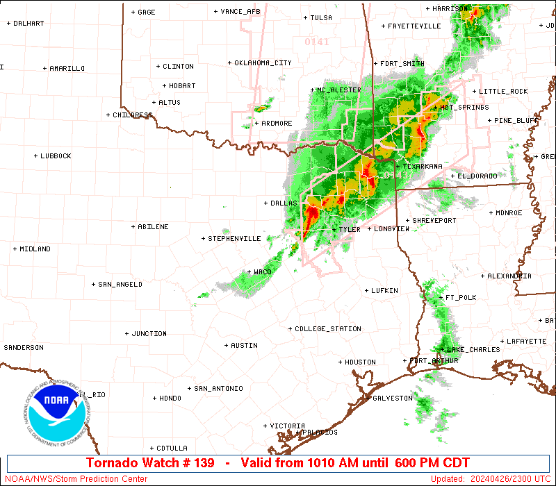
TORNADO WATCH NUMBER 141
NWS STORM PREDICTION CENTER NORMAN OK
350 PM CDT SAT APR 27 2013
THE NWS STORM PREDICTION CENTER HAS ISSUED A
* TORNADO WATCH FOR PORTIONS OF
EAST CENTRAL ARKANSAS
NORTHERN MISSISSIPPI
SOUTHWEST TENNESSEE
* EFFECTIVE THIS SATURDAY AFTERNOON AND EVENING FROM 350 PM UNTIL
1100 PM CDT.


vendredi 26 avril 2013
mardi 23 avril 2013
TwisterChasers Intercept Hail filled Storms on the OK/KS border April 22, 2013
https://www.youtube.com/watch?v=AUa7Hk8fBlg
4/22/2013 Severe Evening Supercell from Kingfisher to OKC
https://www.youtube.com/watch?v=y7Hr-Pdi-n4
4/22/2013 Twin Cities Area of Minnesota Winter Storm B Roll Footage
https://www.youtube.com/watch?v=CLM9WJhjOws
lundi 22 avril 2013
Convective Outlooks
| This is today's convective outlook valid from 1Z to 12Z for organized severe thunderstorms over the contiguous United States. Please read the description of the risk categories for further information. You may find the Day 1 Outlook available as well as all Outlooks issued today online. | Day 1 Outlook Valid till 12Z |
|
|
| This is today's forecast for organized severe thunderstorms over the contiguous United States. Please read the description of the risk categories for further information. You may find the latest Day 1 Outlook available as well as all Outlooks issued today online. | Today's Outlook |

|
|
| This is tomorrow's forecast for organized severe thunderstorms over the contiguous United States. Please read the description of the risk categories for further information. The latest Day 2 Outlook is available as well as all Outlooks that have been issued today. | Tomorrow's Outlook |

|
|
| This is the day after tomorrow's (day 3) forecast for organized severe thunderstorms over the contiguous United States. Please read the description of the risk categories for further information. The latest Day 3 Outlook is available as well as all Outlooks that have been issued today. Note: The 10% and greater probability thunder line is not included on the Day 3 Outlook. | Day 3 Outlook |

|
dimanche 21 avril 2013
BREAKING NEWS China EARTHQUAKE- Dozens KILLED 100's INJURED in SICHUAN -
https://www.youtube.com/watch?v=w7obUaCumZ0
CENAS INCRÍVEIS TERREMOTO NA CHINA 20/04/2013 6.6 MAGNITUDE ! HD720P
https://www.youtube.com/watch?v=dbPX12_Strg
European Storm Forecast Experiment
Storm Forecast
Storm Forecast
Valid: Sun 21 Apr 2013 06:00 to Mon 22 Apr 2013 06:00 UTC
Issued: Sun 21 Apr 2013 00:21
Forecaster: VAN DER VELDE
A level 1 was issued for Italy and western Balkan mainly for isolated large hail.
Valid: Sun 21 Apr 2013 06:00 to Mon 22 Apr 2013 06:00 UTC
Issued: Sun 21 Apr 2013 00:21
Forecaster: VAN DER VELDE
vendredi 19 avril 2013

jeudi 18 avril 2013
mercredi 17 avril 2013
Overlay WATCH LIVE: Tornado Hunt Autoplay On Off The Tornado Hunt team is on the chase in the Midwest. Watch th
http://www.weather.com/tv/tvshows/live-stream
mardi 16 avril 2013
NWS Wichita, KS http://www.crh.noaa.gov/wxstory.php?site=ict

Strong
to severe thunderstorms are expected on Wednesday across south central
and southeast Kansas. The greatest risk for severe weather is expected
to occur along a surface front which will creep into southeast Kansas.
Damaging winds, large hail and even a tornado will be possible along
this boundary across southeast Kansas during the late afternoon and
early evening.
NWS Springfield, MO http://www.crh.noaa.gov/wxstory.php?site=sgf

An
unsettled weather pattern will continue across the region late
Wednesday into Thursday. A strengthening cold front will begin to move
east toward the Ozarks. An area of strong to severe thunderstorms is
expected to develop along and ahead of this front, and will push into
the region late Wednesday into the early morning hours on Thursday. The
chance for strong storms, along with the potential for heavy rainfall,
will continue through much of the day on Thursday.


lundi 15 avril 2013
Convective Outlooks
| This is today's forecast for organized severe thunderstorms over the contiguous United States. Please read the description of the risk categories for further information. You may find the latest Day 1 Outlook available as well as all Outlooks issued today online. | Today's Outlook |
|
|
|
| This is tomorrow's forecast for organized severe thunderstorms over the contiguous United States. Please read the description of the risk categories for further information. The latest Day 2 Outlook is available as well as all Outlooks that have been issued today. | Tomorrow's Outlook |
|
|
|
| This is the day after tomorrow's (day 3) forecast for organized severe thunderstorms over the contiguous United States. Please read the description of the risk categories for further information. The latest Day 3 Outlook is available as well as all Outlooks that have been issued today. Note: The 10% and greater probability thunder line is not included on the Day 3 Outlook. | Day 3 Outlook |
|
|
|
| This is the day 4-8 forecast for organized severe thunderstorms over the contiguous United States. The latest Day 4-8 Outlook is available as well as all Outlooks that have been issued today. Note: A severe weather area depicted in the Day 4-8 period indicates a 30% or higher probability for severe thunderstorms (e.g. a 30% chance that a severe thunderstorm will occur within 25 miles of any point). | Day 4-8 Outlook |

|
dimanche 14 avril 2013

Another chance for Severe Weather by mid-week...
It is definitely Spring time across
the four state region, with high levels of pollen, flowers blooming,
afternoon temperatures warming into the 70s/80s and also Severe Weather. A strong storm system moved through on April 10th-11th bringing hail, damaging winds and heavy rainfall with it. Click here to see storm reports for that event or here
to see rainfall totals. Well, it appears once again that the area will
have at least the chance for severe weather by the middle part of the
upcoming week.
(Click any of the images for a larger version)
 |
 |
| Above: A slight risk of severe weather is in plcae just to the northwest of the area on Tuesday, April 16th. (Image courtesy of the Storm Prediction Center) | Above: A look at the severe weather risk area for Wednesday, April 17th. (Image courtesy of the Storm Prediction Center) |
A stalled cold front will be situated
just north of the area by Monday and as an upper level storm system
approaches from the west, it will act as a focusing mechanism for
thunderstorms across central and southern portions of the country. A
series of surface low pressure systems will ride along this frontal
boundary, aiding in the development of thunderstorms. The front should
finally push southward across the area late Wednesday into Thursday,
this appears to be when the four state region has the best chance for
thunderstorms and possibly severe weather. Some rainfall will
likely linger through the day on Thursday, before the storm system fully
exits the area that night.
 |
 |
| Above: On Tuesday morning, notice the stalled front that extends from the Texas panhandle to the Great Lakes Region. (Image courtesy of the Weather Prediction Center) | Above: By Thursday morning, the front is moving across the area. There will likely be a line of thunderstorms moving through late Wednesday through Thursday. (Image courtesy of the Weather Prediction Center) |
 |
| Above: Forecasted rainfall amounts through Thursday, up to 1.5 inches possible across some areas. Image courtesy of the Weather Prediction Center) |


samedi 13 avril 2013
European Storm Forecast Experiment
Storm Forecast
Storm Forecast
Valid: Sat 13 Apr 2013 06:00 to Sun 14 Apr 2013 06:00 UTC
Issued: Sat 13 Apr 2013 02:30
Forecaster: PISTOTNIK
A level 1 was issued for parts of Serbia and Bulgaria for large hail.
Valid: Sat 13 Apr 2013 06:00 to Sun 14 Apr 2013 06:00 UTC
Issued: Sat 13 Apr 2013 02:30
Forecaster: PISTOTNIK
Convective Outlooks
| This is today's forecast for organized severe thunderstorms over the contiguous United States. Please read the description of the risk categories for further information. You may find the latest Day 1 Outlook available as well as all Outlooks issued today online. | Today's Outlook |
|
|
|
| This is tomorrow's forecast for organized severe thunderstorms over the contiguous United States. Please read the description of the risk categories for further information. The latest Day 2 Outlook is available as well as all Outlooks that have been issued today. | Tomorrow's Outlook |
|
|
|
| This is the day after tomorrow's (day 3) forecast for organized severe thunderstorms over the contiguous United States. Please read the description of the risk categories for further information. The latest Day 3 Outlook is available as well as all Outlooks that have been issued today. Note: The 10% and greater probability thunder line is not included on the Day 3 Outlook. | Day 3 Outlook |
|
|
|
| This is the day 4-8 forecast for organized severe thunderstorms over the contiguous United States. The latest Day 4-8 Outlook is available as well as all Outlooks that have been issued today. Note: A severe weather area depicted in the Day 4-8 period indicates a 30% or higher probability for severe thunderstorms (e.g. a 30% chance that a severe thunderstorm will occur within 25 miles of any point). | Day 4-8 Outlook |
|
|
vendredi 12 avril 2013
jeudi 11 avril 2013
European Storm Forecast Experiment
Storm Forecast
Storm Forecast
Valid: Fri 12 Apr 2013 06:00 to Sat 13 Apr 2013 06:00 UTC
Issued: Thu 11 Apr 2013 22:03
Forecaster: TUSCHY
A level 1 was issued for NE France, Benelux and far W-Germany mainly for an isolated large hail and a funnel/tornado event.Valid: Fri 12 Apr 2013 06:00 to Sat 13 Apr 2013 06:00 UTC
Issued: Thu 11 Apr 2013 22:03
Forecaster: TUSCHY
A level 1 was issued for NW Italy mainly for large hail.
mercredi 10 avril 2013


lundi 8 avril 2013
Storm capable of producing a tornado, Colorado
Tornado Vortex Signature (GLD_L1)
| ID: | L1 |
| Location: | Kit Carson |
| Max: | 67 dBZ |
| Top: | 29,000 ft. |
| VIL: | 48 kg/m² |
| Chance of Severe Hail: | 70% |
| Chance of Hail: | 100% |
| Max Hail Size: | 1.25 in. |
| Speed: | 17 knots |
| Direction (from): | SW (218) |


dimanche 7 avril 2013
Today's Storm Reports
|
|||||||||||||||||||||||||||||||

| |||||||||||||||||||||||||||||||

Inscription à :
Articles (Atom)