- Saturday: The main event east of the Rockies will begin to unfold as snow spreads east across portions of the Plains and Upper Midwest. For the Northern Rockies, this will just be a continuation of snow from the previous, weaker disturbance. Widespread snow is likely across much of southern Montana and Wyoming, while farther south the snow will be more tied to higher elevations. (See inset map for details.)
- Sunday: The more significant part of Winter Storm Titan begins with snow, sleet and freezing rain becoming heavier. A stripe of significant ice accumulation is likely Sunday and Sunday night from the Ozarks through much of the Ohio Valley with snow farther north from the central Plains into the mid-Mississippi Valley and Ohio Valley. These threats spread into the Mid-Atlantic and Northeast Sunday night.
- Monday: Snow/sleet tapers off in the Ohio Valley and Appalachians, but continues along the I-95 Northeast corridor, before tapering off in the afternoon and evening. Ice/sleet areas early in the day in the Mid-Atlantic states should changeover to snow by Monday morning.
vendredi 28 février 2014
Winter Storm Titan: Ice Storm Possible for Ohio Valley; Snowstorm for West, Midwest, Northeast
http://www.weather.com/news/weather-forecast/winter-storm-titan-ice-storm-snowstorm-west-midwest-northeast-20140226


tornado warning in Extreme northwestern sacramento county in central california... South central sutter county in central california... East central yolo county in central california... * Until 700 pm pst * At 624 pm pst...A weather spotter reported a funnel cloud 9 miles south of karnak...Or 6 miles east of woodland near interstate 5...Moving north at 25 mph. A brief touchdown is possible. * The tornado will be near... Karnak and verona by 645 pm pst...

Missoula,MT,,,,,,,,,,,,,,,,,,,,,,,,,,,,,,,,,,,http://www.wrh.noaa.gov/FXC/wxstory.php?wfo=mso
| EVEN WORSE CONDITIONS will develop tonight as a second, more impressive surge of arctic air. Travel will be significantly affected and could become very dangerous along all corridors leading down from the Continental Divide due to major blowing & drifting snow along with whiteout conditions. Blowing and drifting in some places may be crippling at times! Locations particularly susceptible to these arctic blasts such as the Northern Flathead Valley, Columbia Falls, Badrock Canyon, Missoula (especially downtown), Hellgate Canyon, East Missoula & Bonner along with all other communities along those above mentioned travel routes including Helmville, Avon, Garrison Jct & Clearwater Jct. Further exacerbating the blizzard effects tonight will be the addition of 6 to 10 inches of fresh snowfall we've seen today. Please monitor the latest weather conditions before venturing through these areas starting tonight and continuing into Saturday morning. And if you must travel, please consider preparing an emergency kit to keep in your vehicle should you become trapped by the weather. |


European Storm Forecast Experiment
Storm Forecast
Storm Forecast
Valid: Fri 28 Feb 2014 06:00 to Sat 01 Mar 2014 06:00 UTC
Issued: Thu 27 Feb 2014 20:47
Forecaster: TUSCHY
Valid: Fri 28 Feb 2014 06:00 to Sat 01 Mar 2014 06:00 UTC
Issued: Thu 27 Feb 2014 20:47
Forecaster: TUSCHY
A level 1 was issued for SW France mainly for an isolated tornado and large hail event.
A level 1 was issued for Corsica mainly for excessive rain.
A level 1 was issued for W-CNTRL Italy mainly for an isolated tornado event.
A level 1 was issued for the Balearic Islands mainly for an isolated tornado risk and strong to severe wind gusts.
SYNOPSIS
Most of Europe are covered by a branch of the polar vortex. This configuration causes widespread cool to cold mid-levels. Driven by a 60 m/s mid-layer streak, an impulse dives to the SE and crosses France during the forecast. This feature overspreads the warm SSTs of the W-Mediterranean during the evening and overnight hours. Other than that, weak forcing and/or meager BL moisture result in another quiet day for DMC for most of N/C/E Europe.
Overall BL moisture remains meager at best, excluding the Mediterranean, where moderate air mass modification assists in pockets of seasonable moisture.
mercredi 26 février 2014

European Storm Forecast Experiment
Storm Forecast
Storm Forecast
Valid: Thu 27 Feb 2014 06:00 to Fri 28 Feb 2014 06:00 UTC
Issued: Wed 26 Feb 2014 22:49
Forecaster: GATZEN
Valid: Thu 27 Feb 2014 06:00 to Fri 28 Feb 2014 06:00 UTC
Issued: Wed 26 Feb 2014 22:49
Forecaster: GATZEN
A level 2 was issued for western France and the northern Bay of Biscay mainly for severe wind gusts.
A level 1 was issued for north-western France and the Bay of Biscay mainly for severe wind gusts.
SYNOPSIS
A broad region of weak geopotential and rather cold mid-levels is situated across Europe. To the west, an Atlantic ridge is surrounded by two strong mid-level jet streaks that turn to the south-east when entering Europe. They will affect the British Isles, France, and the Bay of Biscay region on Thursday. At lower levels, rather cold and dry air will limit thunderstorm potential over most places. Moisture gradually increases to the west, but rich low-level moisture is not expected. Best moisture is forecast across the Mediterranean Sea that also overlaps with steeper lapse rates.

mardi 25 février 2014
Twin Cities, MN,,,,,,,,,,,,,,,,,,,,,,,,,,,,,,,,,,,,,,http://www.crh.noaa.gov/wxstory.php?site=mpx
 Confidence is high for difficult or impossible travel conditions across a good portion of southern and western Minnesota Wednesday afternoon and Wednesday night. Wind gusts of 50 mph will bring widespread blowing and drifting snow with some drifts exceeding 3 feet in open areas. A Blizzard Warning is in effect for those areas most likely to experience these conditions, with a Winter Weather Advisory in effect for slightly improved, but still difficult condition

European Storm Forecast Experiment
Storm Forecast
Storm Forecast
Valid: Wed 26 Feb 2014 06:00 to Thu 27 Feb 2014 06:00 UTC
Issued: Tue 25 Feb 2014 17:28
Forecaster: PUCIK
Valid: Wed 26 Feb 2014 06:00 to Thu 27 Feb 2014 06:00 UTC
Issued: Tue 25 Feb 2014 17:28
Forecaster: PUCIK
No threat levels have been issued
SYNOPSIS and DISCUSSION
A deep trough, filled with seasonably cold airmass at mid-levels will progress from the Atlantic towards Western Europe and the Western Mediterranean, amplifying to the Northern Africa. Trough is expected to "narrow" down and start to fill in during the forecast period. Just to the west, a pronounced short-wave will rapidly translate eastwards in the exit region of cyclonically curved delta of the 70 m/s jet-stream at 300 hPa. A deep low pressure system will be associated with this short-wave, exhibiting potent LLJ ahead of the progressing frontal boundary. Towards the eastern Europe, rather insiginificant weather pattern precludes any DMC with dry low-level airmass and weak lapse rates.
There will generally be 3 regions that may experience DMC during the forecast period:
1/ Coastal areas of the British Isles, associated with the post-frontal airmass with the steep lapse rates. Embedded convection along the front itself is not ruled out. Higher values of CAPE will be precluded by insignificant overlap of favourable lapse rates with more abundant moisture. This should limit the severe weather threat.
2/ In the post-frontal airmass especially over Southern / Mid France, under cold mid-level temperatures, with mixing ratios of just around 5 g/kg . Weak shear and low CAPE values (on the order of few hundreds J/kg) should preclude threat of severe weather.
3/ Ahead of the weak frontal boundary over the Western Mediterranean - from Algeria towards NW Italy. Here, better low level moisture might yield slightly higher CAPE values than in the remaining areas, but weak vertical wind shear should not allow for any well organised storms capable of severe weather.
Huge storm with shelf cloud and inflow tail.Rhodes Greece 25/02/2
http://www.youtube.com/watch?v=DZUqVQHRg40

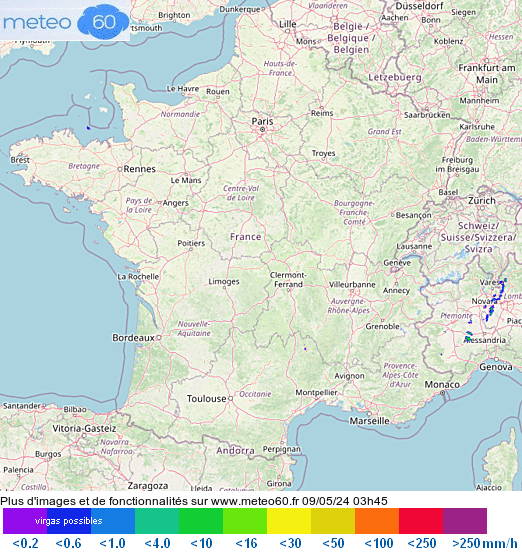
http://www.keraunos.org/previsions/prevision-crue-mediterranee-orage-cevenol.html
| BULLETIN DU MARDI 25 FÉVRIER 2014 |
VALIDITE : MAR 25 FEV 2014 06Z -> MER 26 FEV 2014 06Z
EMIS LE : 25/02/2014 A 08H LOC
EMIS LE : 25/02/2014 A 08H LOC
http://www.keraunos.org/assets/cartes/prevision-tornade-risque
European Storm Forecast Experiment
Storm Forecast
Storm Forecast
Valid: Tue 25 Feb 2014 06:00 to Wed 26 Feb 2014 06:00 UTC
Issued: Mon 24 Feb 2014 22:28
Forecaster: TUSCHY
Valid: Tue 25 Feb 2014 06:00 to Wed 26 Feb 2014 06:00 UTC
Issued: Mon 24 Feb 2014 22:28
Forecaster: TUSCHY
SYNOPSIS
Weak mid-layer height gradients with numerous large-scale vortices linger over S/C and E-Europe. A cyclonic vortex over N-Algeria rotates east and flattens over Sicily/Malta. A NW-SE elongated upper trough over SE-Europe offers no significant motion to the NE. Numerous cyclonic swirls mark the respective centers, which reform constantly on different places within the broad trough. Along with downstream ridging, blocking ridge-over-trough pattern persists over E-Europe.
Most active feature will be a slowly filling 970 hPa depression just north of Ireland. Attendant cold mid-layers overspread a vast area from N-Spain to Scotland during the night.
lundi 24 février 2014
2/24/2014 Ice Jam Damage Wildcat Creek Tippecanoe County, IN
http://www.youtube.com/watch?v=zrZaSrb_CnY
dimanche 23 février 2014
Tornado in Amberley, Canterbury, New Zealand! Plus some D
http://www.youtube.com/watch?v=FFNJqFc2kyY

samedi 22 février 2014
Weather warnings: Ireland
http://www.meteoalarm.eu/en_UK/0/0/IE-Ireland.html
http://earth.nullschool.net/#current/wind/surface/level/orthographic=345.27,49.95,1024
http://www.met.ie/
http://earth.nullschool.net/#current/wind/surface/level/orthographic=345.27,49.95,1024
http://www.met.ie/
vendredi 21 février 2014
Winter Won't Give Up: Bitter Cold Finish to February
http://www.weather.com/news/bitter-cold-finish-february-20140221

Aurora Forecast Yellowknife, Northwest Territories,,,,,,,,,,,,,,,,,,,,,http://www.asc-csa.gc.ca/eng/astronomy/auroramax/hd-480.asp
Friday, February 21
ACTIVE
| |
Activity Level: 6.0/10Early Aurora: 4.5/10
| |

INSANE close-range lightning strike!!! "Dixie Alley" Storm Chase
http://www.youtube.com/watch?v=sN0tOVlPGTw

jeudi 20 février 2014
European Storm Forecast Experiment
Storm Forecast
Storm Forecast
Valid: Fri 21 Feb 2014 06:00 to Sat 22 Feb 2014 06:00 UTC
Issued: Thu 20 Feb 2014 23:11
Forecaster: TUSCHY
Valid: Fri 21 Feb 2014 06:00 to Sat 22 Feb 2014 06:00 UTC
Issued: Thu 20 Feb 2014 23:11
Forecaster: TUSCHY
A level 1 was issued for Crete and the far S-Aegean Sea mainly for an isolated excessive rainfall event, isolated large hail and a few waterspouts. The level 1 was stretched far west to include a large hail risk over the SE Ionian Sea and extreme S-Greece.


mercredi 19 février 2014
Cocktail météo corsé vendredi
http://www.meteomedia.com/nouvelles/articles/redoux-avant-la-tempete-au-quebec/21549/
 in The colour Blue 15 + cm of snow
in Red freezing Rain
in green 15+ mm of rain
that s for friday.
in The colour Blue 15 + cm of snowin Red freezing Rain
in green 15+ mm of rain
that s for friday.
Messy winter system targets Quebec
http://www.theweathernetwork.com/news/articles/messy-winter-system-targets-quebec/21823/
More video
Heavy hail storm in Clackamas Oregon on February 19 2014
http://www.youtube.com/watch?v=wCAoXViwOXU

http://www.youtube.com/watch?v=wCAoXViwOXU

European Storm Forecast Experiment
Storm Forecast
Valid: Wed 19 Feb 2014 06:00 to Thu 20 Feb 2014 06:00 UTC
Issued: Wed 19 Feb 2014 00:49
Forecaster: PUCIK
Valid: Wed 19 Feb 2014 06:00 to Thu 20 Feb 2014 06:00 UTC
Issued: Wed 19 Feb 2014 00:49
Forecaster: PUCIK
A level 1 was issued for parts of western Italy, northern / northwestern Adriatics mainly for marginally large hail, severe wind gusts and to the lesser degree for excessive precipitation.
Storm Forecast
Storm Forecast
Valid: Thu 20 Feb 2014 06:00 to Fri 21 Feb 2014 06:00 UTC
Issued: Wed 19 Feb 2014 22:33
Forecaster: GATZEN
Valid: Thu 20 Feb 2014 06:00 to Fri 21 Feb 2014 06:00 UTC
Issued: Wed 19 Feb 2014 22:33
Forecaster: GATZEN
A level ! was issued for parts of the south Mediterranean Sea mainly for severe wind gusts, large hail, and tornadoes. http://www.estofex.org/

Severe Weather Outbreak, Including a Tornado Threat, Begins Thursday In the Ohio Valley, Southeast
http://www.weather.com/news/tornado-central/severe-weather-tracker-page

 http://www.spc.noaa.gov/products/outlook/day1otlk.html
http://www.spc.noaa.gov/products/outlook/day1otlk.html
mardi 18 février 2014
Winter Storm Rex Forecast: Snow for New England Through Tuesday Nigh
http://www.weather.com/news/winter-storm-rex-forecast-20140216
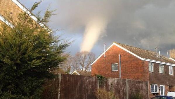 photo by
 http://www.spc.noaa.gov/products/
| This is the day after tomorrow's (day 3) forecast for organized severe thunderstorms over the contiguous United States. Please read the description of the risk categories for further information. The latest Day 3 Outlook is available as well as all Outlooks that have been issued today. Note: The 10% and greater probability thunder line is not included on the Day 3 Outlook. | Day 3 Outlook |
 | |
| This is the day 4-8 forecast for organized severe thunderstorms over the contiguous United States. The latest Day 4-8 Outlook is available as well as all Outlooks that have been issued today.Note: A severe weather area depicted in the Day 4-8 period indicates a 30% or higher probability for severe thunderstorms (e.g. a 30% chance that a severe thunderstorm will occur within 25 miles of any point). | Day 4-8 Outlook |
 |
lundi 17 février 2014
Winter Storm Rex Forecast: Snow, Ice from Midwest to Northeast
http://www.weather.com/safety/winter/winter-storm-rex-forecast-20140216


dimanche 16 février 2014
earth wind map,,,,,,,,,,,,,,,,,,,,,,,,,,,,,,,,,,,http://earth.nullschool.net/#current/wind/surface/level/orthographic=300.96,47.64,2048
Look at the map of winds in Newfoundland and Labrador,they are very strong,wow!
Public Weather Alerts for Newfoundland and Labrador,,,,,,,,,,,http://weather.gc.ca/warnings/index_e.html?prov=nl
Warnings
Strong southwesterly winds gusting to 120 km/h or stronger are expected tonight and to 100 km/h on Monday. Strong northwesterly winds gusting to 110 km/h are expected along parts of the Northeast Coast Monday night.This is a warning that blizzard conditions with near-zero visibilities are occurring in these regions. Monitor weather conditions

Travel chaos and power outages as powerful storm lashes Atlantic Canada
http://www.theweathernetwork.com/news/articles/travel-chaos-and-power-outages-as-powerful-storm-lashes-atlantic-canada/21620/


Inscription à :
Articles (Atom)