
samedi 31 mai 2014
May 31, 2014 1300 UTC Day 1 Convective Outlook,,,,,,,,,,,,,,,,,,,,,,,,,,,,,,,,,,,http://www.spc.noaa.gov/products/outlook/day1otlk.html

 DAY 1 CONVECTIVE OUTLOOK
 NWS STORM PREDICTION CENTER NORMAN OK 0730 AM CDT SAT MAY 31 2014 VALID 311300Z - 011200Z ...THERE IS A SLGT RISK OF SVR TSTMS ACROSS PARTS OF THE NRN AND CNTRL HIGH PLAINS... ...SUMMARY... ISOLATED TO SCATTERED SEVERE THUNDERSTORMS ARE EXPECTED ACROSS PORTIONS OF THE NORTHERN AND CENTRAL HIGH PLAINS FOR SATURDAY AFTERNOON AND EVENING. ...SYNOPSIS... THE PRIMARY FEATURE OF INTEREST DURING THE DAY ONE PERIOD IS A POSITIVELY TILTED SHORT-WAVE TROUGH WHICH WILL SLOWLY PROGRESS THROUGH THE NRN INTER-MOUNTAIN REGION AND GREAT BASIN. AT THE SURFACE...A LEE CYCLONE WILL DEEPEN TODAY OVER N-CNTRL WY WHILE AN ASSOCIATED WEAK FRONT DEVELOPS NWD THROUGH WY AND WRN SD. A LEE TROUGH WILL EXTEND GENERALLY SWD FROM THE LOW THROUGH ERN PARTS OF WY...CO...AND NM BY MID TO LATE AFTERNOON.
vendredi 30 mai 2014
| This is tomorrow's forecast for organized severe thunderstorms over the contiguous United States. Please read the description of the risk categories for further information. The latest Day 2 Outlook is available as well as all Outlooks that have been issued today. | Tomorrow's Outlook |
 | |
| This is the day after tomorrow's (day 3) forecast for organized severe thunderstorms over the contiguous United States. Please read the description of the risk categories for further information. The latest Day 3 Outlook is available as well as all Outlooks that have been issued today. | Day 3 Outlook |
 |
European Storm Forecast Experiment
Storm Forecast
Storm Forecast
Valid: Sat 31 May 2014 06:00 to Sun 01 Jun 2014 06:00 UTC
Issued: Fri 30 May 2014 23:39
Forecaster: PISTOTNIK
Valid: Sat 31 May 2014 06:00 to Sun 01 Jun 2014 06:00 UTC
Issued: Fri 30 May 2014 23:39
Forecaster: PISTOTNIK
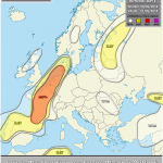
A level 1 was issued for W-most Russia, E Belarus and large parts of the Ukraine mainly for excessive precipitation and large hail.
A level 1 was issued for Moldova and E Romania mainly for excessive precipitation.
A level 1 was issued for the NE Aegean region mainly for excessive precipitation and waterspouts.
A level 1 was issued for parts of Italy mainly for large hail, excessive precipitation and waterspouts.
A level 1 was issued for SE France mainly for large hail and excessive precipitation.
A level 1 was issued for SE Spain, NE Algeria and N Tunisia for large hail and to a lesser extent for severe wind gusts.
SYNOPSIS
Low geopotential and rather cool air masses continue to affect most of Europe. The dominant upper-level low over Finland will re-connect with the Northern branch of the main frontal zone on Saturday. Another belt of several small upper-level lows stretches from Spain across the Southern Alpine region into Romania. In-between, weak ridging from the Atlantic Ocean extends over the British Isles into Germany.
Near the surface, fairly high pressure over the Western half of Europe is opposed by a filling low over Finland and a deepening low that moves from the Western Black Sea northward into the Ukraine. Ahead of these two cyclones, warm air advection overspreads the Ukraine, Belarus and Western Russia.


jeudi 29 mai 2014

May 29, 2014 2000 UTC Day 1 Convective Outlook,,,,,,,,,,,,,,,,,,,,,,,,,,http://www.spc.noaa.gov/products/outlook/day1otlk.html

 DAY 1 CONVECTIVE OUTLOOK
 NWS STORM PREDICTION CENTER NORMAN OK 0300 PM CDT THU MAY 29 2014 VALID 292000Z - 301200Z ...THERE IS A SLGT RISK OF SVR TSTMS OVER PORTIONS OF THE WESTERN DAKOTAS... ...SUMMARY... A FEW SEVERE THUNDERSTORMS WILL BE POSSIBLE OVER THE NORTHERN PLAINS LATE THIS AFTERNOON AND EVENING...WITH MORE ISOLATED SEVERE STORMS POSSIBLE OVER THE LOWER MISSISSIPPI VALLEY/CENTRAL GULF COAST REGION AND THE CAROLINAS. LATEST VISIBLE IMAGERY SUGGESTS THAT THE CUMULUS FIELD ALONG A COLD FRONT EXTENDING SOUTHWARD ACROSS THE MT-ND BORDER AND INTO CENTRAL WYOMING CONTINUES TO BECOME BETTER DEFINED...AND ADDITIONAL THUNDERSTORM DEVELOPMENT IS EXPECTED OVER THE NEXT FEW HOURS ACROSS PORTIONS OF THE WESTERN DAKOTAS SOUTHWARD INTO NORTHERN/EASTERN WYOMING. DAMAGING WINDS AND LARGE HAIL WILL BE THE PRIMARY THREATS. REF SWOMCD 754 FOR THE LATEST SHORT-TERM THINKING IN THIS AREA. MINOR WESTWARD ADJUSTMENTS WERE MADE TO THE 5 PERCENT WIND PROBABILITY OVER EASTERN TENNESSEE AND TO THE GENERAL THUNDER LINE OVER WESTERN VIRGINIA BASED ON CURRENT AND EXPECTED SHORT-TERM TRENDS. OTHERWISE THE PREVIOUS OUTLOOK REMAINS ON TRACK AND NO SIGNIFICANT CHANGES WERE MADE.
| Mesoscale Discussion 757 | |
| < Previous MD | |
 | |
MESOSCALE DISCUSSION 0757 NWS STORM PREDICTION CENTER NORMAN OK 0625 PM CDT THU MAY 29 2014 AREAS AFFECTED...WRN DAKOTAS...FAR NE WY CONCERNING...SEVERE THUNDERSTORM WATCH 198... VALID 292325Z - 300030Z THE SEVERE WEATHER THREAT FOR SEVERE THUNDERSTORM WATCH 198 CONTINUES. SUMMARY...TSTMS...SOME SVR...ARE EXPECTED TO PERSIST ALONG A COLD FRONT MOVING EWD ACROSS THE WRN DAKOTAS. LARGE HAIL AND DAMAGING WINDS ARE POSSIBLE. DISCUSSION...A COLD FRONT EXTENDS SWD ACROSS WRN ND AND INTO FAR NW WY. CORRIDOR OF NARROW INSTABILITY AHEAD OF THE COLD FRONT CONTINUES TO FAVOR TSTM DEVELOPMENT WITH SOME STORMS CAPABLE OF SVR HAIL NOTED ACROSS SW ND. STORMS ACROSS ND ARE EXPECTED TO CONTINUE GRADUALLY EWD INTO A MORE STABLE ENVIRONMENT. ADDITIONALLY...SLOW EWD MOTION -- RESULTANT FROM THE BULK SHEAR VECTOR ORIENTATED PARALLEL TO THE FRONTAL BOUNDARY -- WILL RESULT IN THE COLD FRONT UNDERCUTTING ONGOING STORMS. THESE FACTORS WILL LIKELY RESULT IN GRADUALLY WEAKENING STORMS. MOST MODEL GUIDANCE CORROBORATES THIS SCENARIO ACROSS ND. FARTHER S ACROSS WRN SD AND FAR NERN WY...TSTMS ARE EXPECTED TO PERSIST WITH SOME INCREASE IN COVERAGE POSSIBLE OVER THE NEXT HOUR OR TWO. FRONTAL BOUNDARY EXTENDS MORE SWWD ACROSS CNTRL WY WITH THE BULK SHEAR VECTOR ACROSS THIS AREA ALIGNED LESS ALONG THE BOUNDARY THAN FARTHER N. AS A RESULT...A SUPERCELL OR TWO MAY BE ABLE TO PERSIST LONGER ACROSS THIS REGION. HOWEVER...LOW-LEVEL MOISTURE HAS MIXED OUT ACROSS THIS REGION....LIMITING OVERALL INSTABILITY AND STORM STRENGTH. CURRENT RADAR IMAGERY SUGGESTS MOST OF THE ONGOING ACTIVITY REMAINS ALONG OR JUST BEHIND THE BOUNDARY. ..MOSIER.. 05/29/2014 | |


mercredi 28 mai 2014
European Storm Forecast Experiment,,,,,,,,,,,,,,,,,,,,,,,,,,,,,,http://www.estofex.org/
Storm Forecast
Storm Forecast
Valid: Thu 29 May 2014 06:00 to Fri 30 May 2014 06:00 UTC
Issued: Wed 28 May 2014 23:51
Forecaster: GATZEN
Valid: Thu 29 May 2014 06:00 to Fri 30 May 2014 06:00 UTC
Issued: Wed 28 May 2014 23:51
Forecaster: GATZEN
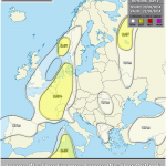
A level 2 was issued for southern Greece and western Turkey mainly for very large hail and severe wind gusts.
A level 1 was issued for the Aegean region mainly for large hail, severe wind gusts, tornadoes, and excessive precipitation.
A level 1 was issued for north-western Turkey and eastern Bulgaria mainly for large hail and tornadoes.
A level 1 was issued for the northern Ukraine and western Russia/eastern Belarus mainly for large hail and excessive precipitation.
SYNOPSIS
A large trough covers Europe, pushing the polar jet stream to Spain, the south Mediterranean, and Turkey that is affected by a strong mid-level jet streak on Thursday. Over northern Europe, a polar trough is located over the Baltic Sea just west of a high pressure system over the North Sea. Cold and dry air masses will spread into central Europe.
http://www.spc.noaa.gov/products/md/
| Current Mesoscale Discussions Updated: Wed May 28 21:13:03 UTC 2014  |

May 28, 2014 2000 UTC Day 1 Convective Outlook,,,,,,,,,,,,,,,,,,,,,,,,,,,,,,,,,,,,,,,,http://www.spc.noaa.gov/products/outlook/day1otlk.html
DAY 1 CONVECTIVE OUTLOOK NWS STORM PREDICTION CENTER NORMAN OK 0237 PM CDT WED MAY 28 2014 VALID 282000Z - 291200Z ...THERE IS A SLGT RISK OF SVR TSTMS ACROSS PORTIONS OF THE NRN PLAINS... ...THERE IS A SLGT RISK OF SVR TSTMS OVER PARTS OF THE LOWER MS VALLEY... ...SUMMARY... SEVERE THUNDERSTORMS CAPABLE OF LARGE HAIL...DAMAGING WIND AND TORNADOES MAY AFFECT PARTS OF MONTANA AND WESTERN NORTH DAKOTA LATE THIS AFTERNOON INTO TONIGHT. ISOLATED SEVERE THUNDERSTORMS ALSO MAY OCCUR ALONG THE CENTRAL GULF COAST. ELSEWHERE...SCATTERED STRONG TO MARGINALLY SEVERE STORMS MAY OCCUR OVER PARTS OF FLORIDA...THE OHIO VALLEY...THE MID-ATLANTIC STATES...AND THE EASTERN GREAT BASIN.
Public Weather Alerts for Alberta,,,,,,,,,,,,,,,,http://weather.gc.ca/warnings/index_e.html?prov=ab
Watches
- Co. of Forty Mile near Aden and Kennedy Coulee
- Co. of Forty Mile near Etzikom and Maleb
- Co. of Forty Mile near Foremost
- Co. of Forty Mile near Orion and Manyberries
- Cypress Co. near Cypress Hills Prov. Park and Cressday
- Cypress Co. near Onefour and Wild Horse
Severe thunderstorm conditions possible - afternoon to evening.
Conditions are favourable for the development of dangerous thunderstorms that may be capable of producing strong wind gusts, damaging hail and heavy rain.
A low pressure system and advancing warm front in Montana will push into southeastern Alberta today likely triggering severe thunderstorms later this afternoon into this evening.
Very large hail can damage property, break windows, dent vehicles and cause serious injury. Strong wind gusts can toss loose objects, damage weak buildings, break branches off trees and overturn large vehicles. Remember, severe thunderstorms can produce tornadoes. Be prepared for severe weather. Take cover immediately, if threatening weather approaches. In Canada, lightning kills up to 10 people every year. Remember, when thunder roars, go indoors.
Environment Canada meteorologists will update alerts as required. Please continue to monitor your local media or Weatheradio for further updates. If you would like to report severe weather, you can call 1-800-239-0484 or send an email to storm@ec.gc.ca or tweet reports to #ABStorm.
Environment Canada meteorologists will update alerts as required. Please continue to monitor your local media or Weatheradio for further updates. If you would like to report severe weather, you can call 1-800-239-0484 or send an email to storm@ec.gc.ca or tweet reports to #ABStorm.
http://weather.gc.ca/warnings/index_e.html?prov=sk
Public Weather Alerts for Saskatchewan
Tornado watch in effect for:
Tornado conditions possible - late afternoon to after midnight.
Conditions are favourable for the development of severe thunderstorms which may produce tornadoes.
A low pressure system and advancing warm front in Montana will push into southern Saskatchewan today likely triggering severe thunderstoms later this afternoon into this evening over southwest Saskatchewan. There is a potential that some of these storms may produce tornadoes at the onset of the event. The potential for large hail and damaging winds will also exist and will continue into the evening as thunderstorms continue to track to the east tonight. The severe thunderstorm threat may spread into southeast Saskatchewan overnight and watches may be expanded east later today.
Be prepared for severe weather. Take cover immediately, if threatening weather approaches.
In the event of a tornado, or if a tornado warning is issued for your area, it is recommended you take the following actions: Go indoors to a room on the lowest floor, away from outside walls and windows, such as a basement, bathroom, stairwell or interior closet. Leave mobile homes, vehicles, tents, trailers and other temporary or free-standing shelter, and move to a strong building if you can. As a last resort, lie in a low spot and protect your head from flying debris.
Environment Canada meteorologists will update alerts as required. Please continue to monitor your local media or Weatheradio for further updates. If you would like to report severe weather, you can call 1-800-239-0484 or send an email to storm@ec.gc.ca or tweet reports to #SKStorm.

mardi 27 mai 2014
lundi 26 mai 2014
May 26, 2014 0600 UTC Day 1 Convective Outlook,,,,,,,,,,,,,,,,http://www.spc.noaa.gov/products/outlook/day1otlk.html

 DAY 1 CONVECTIVE OUTLOOK
 NWS STORM PREDICTION CENTER NORMAN OK 1158 PM CDT SUN MAY 25 2014 VALID 261200Z - 271200Z ...THERE IS A SLGT RISK OF SVR TSTMS A LARGE PORTION OF W TX...FAR SWRN OK... ...SUMMARY... SEVERE THUNDERSTORMS WILL BE POSSIBLE ACROSS A LARGE PORTION OF WESTERN TEXAS INTO FAR SOUTHWESTERN OKLAHOMA...MAINLY DURING THE AFTERNOON AND EVENING. ELSEWHERE...STRONG STORMS WILL BE POSSIBLE ACROSS PARTS OF THE NORTHERN HIGH PLAINS...THE UPPER MIDWEST...AND PORTIONS OF NEW ENGLAND. ...SYNOPSIS... A SPLIT FLOW REGIME ACROSS THE CONUS WILL FEATURE A SRN STREAM CLOSED LOW SLOWLY PROGRESSING EWD ACROSS THE SRN PLAINS. STRONGER FLOW ALOFT ACCOMPANYING A SHORTWAVE TROUGH WILL OVERSPREAD THE PAC NW AND NRN ROCKIES. FARTHER DOWNSTREAM...UPPER RIDGE WILL SHIFT E OF THE MS VALLEY...WHILE BROADLY CYCLONIC FLOW PERSISTS ACROSS THE NORTHEAST. ...PARTS OF W AND S TX.. AN UPPER IMPULSE NOTED IN EARLY MORNING WATER VAPOR IMAGERY WAS MOVING EWD ACROSS NWRN MX...AND IS FORECAST TO REACH THE TX BIG BEND AREA BY MID-MORNING MON. UNCERTAINTY EXISTS ABOUT THE PREVALANCE OF CONVECTION DEVELOPING IN CONJUNCTION WITH THIS FEATURE ACROSS W/W-CNTRL TX...WHICH WILL HAVE IMPLICATIONS ON POSITION OF KEY MESOSCALE FEATURES /E.G. OUTFLOW BOUNDARIES/. A SLIGHT EWD DISPLACEMENT OF THE PERSISTENT CLOSED MID/UPPER-LEVEL LOW INTO THE SRN HIGH PLAINS WILL OCCUR. MIDLEVEL SWLYS ATTENDANT TO SURROUNDING AREA OF CYCLONIC FLOW ARE FORECAST TO BE SLIGHTLY STRONGER TODAY THAN PREVIOUS DAYS /E.G. 40 KTS AT 500 MB/. A MOIST BOUNDARY LAYER IS ALREADY IN PLACE...AND WITH AT LEAST MODEST SFC HEATING /TEMPS 70S-80S F/...MLCAPE VALUES RANGING FROM 1000-2000 J/KG APPEAR LIKELY IN AREAS UNPERTURBED BY MORNING CONVECTION. AMPLE DEEP-LAYER SHEAR OF 35-45 KT WILL BE IN PLACE TO SUPPORT SUPERCELLS. CONVECTIVE INITIATION WILL LIKELY BE FOCUSED ALONG PREEXISTING OUTFLOW BOUNDARIES INVOF THE TX PERMIAN BASIN/EDWARDS PLATEAU TOWARDS THE MIDDLE RIO GRANDE VALLEY. A SHARPER MOISTURE GRADIENT/DRYLINE WILL ALSO EXIST ACROSS THE TX PANHANDLE INTO ERN NM...AND SHOULD SUPPORT ADDITIONAL CONVECTIVE DEVELOPMENT IN CONJUNCTION WITH LARGER-SCALE ASCENT ATTENDANT TO THE UPPER LOW...CONTINGENT ON SUFFICIENT DESTABILIZATION. PRIMARY SVR THREAT IS EXPECTED TO REMAIN LARGE HAIL GIVEN THE PRESENCE OF STEEP MIDLEVEL LAPSE RATES AND GENERALLY WEAK LOW-LEVEL FLOW. HOWEVER...THE RISK FOR A TORNADO OR TWO MAY EXIST WITH SUPERCELLS THAT INTERACT FAVORABLY WITH OUTFLOW BOUNDARIES. LOCALLY DMGG WINDS ARE ALSO POSSIBLE.
dimanche 25 mai 2014
http://www.spc.noaa.gov/products/watch/
| Current Convective Watches (View What is a Watch? clip) Updated: Sun May 25 20:39:07 UTC 2014   |
Public Weather Alerts for Quebec - south,,,,,,,,,,,,,,,,,,,,,,,,,,,,,http://weather.gc.ca/warnings/index_e.html?prov=sqc
 Severe thunderstorm conditions possible - afternoon to early evening.
Conditions are favourable for the development of severe thunderstorms that may be capable of producing strong wind gusts, large hail and heavy rain.
An unstable air mass is lying over Central and Southern Quebec today. Thunderstorms will develop this afternoon and early this evening. Some of them could reach severe limits. The thunderstorms will ease early this evening.
Large hail can damage property and cause injury. Strong wind gusts can toss loose objects, damage weak buildings, break branches off trees and overturn large vehicles. Remember, severe thunderstorms can produce tornadoes. Be prepared for severe weather. Take cover immediately, if threatening weather approaches. Stay indoors when a thunderstorm strikes. There isn't a place outside that is safe during a thunderstorm. Stay away from all windows, skylights and doors. In Canada, lightning kills up to 10 people every year. Remember, when thunder roars, go indoors.
Environment Canada meteorologists will update alerts as required. Please continue to monitor your local media or Weatheradio for further updates. If you would like to report severe weather, you can call 1-800-361-0233 or send an email to tempsviolent.quebec@ec.gc.ca. You may also tweet reports of severe weather to #meteoqc.
Environment Canada meteorologists will update alerts as required. Please continue to monitor your local media or Weatheradio for further updates. If you would like to report severe weather, you can call 1-800-361-0233 or send an email to tempsviolent.quebec@ec.gc.ca. You may also tweet reports of severe weather to #meteoqc.

May 25, 2014 0100 UTC Day 1 Convective Outlook


   DAY 1 CONVECTIVE OUTLOOK
   NWS STORM PREDICTION CENTER NORMAN OK
   0800 PM CDT SAT MAY 24 2014

   VALID 250100Z - 251200Z

   ...THERE IS A SLGT RISK OF SVR TSTMS ACROSS THE SOUTHERN HIGH
   PLAINS...

   ...SUMMARY...
   SEVERE THUNDERSTORMS WILL REMAIN POSSIBLE TONIGHT MAINLY ACROSS THE
   SOUTHERN HIGH PLAINS...INCLUDING PORTIONS OF EASTERN NEW
   MEXICO...AND WEST/SOUTHWEST TEXAS.

   ...EASTERN NM AND WEST/SOUTHWEST TX...
   A LOOSELY ORGANIZED CLUSTER OF SEVERE TSTMS/EMBEDDED SUPERCELLS ARE
   ONGOING AT MID-EVENING ACROSS PARTS OF THE PERMIAN BASIN/STOCKTON
   PLATEAU/EDWARDS PLATEAU OF SOUTHWEST TX. BOUTS OF LARGE HAIL/LOCALLY
   DAMAGING WINDS AND SOME TORNADO RISK WILL CONTINUE MAINLY OVER THE
   NEXT FEW HOURS THIS EVENING. FOR ADDITIONAL SHORT-TERM DETAILS...SEE
   MESOSCALE DISCUSSION 686.

   CONVECTIVE OUTFLOW IS OTHERWISE STEADILY PROGRESSING
   SOUTH/SOUTHWESTWARD ACROSS FAR SOUTHWEST TX AND SOUTHEAST NM THIS
   EVENING. AN INCREASINGLY STRONG SOUTHERLY LOW-LEVEL JET AND AN
   EJECTING IMPULSE/JET STREAK ON THE SOUTH/SOUTHEAST PERIPHERY OF THE
   SOUTHERN ROCKIES UPPER LOW MAY INSPIRE ADDITIONAL STRONG/SEVERE TSTM
   DEVELOPMENT TONIGHT ACROSS EASTERN NM INTO WEST/SOUTHWEST TX. BOUTS
   OF SEVERE HAIL WOULD BE THE PRIMARY CONCERN...AS A RELATIVELY
   UNSTABLE AIR MASS REMAINS /SHALLOW OUTFLOW OUTSIDE/ ACROSS THE
   REGION AS SAMPLED PER THE 00Z MIDLAND OBSERVED SOUNDING.

jeudi 22 mai 2014

European Storm Forecast Experiment
Storm Forecast
Storm Forecast
Valid: Fri 23 May 2014 06:00 to Sat 24 May 2014 06:00 UTC
Issued: Thu 22 May 2014 21:20
Forecaster: TUSCHY
Valid: Fri 23 May 2014 06:00 to Sat 24 May 2014 06:00 UTC
Issued: Thu 22 May 2014 21:20
Forecaster: TUSCHY
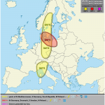
A level 1 was issued for E/SE Germany, W-Poland the Czech Republic and parts of Austria mainly for large hail (an isolated very large hail event can't be excluded), strong to isolated severe wind gusts, excessive rain and an isolated tornado event.
A level 1 was issued for SE-Norway and SW Sweden mainly for an isolated large hail event.
A level 1 was issued for CNTRL UK mainly for an isolated tornado event.
A level 1 was issued for parts of France, Belgium, far W-Germany and Luxembourg mainly for an isolated large hail and strong wind gusts event. A tornado or two are possible.
A level 1 was issued for parts of Italy, Slovenia and Croatia mainly for large hail (an isolated very large hail event is possible) and strong to severe wind gusts. Excessive rain accompanies storm clusters over N-Italy.
A level 1 was issued for parts of N-Tunisia mainly for an isolated large hail event.
A level 1 was issued for parts of SW-Turkey mainly for an isolated large hail event.
SYNOPSIS
The rotation center of a big cyclonic vortex remains just offshore of SW UK . Numerous impulses within its periphery affect NW Europe with the strongest one crossing France during the day from SW to NE. Another upper low is situated over SE Europe with weak ridging in between.
At lower levels, a pronounced front bisects Europe with cool and modified marine air to its west and warm/moist air to its east. This front moves leisurely to the east and becomes quasi-stationary during the overnight hours roughly from Sweden to E-Austria to Sicily. Another Atlantic front affects W/NW France with enhanced thunderstorm chances.
mercredi 21 mai 2014
European Storm Forecast Experiment,,,,,,,,,,,,,,,,,,,,,,,,,,,,,,,,,,,,,,,,,http://www.estofex.org/
Storm Forecast
Storm Forecast
Valid: Thu 22 May 2014 06:00 to Fri 23 May 2014 06:00 UTC
Issued: Wed 21 May 2014 22:24
Forecaster: GATZEN
Valid: Thu 22 May 2014 06:00 to Fri 23 May 2014 06:00 UTC
Issued: Wed 21 May 2014 22:24
Forecaster: GATZEN
A level 1 was issued for southern Germany mainly for large hail.
A level 1 was issued for central and northern Germany and Denmark mainly for severe wind gusts and large hail.
A level 1 was issued for eastern France, Benelux, and south-eastern British Isles mainly for tornadoes and severe wind gusts.
A level 1 wa issued for western Germany mainly for severe wind gusts.
A level 1 was issued for Sardinia, Corsica and Tunisia mainly for large hail and excessive precipitation.
A level 1 was issued for eastern Ukraine, Romania, and Bulgaria mainly for excessive precipitation and large hail.
A level 1 was issued for north-western Russia mainly for large hail and severe wind gusts.
SYNOPSIS
A deep trough is quasi-stationary across western Europe. A strong south-southwesterly flow will persist from the west Mediterranean Sea to the Benelux countries and western Scandinavia. A ridge extends from the central Mediterranean towards the Baltic Sea and Belarus/Russia. It is flanked by a Black Sea trough and a short-wave trough moving north-eastwards across northern Russia.

Inscription à :
Commentaires (Atom)