mercredi 30 avril 2014

European Storm Forecast Experiment

Storm Forecast
Storm Forecast
Valid: Thu 01 May 2014 06:00 to Fri 02 May 2014 06:00 UTC
Issued: Wed 30 Apr 2014 23:36
Forecaster: GATZEN
A level 1 was issued for the central Balkans mainly for excessive precipitation.

A level 1 was issued for the northern Aegean mainly for large hail.

SYNOPSIS

Weak geopotential is present across Europe, and the jet stream extends from the Bay of Biscay towards the Mediterranean Sea. Two vort-maxima will travel within the jet, one from Italy to Turkey, the other from the Bay of Biscay to the west Mediterranean Sea. Due to limited moisture over the Mediterranean, CAPE will be rather weak. Further north, moist and well-mixed air masses are still present from western into central and eastern Europe. Widespread convection will result during the period. Colder and dry air masses start to spread south from Scandinavia.

DISCUSSION

Greece, Aegean region

A short-wave trough moves east during the day, providing DCVA. The affected air mass is expected to become unstable in response to diurnal heating over Greece and onshore advection of modest moisture. Near the trough axis, initiation will be most likely, but weak vertical wind shear will limit storm organization. The best potential will therefore exist across the Aegean region, where an ageostrophic flow will evolve ahead of the vort-max. More than 20 m/s deep layer vertical wind shear are expected by latest GFS model run in the evening hours. Multicells and supercells may be capable of producing large hail. Given weak low-level vertical wind shear, tornadoes are rather unlikely.
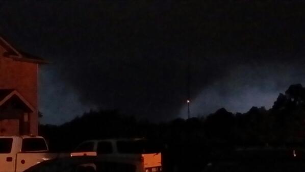
Tromba d'aria Nonantola 30.04.2014

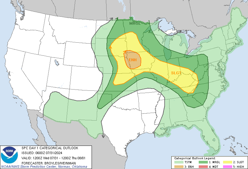
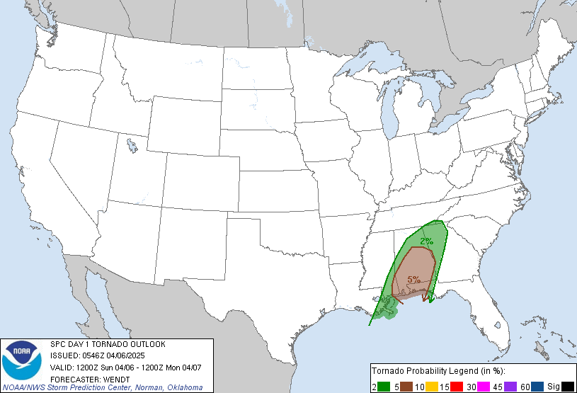
Apr 30, 2014 0600 UTC Day 1 Convective Outlook

DAY 1 CONVECTIVE OUTLOOK  
   NWS STORM PREDICTION CENTER NORMAN OK
   0100 AM CDT WED APR 30 2014

   VALID 301200Z - 011200Z

   ...THERE IS A SLGT RISK OF SVR TSTMS FROM VA/MD/WV SWD TO THE FL
   GULF COAST...

   ...SUMMARY...
   SEVERE THUNDERSTORMS CAPABLE OF HAIL...DAMAGING WINDS...AND
   TORNADOES ARE EXPECTED WEDNESDAY ACROSS PORTIONS OF THE SOUTHEAST
   UNITED STATES...CAROLINAS...AND MID-ATLANTIC STATES.

   ...SYNOPSIS...
   A LARGE/PERSISTENT MID- AND UPPER-LEVEL LOW WILL MAKE SLOW EWD
   PROGRESS ACROSS THE UPPER MIDWEST THIS PERIOD...WHILE STRONG
   CYCLONIC FLOW SURROUNDING THE LOW BEGINS SPREADING ACROSS THE
   APPALACHIANS -- ESPECIALLY DURING THE SECOND HALF OF THE PERIOD. 
   ELSEWHERE...RIDGING WILL PERSIST BOTH UPSTREAM AND DOWNSTREAM OF THE
   LOW -- I.E. ACROSS THE W COAST STATES AND OVER THE WRN ATLANTIC/NEW
   ENGLAND -- THROUGH THE PERIOD.

   AT THE SURFACE...A COLD FRONT TRAILING FROM A NEARLY STATIONARY
   OCCLUDED LOW OVER THE WI VICINITY IS PROGGED TO ADVANCE ACROSS THE
   APPALACHIANS BY LATE AFTERNOON...AND THEN CONTINUE SLOWLY EWD ACROSS
   THE E COAST STATES OVERNIGHT.  WIDESPREAD THUNDERSTORMS AND
   ASSOCIATED SEVERE POTENTIAL CAN BE EXPECTED NEAR AND E OF THE
   MOUNTAINS.

   ...MID-ATLANTIC/EAST COAST STATES AND VICINITY...
   THUNDERSTORMS ARE FORECAST TO BE ONGOING ACROSS PORTIONS OF THE
   SLIGHT RISK AREA AT THE START OF THE PERIOD...INCLUDING THE FL
   PANHANDLE REGION/N FL AND INTO SRN GA WHERE AN MCS SHOULD BE
   ONGOING.  WITH ASSOCIATED CLOUDS AND PRECIPITATION LIKELY TO LIMIT
   AIRMASS DESTABILIZATION POTENTIAL IN MANY AREAS...EXPECT OVERALL
   SEVERE RISK TO BE SOMEWHAT HINDERED BY A
   SOMEWHAT-LESS-THAN-FAVORABLE THERMODYNAMIC ENVIRONMENT.  THAT
   SAID...WEAK HEIGHT FALLS SPREADING ACROSS THE AREA PROVIDING
   BACKGROUND UVV SHOULD HELP FOCUS AREAS OF LOW-LEVEL
   CONVERGENCE/ASCENT...FUELING A DIURNAL INCREASE IN STORM COVERAGE. 
   MEANWHILE...STRONGER FLOW ALOFT GRADUALLY SPREADING EWD ATOP
   LOW-LEVEL SLYS WILL RESULT SHEAR PROFILES SUPPORTIVE OF
   ORGANIZED/ROTATING STORMS.  THUS -- WHILE TEMPERED BY GENERALLY
   MODEST CAPE...EXPECT SEVERAL BANDS OF STORMS TO CROSS THE SLIGHT
   RISK AREA THROUGH THE DAY -- ALONG WITH ASSOCIATED RISK FOR DAMAGING
   WINDS AND SOME HAIL.  IN ADDITION...WITH VEERING/INCREASING FLOW
   THROUGH THE LOWEST FEW KM...SOME RISK FOR TORNADOES IS ALSO EVIDENT.
    RISK FOR SEVERE WEATHER -- THOUGH DECREASING SOME AFTER SUNSET --
   SHOULD CONTINUE THROUGH THE EVENING AND INTO THE OVERNIGHT HOURS AS
   THE COLD FRONT CROSSES THE MOUNTAINS AND SHIFTS EWD ACROSS THE RISK
   AREA.

mardi 29 avril 2014

European Storm Forecast Experiment

Storm Forecast
Storm Forecast
Valid: Tue 29 Apr 2014 06:00 to Wed 30 Apr 2014 06:00 UTC
Issued: Mon 28 Apr 2014 21:26
Forecaster: PISTOTNIK
A level 1 was issued for a belt from the Netherlands towards the Balkans mainly for excessive precipitation and to a lesser extent for large hail.

A level 1 was issued for a belt from S Italy towards the Turkish West coast mainly for large hail and waterspouts.

A level 1 was issued for Central France for severe wind gusts and tornadoes.

SYNOPSIS

The main frontal zone is distinctly split into two branches, the Southern one running across the Mediterranean region and the Northern one across Scandinavia. In-between, rather low geopotential and weak gradients cover most of Europe. Two upper-level lows are moving from the Channel towards S France and from Central Italy to the Aegean Sea, creating an elongated stretch of unsettled and cool conditions. Warmer but equally moist air is present over Central Europe and over the Balkans, where a broad minimum of surface pressure has formed.
Weak anticyclonic influence creates dry and brighter conditions over Northeastern Europe. However, in the far North a cyclone moves from Finland into adjacent Russia, and a surge of polar air will enter most of Scandinavia in its wake.

April 28th, 2014: Supercell & Large Tornado near Columbus, MS

tornado warning!!! Wilmington, NC Radar

Click for latest Long Range Base Reflectivity radar image from the Wilmington, NC radar and current weather warnings

tornado warning!!!!Birmingham, AL Radar

Click for latest Long Range Base Reflectivity radar image from the Birmingham, AL radar and current weather warnings

http://www.weather.com/tv/tvshows/live-stream


LIVESTREAM

http://www.spc.noaa.gov/products/watch/

Current Convective Watches (View What is a Watch? clip)
Updated:  Tue Apr 29 22:16:08 UTC 2014

Valid WW Image WW Graphics Legend

Tornado Warning!!! Raleigh/Durham, NC Radar

Click for latest Composite Reflectivity radar image from the Raleigh/Durham, NC radar and current weather warnings

Apr 29, 2014 0600 UTC Day 1 Convective Outlook,,,,,,,,,,,,,,,,,,,,,,,,,,,,,http://www.spc.noaa.gov/products/outlook/day1otlk.html

VALID 291200Z - 301200Z
   ...THERE IS A MDT RISK OF SVR TSTMS ACROSS PORTIONS OF AL AND ERN
   MS...

   ...THERE IS A SLGT RISK OF SVR TSTMS ACROSS A LARGE PORTION OF THE
   ERN U.S. E OF THE MS VALLEY...

   ...SUMMARY...
   WIDESPREAD THUNDERSTORMS ARE FORECAST ACROSS THE CENTRAL GULF COAST
   REGION...WITH SEVERAL SEVERE/SUPERCELL STORMS POSSIBLE -- ALONG WITH
   ATTENDANT RISK FOR HAIL...DAMAGING WINDS...AND TORNADOES. 
   STRONG/SEVERE STORMS ARE ALSO EXPECTED ACROSS SOUTHERN VIRGINIA AND
   THE CAROLINAS...WHERE HAIL AND DAMAGING WINDS ARE EXPECTED ALONG
   WITH THE POTENTIAL FOR A TORNADO OR TWO.  SHOWERS AND ISOLATED
   THUNDERSTORMS -- ALONG WITH RISK FOR HAIL AND LOCALLY DAMAGING WINDS
   -- WILL ALSO DEVELOP ACROSS PARTS OF THE MID OHIO VALLEY AND NORTH
   INTO SOUTHERN LOWER MICHIGAN DURING THE AFTERNOON.

   ...SYNOPSIS...
   A LARGE MID- AND UPPER-LEVEL LOW OVER THE LOWER MO VALLEY VICINITY
   WILL DRIFT SLOWLY NWD WITH TIME...WITH A BROAD ZONE OF STRONG
   CYCLONIC FLOW SURROUNDING THIS SYSTEM.  AT THE SURFACE...AN OCCLUDED
   LOW IS PROGGED TO LINGER INVOF THE ERN IA/NRN IL VICINITY MUCH OF
   THE PERIOD...WITH A TRAILING COLD FRONT TO MAKE SLOW EWD PROGRESS
   ACROSS THE MID OH AND TN VALLEYS/CENTRAL GULF COAST REGION.  AREAS
   AHEAD OF THIS BOUNDARY WILL AGAIN FALL UNDER A RISK FOR FAIRLY
   WIDESPREAD SEVERE STORMS.

Click for more maps
Click map for watches

MASSIVE TORNADO - Louisville Mississippi - April 28, 2014

April 28, 2014 Large Louisville, Mississippi Tornado - Dashcam

lundi 28 avril 2014

Severe Storms LIVE Stream - USA Tornado Chase

https://www.youtube.com/watch?v=xBGhE4ns3K0

Huge wedge tornado near Columbus, MS on April 28, 2014

WATCH LIVE: TORNADO EMERGENCY FOR ALABAMA

http://www.weather.com/tv/tvshows/live-stream

Mobile, AL Radar

Click for latest Base Reflectivity radar image from the Mobile, AL radar and current weather warnings

Columbus Air Force Base, MS Radar

Click for latest Base Reflectivity radar image from the Columbus Air Force Base, MS radar and current weather warnings

NOAA Weather Radio

http://www.wunderground.com/wxradio/

04-28-14 Stephen Jones Louisville, MS Tornado

https://www.youtube.com/watch?v=VSYz_7OvQ38&feature=youtu.be&a

April 28, 2014: Yazoo County Tornado Chase

Brandon/Jackson, MS Radar

Click for latest Base Reflectivity radar image from the Brandon/Jackson, MS radar and current weather warnings

http://www.severestudios.com/livechase

STORM CHASERS LIVE NOW Daniel Shaw weat of Colombus 

Massive Tornado

Logo  Brett Adair and also David D and ...

Huntsville Radar

Click for latest Base Reflectivity radar image from the Huntsville radar and current weather warnings

http://www.weather.com/tv/tvshows/live-stream

4/28/2014 Yazoo City, MS - Live Storm Chase

StormChasingVideohttps://www.youtube.com/watch?v=sBVUkcEt7Wg

LIVE STREAMING STORM COVERAGE

http://www.msnewsnow.com/category/260221/live-video-watch-wlbt-news

http://www.wjtv.com/story/23156377/watch-wjtv-news-live

Tornado Warning!!! MS Radar

Click for latest Base Reflectivity radar image from the Columbus Air Force Base, MS radar and current weather warnings

Apr 28, 2014 0600 UTC Day 1 Convective Outlook,,,,,,,,,,,,,,,,,,,,,,,,,,http://www.spc.noaa.gov/products/outlook/day1otlk.html

DAY 1 CONVECTIVE OUTLOOK  
   NWS STORM PREDICTION CENTER NORMAN OK
   0104 AM CDT MON APR 28 2014

   VALID 281200Z - 291200Z

   ...THERE IS A MDT RISK OF SVR TSTMS FROM PORTIONS OF WRN AND MIDDLE
   TN SWWD ACROSS NWRN AL/NRN AND CENTRAL MS INTO FAR NERN LA...

   ...THERE IS A SLGT RISK OF SVR TSTMS IN AN ARC FROM SERN IA SEWD
   INTO THE OH VALLEY...AND THEN SWD/SWWD ACROSS THE MID SOUTH INTO THE
   CENTRAL GULF COASTAL REGION...

   ...SUMMARY...
   WIDESPREAD SEVERE STORMS -- INCLUDING STRONG TORNADOES...DAMAGING
   WINDS AND VERY LARGE HAIL -- ARE EXPECTED MONDAY AND MONDAY NIGHT
   OVER PARTS OF THE EASTERN UNITED STATES BOUNDED BY AN AREA FROM
   ROUGHLY THE MISSISSIPPI VALLEY ON THE WEST...THE APPALACHIANS ON THE
   EAST...THE MIDWEST STATES ON THE NORTH...AND THE GULF OF MEXICO ON
   THE SOUTH.  THE GREATEST RISK IS FORECAST FROM SOUTHERN KENTUCKY AND
   TENNESSEE SOUTH INTO MISSISSIPPI AND ALABAMA.

   ...SYNOPSIS...
   A LARGE UPPER LOW INITIALLY FORECAST OVER THE NEB VICINITY IS
   PROGGED TO SHIFT SLOWLY ESEWD WITH TIME...REACHING THE SRN IA/NRN MO
   AREA LATE.  THE CYCLONIC FLOW FIELD SURROUNDING THIS LOW WILL COVER
   A LARGE PORTION OF THE COUNTRY THROUGH THE PERIOD.
Click for more maps

dimanche 27 avril 2014

Good night to all ,and listen to your local Noaa weather radio, and pray for the family victims of tornadoes tonight, God Blessed in Jesus Name...

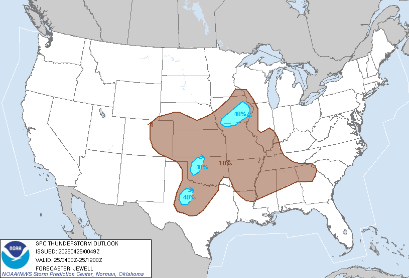
SPC Apr 28, 2014 0100Z Thunderstorm Outlook

http://www.spc.noaa.gov/products/md/

Current Mesoscale Discussions
Updated:  Mon Apr 28 03:19:04 UTC 2014

Valid MD Image
MD Legend Image

http://www.spc.noaa.gov/products/watch/

Current Convective Watches (View What is a Watch? clip)
Updated:  Mon Apr 28 03:18:08 UTC 2014

Valid WW Image WW Graphics Legend

NOAA Weather Radio

http://www.wunderground.com/wxradio/

9:33pm: TORNADO EMERGENCY FOR SWIFTON, ARK

Tornado Warning!!! Memphis, TN Radar

Click for latest Base Reflectivity radar image from the Memphis, TN radar and current weather warnings

Tornado in Vilonia

Permalien de l'image intégrée

Confirmed tornado with this storm moving toward Jackson County. Tune in to KARK 4 news for a LIVE update.

Photo: Confirmed tornado with this storm moving toward Jackson County. Tune in to KARK 4 news for a LIVE update.

tornado Warning!!!Little Rock, AR Radar,tornado on the ground

Click for latest Base Reflectivity radar image from the Little Rock, AR radar and current weather warnings

Tornado Warning!!!north west of Springfield MO

Click for latest Base Reflectivity radar image from the Kansas City/Pleasant Hill, MO radar and current weather warnings

watching, Mark Drees in Ak

Logo        http://tvnweather.com/live

Picture of the Mayflower tornado from a viewer.

Photo: Picture of the Mayflower tornado from a viewer.

http://www.broadcastify.com/listen/feed/5167/?rl=rr

Arkansas SKYWARN in progress. Listen to Amateur Radio storm spotters track tornado on the ground in the northwest area of the Little Rock Metro. Reports are going DIRECTLY to the National Weather Service. (10 minutes ago)

Arkansas Update : Here is a picture from Mayflower, Arkansas Widespread tornado damage being reported. The threat for large damaging tornadoes will continue into the overnight hours

TORNADO EMERGENCY FOR EL PASO AND FLOYD

BULLETIN - EAS ACTIVATION REQUESTED
TORNADO WARNING
NATIONAL WEATHER SERVICE LITTLE ROCK AR
756 PM CDT SUN APR 27 2014

...TORNADO EMERGENCY FOR EL PASO AND FLOYD...

THE NATIONAL WEATHER SERVICE IN LITTLE ROCK HAS ISSUED A

* TORNADO WARNING FOR...
WESTERN WHITE COUNTY IN CENTRAL ARKANSAS...
EAST CENTRAL FAULKNER COUNTY IN CENTRAL ARKANSAS...
EXTREME SOUTHEASTERN CLEBURNE COUNTY IN NORTH CENTRAL ARKANSAS...

* UNTIL 830 PM CDT

* AT 752 PM CDT...STORM SPOTTERS AND NATIONAL WEATHER SERVICE
METEOROLOGISTS WERE TRACKING A CONFIRMED TORNADO WITH REPORTS OF
DAMAGE. THIS TORNADO WAS LOCATED 2 MILES NORTHEAST OF VILONIA...OR
13 MILES NORTH OF LITTLE ROCK AFB. DOPPLER RADAR SHOWED THIS SEVERE
STORM MOVING NORTHEAST AT 50 MPH.

THIS IS A TORNADO EMERGENCY FOR EL PASO AND FLOYD. TAKE COVER NOW.

Large, damaging tornado nearing VILONIA, ARK. Take cover now! (7:46pm)

ORNADO on the ground in Mayflower, AR. Debris picked up by the radar. Estimation at a half mile wide per reports. If you have family in Vilonia call them now! They are in the path.

NOAA Weather Radio

http://www.wunderground.com/wxradio/
http://www.broadcastify.com/listen/ctid/160/web

Tornado on the Ground NOW!!!!BE SAFE

with Brett Adair Watch Live   http://tvnweather.com/live

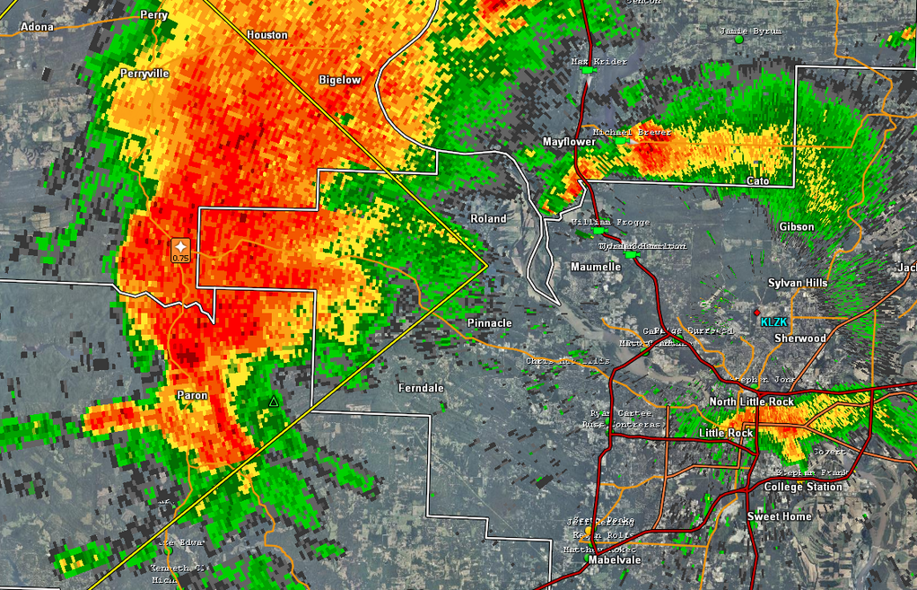
Tornado signature near Maumelle, Arkansas

Little Rock, AR Radar

Click for latest Base Reflectivity radar image from the Little Rock, AR radar and current weather warnings
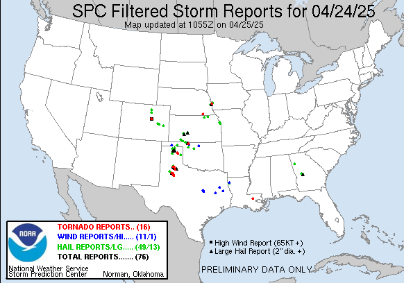
today Filtered Reports Graphic

Rotation increasing with storm west of Little Rock. Moving towards Pinnacle

Click for latest Base Reflectivity radar image from the Springfield, MO radar and current weather warnings

oh ! man alot of problem with maps and everything!!!

http://tvnweather.com/live

and also Dominator 2

Logo