dimanche 31 août 2014
Aug 31, 2014 0600 UTC Day 1 Convective Outlook


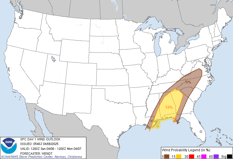
 DAY 1 CONVECTIVE OUTLOOK CORR 1
   NWS STORM PREDICTION CENTER NORMAN OK
   0100 AM CDT SUN AUG 31 2014

   VALID 311200Z - 011200Z

   ...THERE IS A SLGT RISK OF SVR TSTMS FROM THE CENTRAL PLAINS TO THE
   UPPER MS VALLEY...

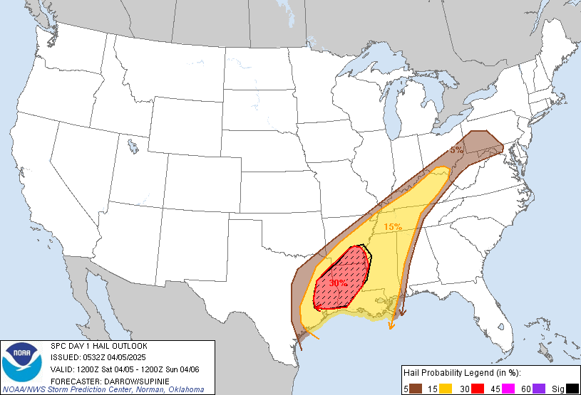
   ...THERE IS A SLGT RISK OF SVR TSTMS FROM PART OF THE MID-ATLANTIC
   STATES TO SRN NEW ENGLAND...

   CORRECTED TO INCLUDE THE EASTERN SLIGHT RISK AREA IN THE SUMMARY.

   ...SUMMARY...
   SEVERE THUNDERSTORMS ARE EXPECTED TO DEVELOP ALONG A COLD FRONT
   SUNDAY AFTERNOON AND EVENING FROM MINNESOTA SOUTHWESTWARD ACROSS
   WESTERN IOWA...AND CENTRAL AND EASTERN NEBRASKA INTO KANSAS.  LARGE
   HAIL...DAMAGING WINDS...AND A FEW TORNADOES ARE EXPECTED WITH THIS
   ACTIVITY.  A FEW SEVERE STORMS WILL ALSO BE POSSIBLE THIS AFTERNOON
   AND EARLY EVENING ACROSS NORTHERN VIRGINIA AND MARYLAND TO SOUTHERN
   NEW ENGLAND.

   ...SYNOPSIS...
   A BROAD NWRN STATES UPPER TROUGH WILL AMPLIFY TODAY ACROSS THE NRN
   AND CENTRAL PLAINS.  A PROGRESSIVE SHORTWAVE TROUGH...CURRENTLY
   MOVING EWD THROUGH THE NRN INTERMOUNTAIN WEST PER WATER VAPOR
   IMAGERY...WILL TRANSLATE THROUGH THE PARENT LARGE-SCALE
   TROUGH...REACHING THE CENTRAL DAKOTAS/NEB BY 01/00Z.  THIS MIDLEVEL
   FEATURE WILL THEN MOVE THROUGH THE MID MO VALLEY...REACHING THE
   UPPER MS VALLEY BY 12Z MONDAY.  A COLD FRONT WILL ADVANCE EWD ACROSS
   THE UPPER MIDWEST...WHILE THE TRAILING PORTION MOVES SEWD ACROSS
   NEB/KS.

   AN EXTENSIVE CORRIDOR OF RICH TROPICAL MOISTURE /PW EXCEEDING 2
   INCHES/ WILL SPREAD THROUGH THE OH VALLEY AND MID ATLANTIC STATES TO
   SRN NEW ENGLAND TODAY.  A SHORTWAVE TROUGH...EMBEDDED WITHIN THIS
   MOISTURE PLUME...WILL TRACK FROM KY/TN TO CENTRAL PA/SRN NY BY LATE
   THIS AFTERNOON/EARLY EVENING...AND THEN UNDERGO SUBSTANTIAL
   WEAKENING AS IT MOVES INTO SRN NEW ENGLAND LATE SUNDAY NIGHT.  WEAK
   HEIGHT FALLS WILL PRECEDE THE KY/TN SHORTWAVE TROUGH ACROSS THE
   CENTRAL APPALACHIANS TO SRN NEW ENGLAND...AS A COMPACT SHORTWAVE
   TROUGH MOVES EWD FROM LOWER MI TOWARD NRN NEW ENGLAND THIS FORECAST
   PERIOD.

   ...UPPER MS VALLEY TO CENTRAL PLAINS...
   EARLY IN THE PERIOD...ELEVATED THUNDERSTORMS WILL LIKELY BE ONGOING
   ALONG THE NOSE OF LLJ ACROSS PORTIONS ERN ND AND NWRN MN.  THIS
   ACTIVITY SHOULD BE ROOTED AT OR ABOVE 850MB WITH THE GREATEST THREAT
   WITH THESE STORMS BEING MARGINALLY SEVERE HAIL BEFORE THEY PROPAGATE
   INTO SRN MANITOBA AND ADJACENT NRN ONTARIO ATTENDANT TO A
   PROGRESSIVE LEAD SHORTWAVE TROUGH AND SURFACE LOW.

   A PLUME OF STEEP MIDLEVEL LAPSE RATES WILL SPREAD E/NEWD FROM THE
   CENTRAL PLAINS TO THE UPPER MS VALLEY.  MEANWHILE...SOUTHERLY
   LOW-LEVEL WINDS AHEAD OF THE COLD FRONT WILL ADVECT MOISTURE NWD
   WITH SURFACE DEW POINTS IN THE MID-UPPER 60S SPREADING INTO ERN
   NEB/IA TO THE UPPER MS VALLEY.  THESE FACTORS COMBINED WITH SURFACE
   HEATING WILL RESULT IN STRONG INSTABILITY /MLCAPE 2000-3000 J PER
   KG/ ACROSS THE CENTRAL PLAINS TO CENTRAL MN.

   TSTMS MAY DEVELOP BY EARLY-MID AFTERNOON ALONG CENTRAL NEB PORTION
   OF THE COLD FRONT.  THIS WILL OCCUR AS FORCING FOR ASCENT ATTENDANT
   TO WEAK HEIGHT FALLS WITH THE LARGE-SCALE TROUGH AND AHEAD OF THE
   PROGRESSIVE NRN INTERMOUNTAIN WEST SHORTWAVE TROUGH REACH THIS AREA.
   EFFECTIVE BULK SHEAR WILL INCREASE ACROSS NEB/NRN KS AS A 50-60 KT
   WLY MIDLEVEL JET EMERGES FROM THE CENTRAL ROCKIES.  STRONGER SURFACE
   HEATING FROM CENTRAL NEB INTO KS RESULTING IN A DEEPLY MIXED
   BOUNDARY LAYER WILL TEND TO RESULT IN DAMAGING WINDS AND LARGE HAIL
   BEING THE PRIMARY THREATS IN THE CENTRAL PLAINS.  GIVEN VERY STEEP
   LAPSE RATES /EXCEEDING 8 C/KM IN THE 700-500-MB LAYER/...STRONG
   INSTABILITY AND EFFECTIVE BULK SHEAR OF 40-50 KT SUGGESTS VERY LARGE
   HAIL WILL BE POSSIBLE.

   MEANWHILE...STORMS ARE EXPECTED TO DEVELOP ALONG THE REST OF THE
   COLD FRONT BETWEEN 21-00Z FROM MN THROUGH ERN SD...ERN NEB...AND WRN
   IA WITH BOTH QUASI-LINEAR AND SUPERCELL STORM STRUCTURES.  ALL
   SEVERE HAZARDS CAN BE EXPECTED.  THE GREATEST SEVERE WEATHER THREAT
   IS EXPECTED ACROSS ERN NEB INTO WRN/CENTRAL IA AND SRN MN FROM LATE
   THIS AFTERNOON INTO THE EARLY EVENING.  THIS REGION WILL HAVE A
   JUXTAPOSITION OF A STRENGTHENING SSWLY LLJ ENHANCING LOW-LEVEL
   SHEAR...LOWER LCLS...AND EFFECTIVE BULK SHEAR VECTORS CROSSING THE
   COLD FRONT SUPPORTING SOME DISCRETE SUPERCELLS AND/OR EMBEDDED
   SUPERCELLS WITHIN THE DEVELOPING LINEAR STRUCTURE.  STORM MERGERS
   INTO THE EVENING SHOULD RESULT IN AN ELONGATED MCS-TYPE COMPLEX
   ADVANCING EWD ACROSS THE UPPER MS TO LOWER MO VALLEYS.

   ...NRN VA/MD/ERN PA/NRN NJ/SERN NY/SRN NEW ENGLAND...
   A CORRIDOR OF MODERATE INSTABILITY /MLCAPE UP TO 1000-1500 J PER KG/
   IS EXPECTED TO DEVELOP THIS AFTERNOON FROM NRN VA/MD TO SRN NEW
   ENGLAND...DESPITE THE PRESENCE OF WEAK MIDLEVEL LAPSE RATES.  THIS
   DESTABILIZATION WILL BE LOCATED ALONG THE ERN PERIPHERY OF EARLY DAY
   CLOUDS/PRECIPITATION EXPECTED TO EXTEND FROM THE OH VALLEY INTO
   CENTRAL PA/NY.  CONVERGENCE IN VICINITY OF A SW-NE ORIENTED
   DIFFERENTIAL HEATING BOUNDARY AND WEAK HEIGHT FALLS SPREADING ACROSS
   THIS REGION SHOULD PROVE SUFFICIENT FOR DEVELOPING TSTMS FROM
   AFTERNOON INTO THE EARLY EVENING.  EFFECTIVE BULK SHEAR OF 30-40 KT
   WILL SUPPORT ORGANIZED STORMS WITH DAMAGING WINDS BEING THE PRIMARY
   THREAT AS ACTIVITY SPREADS FROM WEST TO EAST.
European Storm Forecast Experiment
Storm Forecast
Storm Forecast
Valid: Sun 31 Aug 2014 06:00 to Mon 01 Sep 2014 06:00 UTC
Issued: Sun 31 Aug 2014 07:03
Forecaster: VAN DER VELDE
Valid: Sun 31 Aug 2014 06:00 to Mon 01 Sep 2014 06:00 UTC
Issued: Sun 31 Aug 2014 07:03
Forecaster: VAN DER VELDE
A level 2 was issued for northern Italy, Slovenia and Croatia mainly for excessive convective rainfall, large hail, and isolated tornado chances.
A level 1 was issued for Austria, Czechia and southwestern Poland mainly for large hail.
A level 1 was issued for Turkey mainly for large hail and severe wind gusts.
A level 1 was issued for northern Netherlands and Germany, Denmark and adjacent sea mainly for spout-type tornadoes.
A level 1 was issued for northern parts of Morocco, Algeria and Tunesia mainly for severe wind gusts and large hail.
A level 1 was issued for eastern Belarus mainly for large hail.
SYNOPSIS
An upper level low will move from the North Sea across Germany towards the northern Mediterranean where lee cyclogenesis will occur across N Italy. A strong surface cold front will make its way across Germany towards the Adriatic sea, where it will trigger thunderstorms with a major threat of excessive precipitation during evening and night. A weaker mid level cold front passes Spain from north to south.
Another upper low with associated slight instability resides over Belarus. Another mid level trough slowly passes over western Turkey.
samedi 30 août 2014
| This is tomorrow's forecast for organized severe thunderstorms over the contiguous United States. Please read the description of the risk categories for further information. The latest Day 2 Outlookis available as well as all Outlooks that have been issued today. | Tomorrow's Outlook |
 | |
| This is the day after tomorrow's (day 3) forecast for organized severe thunderstorms over the contiguous United States. Please read the description of the risk categories for further information. The latest Day 3 Outlook is available as well as all Outlooks that have been issued today. | Day 3 Outlook |
 |
Severe Weather Forecast: Sunday Severe Threat, Weekend Flood Threat
http://www.weather.com/news/tornado-central/severe-weather-tracker-page
For Sunday august 31 ,2014

For Sunday august 31 ,2014

Aug 30, 2014 1300 UTC Day 1 Convective Outlook


 DAY 1 CONVECTIVE OUTLOOK
 NWS STORM PREDICTION CENTER NORMAN OK 0750 AM CDT SAT AUG 30 2014 VALID 301300Z - 311200Z ...THERE IS A SLGT RISK OF SVR TSTMS LATE THIS AFTERNOON/EVENING ACROSS THE NRN HIGH PLAINS... ...SUMMARY... A FEW SEVERE STORMS ARE POSSIBLE LATE THIS AFTERNOON AND EVENING ACROSS PARTS OF THE NORTHERN HIGH PLAINS. OTHER STRONG STORMS ARE POSSIBLE TODAY IN A CORRIDOR ARCING FROM THE CENTRAL GULF COAST INTO THE TENNESSEE VALLEY...AND ACROSS LOWER MICHIGAN AND ADJACENT PORTIONS OF THE GREAT LAKES REGION. ...NRN ROCKIES TO NRN HIGH PLAINS THIS AFTERNOON INTO TONIGHT... A MIDLEVEL TROUGH AND ASSOCIATED BELT OF 35-50 KT FLOW WILL PROGRESS EWD OVER THE NRN GREAT BASIN/ROCKIES TO THE NRN HIGH PLAINS BY TONIGHT. AN ACCOMPANYING COLD FRONT WILL MOVE ACROSS WY/MT THIS AFTERNOON/EVENING...AS LEE CYCLOGENESIS IN NE WY DRAWS A NARROW CORRIDOR OF RESIDUAL BOUNDARY LAYER MOISTURE NWWD INTO THE NRN HIGH PLAINS. INITIAL CONVECTION WILL FORM WITHIN THE BAND OF ASCENT PRECEDING THE MIDLEVEL WAVE...AND STORMS SHOULD STRENGTHEN LATE THIS AFTERNOON/EVENING WHILE ENCOUNTERING THE RICHER MOISTURE ON THE HIGH PLAINS E/NE OF THE BIG HORNS. SURFACE HEATING/MIXING NEAR THE LEE CYCLONE AND ALONG THE COLD FRONT WILL REDUCE CONVECTIVE INHIBITION...WHILE MIDLEVEL LAPSE RATES GREATER THAN 7 C/KM AND BOUNDARY LAYER DEWPOINTS IN THE 50S RESULT IN MLCAPE UP TO 1500 J/KG. IN COMBINATION WITH INCREASING VERTICAL SHEAR...THE THERMODYNAMIC PROFILES WILL SUPPORT ORGANIZED CLUSTERS/SUPERCELLS WITH AN ATTENDANT RISK FOR DAMAGING WINDS AND LARGE HAIL BEFORE CONVECTION WEAKENS TONIGHT IN THE CENTRAL DAKOTAS WHERE BUOYANCY WILL BE WEAKER. ...LOWER MI/NRN INDIANA THIS AFTERNOON... A MIDLEVEL TROUGH OVER NW IL/SW WI...AND AN ASSOCIATED SURFACE LOW IN CENTRAL WI...WILL MOVE ENEWD TO NRN LOWER MI BY THIS EVENING. LOW-LEVEL CONVERGENCE/ASCENT WILL BE FOCUSED NEAR THE LOW AND A TRAILING WEAK COLD FRONT AS DAYTIME HEATING REMOVES CONVECTIVE INHIBITION AND 68-70 F DEWPOINTS SPREAD NEWD INTO LOWER MI. SCATTERED THUNDERSTORM DEVELOPMENT IS EXPECTED ALONG THE WIND SHIFT THIS AFTERNOON...WHEN ORGANIZED CLUSTERS/MARGINAL SUPERCELLS COULD PRODUCE ISOLATED DAMAGING GUSTS GIVEN MODERATE BUOYANCY...EFFECTIVE BULK SHEAR NEAR 35 KT...AND A BELT OF 40 KT FLOW IN THE 850-500 MB LAYER FOR POTENTIAL DOWNWARD MOMENTUM TRANSFER IN HEAVY PRECIPITATION CORES. POOR MIDLEVEL LAPSE RATES WILL TEND TO LIMIT UPDRAFT STRENGTH AND ANY HAIL RISK...THOUGH LOWER MI WILL BE MONITORED CLOSELY FOR THE POSSIBILITY OF A LOW-END SLIGHT RISK IN LATER OUTLOOK UPDATES. ...LA AREA TODAY... A PLUME OF TROPICAL MOISTURE /PW VALUES AOA 2.25 INCHES AND LOW-MID 70S DEWPOINTS/ HAS SPREAD INLAND FROM THE NW GULF TO LA IN ASSOCIATION WITH A WEAK MIDLEVEL TROUGH NEAR THE SABINE RIVER. THE MOIST ENVIRONMENT IS SUPPORTING SCATTERED THUNDERSTORMS THIS MORNING...WHILE A BELT OF 30-35 KT SLY FLOW NEAR 850 MB IS CONTRIBUTING TO SOME ENHANCEMENT OF LOW-LEVEL SHEAR /EFFECTIVE SRH OF 150-250 M2 PER S2/. THIS ENVIRONMENT IS SUPPORTIVE OF SOME WEAKLY ROTATING STORMS AND THE RISK FOR A BRIEF TORNADO AND/OR DAMAGING GUST FROM THIS MORNING INTO EARLY AFTERNOON AS THE SYSTEM MOVES NNEWD. ..THOMPSON/MOSIER.. 08/30/2014
European Storm Forecast Experiment
Storm Forecast
Storm Forecast
Valid: Sat 30 Aug 2014 06:00 to Sun 31 Aug 2014 06:00 UTC
Issued: Sat 30 Aug 2014 02:46
Forecaster: TUSCHY
Valid: Sat 30 Aug 2014 06:00 to Sun 31 Aug 2014 06:00 UTC
Issued: Sat 30 Aug 2014 02:46
Forecaster: TUSCHY
A level 1 was issued for S-Norway and the Kattegat mainly for excessive rain and an isolated tornado event.
A level 1 was issued for E-CNTRL Spain mainly for an isolated large hail event.
A level 1 was issued for NW Italy mainly for isolated large hail.
SYNOPSIS
Ex-hurricane's (CRISTOBAL) WAA induces rapid mid-layer thickness increase west of Ireland (e.g. 500 hPa height increase in excess of 10 gpdm/12h). This causes a sharpening thermal gradient over Ireland and UK between the ridge and a stationary vortex over N-Scotland. Both, the northward building ridge and intensifying mid/upper jet winds along the SW fringe of that vortex cause the vortex's slow SE-ward motion during the overnight hours ... approaching Benelux from the NW during the end of the forecast. Advection of moist marine air ahead of that low result in marginal thunderstorm conditions for this forecast period.
Positive tilted trough over NE Europe features cold mid-levels, but no distinct moisture source is available to feed any storms. Hence scarce thunderstorm probabilities exist.
Numerous broad mid/upper waves, cool mid-levels and decreasing mid-layer thickness affects S-Europe including the Mediterranean. As 700 hPa temperatures remain aoa 6°C, the air mass remains capped for most parts ... excluding mountainous regions.
vendredi 29 août 2014
jeudi 28 août 2014
European Storm Forecast Experiment
Storm Forecast
Storm Forecast
Valid: Fri 29 Aug 2014 06:00 to Sat 30 Aug 2014 06:00 UTC
Issued: Thu 28 Aug 2014 20:43
Forecaster: BEYER
Valid: Fri 29 Aug 2014 06:00 to Sat 30 Aug 2014 06:00 UTC
Issued: Thu 28 Aug 2014 20:43
Forecaster: BEYER
A level 1 was issued for Northeastern Spain mainly for large hail and to a lesser extent for severe wind gusts.
A level 1 was issued for Southern France mainly for excessive precipitation.
A level 1 was issued for the coastline of Scotland mainly for tornados.
SYNOPSIS
Two long wave troughs influence the forecast area. One of them is situated over far Eastern Europe / Western Russia bringing rather cool airmasses and unstable conditions to this region. The second trough is influencing Western Europe. Its center is situated over Scotland and moves slowly eastward. A surface low having a perpendicular vertical axis corresponds to it. Its frontal system is influencing Eastern Germany and Poland.
Both troughs are separated by a weak ridge. Its axis is moving from Eastern Germany into Eastern Europe during the forecast time. It is mostly overrun by warm air advection in higher levels and has only weak impact since a frontal system can be found at almost the same place, as described above.
A cut of high that has a loose connection to the ridge, leads to sinking motion and stable conditions over parts of Northern Europe.
Southern Europe is lying south of the frontal zone and is influenced by warm and humid airmasses. A strong capping can be found over most of the Mediterranean. It is somewhat weaker over continental areas.
mercredi 27 août 2014
mardi 26 août 2014
MétéoMédia
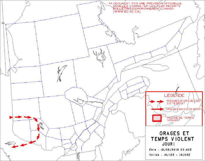
Des alertes de tornades sont en vigueur pour la région du Pontiac. Assurez-vous d'être en sécurité à l'intérieur d'un bâtiment.
Public Weather Alerts for Ontario - south

- Heat Warning
- Severe thunderstorm Warning
- Severe thunderstorm Watch
- http://weather.gc.ca/warnings/index_e.html?prov=son
Public Weather Alerts for Quebec - south

- Severe thunderstorm Warning
- Severe thunderstorm Watch
- http://weather.gc.ca/warnings/index_e.html?prov=sqc
European Storm Forecast Experiment
Storm Forecast
Storm Forecast
Valid: Tue 26 Aug 2014 06:00 to Wed 27 Aug 2014 06:00 UTC
Issued: Mon 25 Aug 2014 21:17
Forecaster: SCHLENCZEK
Valid: Tue 26 Aug 2014 06:00 to Wed 27 Aug 2014 06:00 UTC
Issued: Mon 25 Aug 2014 21:17
Forecaster: SCHLENCZEK
A level 2 was issued for E France and S Germany mainly for tornadoes and severe wind gusts.
A level 1 was issued for NE/E France, Belgium, Luxembourg, S-central Germany and W Czech mainly for severe wind gusts and to a lesser extent for tornadoes.
A level 1 was issued for S UK for a chance of tornadoes.
A level 1 was issued for parts of the North Sea and Baltic Sea for spout-type tornadoes.
SYNOPSIS / DISCUSSION
... SE UK, NE / E France, SW / central Germany ...
A dissipating low pressure system over the British Isles which continues eastwards advects warm and unstable air into W / central Europe. A few hundred J/kg of SBCAPE are forecast consistently in the warm sector by the past runs of GFS and ECMWF, at least partly overlapping with 15 - 25 m/s of 0-6 km bulk shear. T/Td is forecast around 20/16 °C for SW Germany which leads to low LCL heights. Convection should fire up in the late morning / early afternoon hours even though there is some subsidence over the central parts of Germany from the upper ridge. Combined with enhanced LL shear and SRH1, this may allow a few tornadoes. Further north, LL shear is weaker but the background wind field should be intense enough to support isolated severe wind gusts mainly from downward transfer of momentum. Local heavy precipitation is possible but fast storm motion should preclude a risk of flooding in most cases.
Over UK, there is very weak LL shear forecast in the afternoon hours but a weak background flow should support some spout-type tornadoes.
... N Germany, Denmark, N Poland, S Scandinavia and Baltic Sea region...
Sufficient buoyancy and weak background winds enhance the chance for long-lasting convergent flow in the vicinity of convective storms and may lead to funnels which could end up in spout-type tornadoes. The greatest chance for landspouts / waterspouts exists around Denmark and N Poland. Further north, deep layer shear is also quite weak but the stronger background flow will likely disturb the formation of funnels / tornadoes.
Some regions with locally enhanced LL shear exist over Finland but overall instability is likely too low to support a tornado threat covered by a LVL1.
... NW Italy and Mediterranean Sea...
A plume of unstable air is advected from the Balearic Islands towards Italy. It will likely remain strongly capped but in case of convective initiation, isolated storms may profit from 20 - 25 m/s of 0-6 km bulk shear and could develop mesocyclones. Overall threat is likely too marginal for a threat level as the capping inversion is likely too strong for storm development.
lundi 25 août 2014
European Storm Forecast Experiment
Storm Forecast
Storm Forecast
Valid: Mon 25 Aug 2014 06:00 to Tue 26 Aug 2014 06:00 UTC
Issued: Sun 24 Aug 2014 22:01
Forecaster: PISTOTNIK
Valid: Mon 25 Aug 2014 06:00 to Tue 26 Aug 2014 06:00 UTC
Issued: Sun 24 Aug 2014 22:01
Forecaster: PISTOTNIK
A level 1 was issued for some coastlines of Denmark, S Sweden and Poland for waterspouts.
SYNOPSIS and DISCUSSION
Two pronounced cyclones are placed over the British Isles and from Southern Scandinavia into the Baltic region. A strong zonal flow is present to their South, but temporary high pressure and dry, mostly cool air create often hostile conditions for deep convection.
Convection in the Northern half of Europe will mostly take place in well-mixed, weakly sheared polar air in the periphery of the two cyclones. Late in the forecast period, limited area models show well-marked convergence zones between Sweden and Denmark and along the Polish coast which could favor the development of a few waterspouts.
In the greater Mediterranean region, regionally rich moisture is still present but very weak lapse rates allow only limited patches of CAPE. Isolated to scattered showers are expected in the morning over the Adriatic Sea, the Northern Aegean Sea and the Bosporus (including the possibility of one or two waterspouts), and in the afternoon over orographic features of the Southern Balkans. However, forecast instability seems too shallow to produce a lot of lightning or to benefit from 15 to 20 m/s deep-layer shear.
An overlap of more robust CAPE and shear would be present over the Black Sea, but a strong cap will likely suppress convection.
Inscription à :
Commentaires (Atom)






 http://tvnweather.com/live
