 https://www.spc.noaa.gov/products/outlook/archive/2019/pwo.mp4
ZCZNote: Multimedia briefing MP4. Please note the briefing may be out of date 5 hours after its issuance and there will be no subsequent updates during the day. Please send comments or questions to spc.feedback@noaa.gov or via the feedback page.
View What is a Watch? clip.
C SPCPWOSPC ALL
WOUS40 KWNS 130742
ALZ000-ARZ000-LAZ000-MSZ000-TXZ000-131800-
PUBLIC SEVERE WEATHER OUTLOOK
NWS STORM PREDICTION CENTER NORMAN OK
0242 AM CDT SAT APR 13 2019
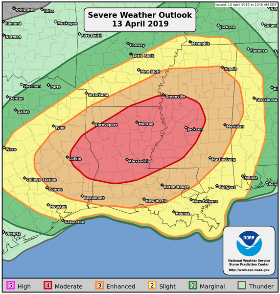
...Severe thunderstorms expected over parts of the East Texas to
lower Mississippi Valley region later today and tonight...
* LOCATIONS...
Central and northern Louisiana
Mississippi
East Texas
Southern Arkansas
Western Alabama
* HAZARDS...
Several tornadoes, a few intense
Widespread damaging winds
Scattered large hail, some baseball size
* SUMMARY...
Numerous severe thunderstorms capable of producing tornadoes,
wind damage and large hail, are expected across parts of east
Texas, Louisiana, southern Arkansas, Mississippi, western
Alabama and surrounding areas today and tonight. The greatest
risk is from east Texas to central Mississippi.
Preparedness actions...
Review your severe weather safety procedures for the possibility
of dangerous weather today. Stay tuned to NOAA Weather Radio,
weather.gov, or other media for watches and warnings. A tornado
watch means that conditions are favorable for tornadoes to form
during the next several hours. If a tornado warning is issued for
your area, move to a place of safety, ideally in a basement or
interior room on the lowest floor of a sturdy building.
&&
..Edwards.. 04/13/2019
Aucun commentaire:
Enregistrer un commentaire