vendredi 30 août 2013

European Storm Forecast Experiment

Storm Forecast
Storm Forecast
Valid: Sat 31 Aug 2013 06:00 to Sun 01 Sep 2013 06:00 UTC
Issued: Fri 30 Aug 2013 14:53
Forecaster: PISTOTNIK
A level 1 and level 2 were issued for Sardegna, Southern Italy, Malta, Tunisia and surroundings for excessive precipitation, large hail, severe wind gusts and tornadoes.

SYNOPSIS

A powerful, autumn-like cyclone near Iceland governs the weather in Northwestern Europe. A secondary low forms in the wake of the Scandinavian mountains and grows deep enough to induce a new cut-off process over Southern Sweden till the end of the forecast period. Its cold front enters Poland, Germany, the Benelux countries and Northern France, while the British Isles get overspread by strong warm air advection again in the second half of the forecast period.
Otherwise, weak gradients with a weak Northwesterly flow and seasonable temperatures prevail over Europe. The remnants of an upper-level low slowly travels eastward across the Mediterranean, with a moderate 500 hPa speed maximum ahead of it from Tunisia towards Greece.


A large 7.0 magnitude earthquake struck early on Friday in waters 57 miles off the remote Alaska island of Adak

Hill City-Remer, MN Tornado August 29, 2013,,,,,by Bob Conzemius

Thumbnail                                                                                 

https://www.youtube.com/watch?v=qaobFQt0RAA

Skopelos 30/8/2013 - Storms

http://www.youtube.com/watch?v=VjotSg9uLGk&feature=youtu.be

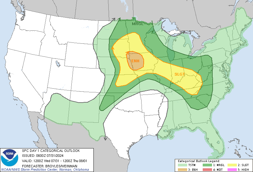
Aug 30, 2013 0600 UTC Day 1 Convective Outlook

DAY 1 CONVECTIVE OUTLOOK  
   NWS STORM PREDICTION CENTER NORMAN OK
   1250 AM CDT FRI AUG 30 2013

   VALID 301200Z - 311200Z

   ...THERE IS A SLGT RISK OF SVR TSTMS OVER A PORTION OF WRN AND CNTRL
   ND...

   ...SYNOPSIS...

   A TYPICAL LATE SUMMER PATTERN WILL PERSIST INTO FRIDAY WITH AN UPPER
   RIDGE CENTERED FROM THE SRN/CNTRL PLAINS INTO THE CNTRL
   ROCKIES...KEEPING THE BELT OF STRONGER WLYS ACROSS THE NRN TIER
   STATES. UPPER TROUGH EMBEDDED WITHIN THIS BELT OF STRONGER FLOW NOW
   MOVING INTO THE PACIFIC NW WILL ADVANCE THROUGH THE SWRN CANADIAN
   PROVINCES. FARTHER EAST...THE SHORTWAVE TROUGH NEAR THE ARROWHEAD OF
   MN WILL CONTINUE ESEWD THROUGH THE GREAT LAKES REGION DURING THE DAY
   AND INTO THE NERN STATES FRIDAY NIGHT. THIS FEATURE WILL FORCE A
   COLD FRONT SWD THROUGH THE GREAT LAKES AREA WITH TRAILING PORTIONS
   LIKELY TO STALL OVER THE CNTRL PLAINS. FARTHER WEST...A LEE TROUGH
   WILL SETUP ACROSS THE NRN HIGH PLAINS WITH A COLD FRONT ADVANCING
   SEWD THROUGH MT IN ASSOCIATION WITH THE UPPER TROUGH MOVING THROUGH
   THE SWRN CANADIAN PROVINCES.  

   ...NRN HIGH PLAINS...

   LOW-LEVEL WINDS WILL SHIFT TO SELY IN POST FRONTAL REGIME WEST OF
   SFC RIDGE MOVING THROUGH ERN CANADA. THIS WILL MAINTAIN UPPER 50S TO
   60F DEWPOINTS OVER THE NRN HIGH PLAINS EAST OF LEE TROUGH BENEATH
   STEEP MID-LEVEL LAPSE RATES. SFC HEATING WILL DESTABILIZE THE
   BOUNDARY LAYER AND CONTRIBUTE TO AXIS OF MODERATE INSTABILITY
   /1500-2000 J/KG MLCAPE/ ACROSS THE WRN DAKOTAS. UPPER RIDGE AXIS
   SHOULD DEAMPLIFY OVER THE NRN PLAINS AS SHORTWAVE TROUGH OVER THE
   PACIFIC NW MOVES THROUGH SWRN CANADA. SYNOPTIC FORCING FOR ASCENT
   WILL REMAIN WEAK OVER THE HIGH PLAINS...AND THERE IS SOME CONCERN
   THAT STORM COVERAGE COULD REMAIN LIMITED. HOWEVER...DEEP MIXING AND
   CONVERGENCE ALONG PRE-FRONTAL/LEE TROUGH MAY BE SUFFICIENT FOR A FEW
   STORMS TO DEVELOP DURING THE AFTERNOON. OTHER STORMS MAY INITIATE
   OVER THE HIGHER TERRAIN OF NRN WY INTO MT AND MOVE INTO THE HIGH
   PLAINS. WIND PROFILES WILL STRENGTHEN ALONG NRN PERIPHERY OF
   DEAMPLIFYING UPPER RIDGE WITH 35-40 KT EFFECTIVE SHEAR SUPPORTIVE OF
   SUPERCELLS. ISOLATED LARGE HAIL WILL BE THE MAIN THREATS THROUGH MID
   EVENING.  

   ...GREAT LAKES AND OH VALLEY AREA...

   SHORTWAVE TROUGH NOW OVER THE UPPER MS VALLEY WILL SHIFT SEWD
   THROUGH THE GREAT LAKES REGION DURING THE DAY ATTENDED BY A SWD
   ADVANCING COLD FRONT. THE MOIST WARM SECTOR WILL DESTABILIZE SOUTH
   OF THIS BOUNDARY WITH MLCAPE FROM 2000-2500 J/KG POSSIBLE.
   HOWEVER...THE DEEPER FORCING AND BELT OF STRONGER FLOW ALOFT
   ATTENDING THE SHORTWAVE TROUGH WILL TEND TO REMAIN NORTH AND SHIFT
   EAST OF WHERE STRONGER DESTABILIZATION IS OCCURRING.
   NEVERTHELESS...A FEW STORMS WILL LIKELY REDEVELOP ALONG THE SWD
   ADVANCING COLD FRONT DURING THE AFTERNOON. WIND PROFILES WITH
   VERTICAL SHEAR FROM 25-35 KT SHOULD GENERALLY PROMOTE
   MULTICELLS...BUT THE THERMODYNAMIC ENVIRONMENT MAY SUPPORT SOME
   THREAT FOR ISOLATED STRONG TO DAMAGING WIND GUSTS AND HAIL. WILL
   MAINTAIN 5% SEVERE PROBABILITIES THIS OUTLOOK...BUT A CATEGORICAL
   RISK MAY BE NEEDED IN LATER UPDATES.

European Storm Forecast Experiment

Storm Forecast
Storm Forecast
Valid: Fri 30 Aug 2013 06:00 to Sat 31 Aug 2013 06:00 UTC
Issued: Thu 29 Aug 2013 20:44
Forecaster: TUSCHY
A level 2 was issued for NE Algeria, N-Tunisia, Sardinia, the Tyrrhenian Sea and Sicily mainly for large to very large hail (hail diameter in excess of 5 cm is possible), severe wind gusts and excessive rain. An isolated tornado event is possible.

A level 1 surrounds the level 2 with similar risks but a lesser probability for extreme events.

A level 1 was issued for SE Spain mainly for an isolated large hail and excessive rain event.

SYNOPSIS

Multiple upper troughs affect the European weather. A broad trough enters the Ukraine from the west with a slow motion to the east. Another trough is situated over the W-Mediterranean with an autumn-like deep depression approaching Scotland from the NW.

Numerous progressive fronts enter the forecast area from the NW, affecting areas from Irland to W-Norway. Further south over the Mediterranean, an E-W aligned quasi-stationary front plays a role for DMC activity.

mardi 27 août 2013

VOLCANO VENT OPENS NEAR ROME AIRPORT AUGUST 27,

Thumbnailhttps://www.youtube.com/watch?v=bo14F2JxmVA

Waterspout! Photo: Barbara Currier,Slovenia (45.53 N, 13.50 E) 26-08-2013

551049_584458798284641_1801161408_n

Waterspout,Umag Istarska Croatia (45.43 N, 13.52 E) 26-08-2013

Tornado, Szolnok near Szolnok town Jász-Nagykun-Szolnok Hungary (47.13 N, 20.05 E) (+/- 10 km) 26-08-2013

Two waterspouts have joined the sea at Anzio (RM) Anzio over Mar Tirreno, near Anzio Lazio Italy (41.44 N, 12.57 E) 27-08-2013

http://www.youreporter.it/video_Due_trombe_marine_si_sono_unite_sul_mare_di_anzio_RM                     Two waterspouts have joined the sea at Anzio (RM)

European Storm Forecast Experiment

Storm Forecast
Valid: Wed 28 Aug 2013 06:00 to Thu 29 Aug 2013 06:00 UTC
Issued: Tue 27 Aug 2013 23:07
Forecaster: PUCIK
A level 2 was issued for SE Spain mainly for large hail, severe wind gusts and excessive precipitation.

A level 1 was issued for southern part of Spain mainly for large hail, severe wind gusts and excessive precipitation.

A level 1 was issued for Morocco and W Algeria mainly for (very)large hail and damaging wind gusts.

A level 2 was issued for Algeria and Tunisia mainly for (very) large hail and damaging wind gusts.

A level 2 was issued for E Serbia, S Romania and N Bulgaria mainly for large hail, excessive precipitation and to the lesser degree for severe wind gusts and tornadoes.

A level 1 was issued for Slovenia, Croatia, SW Hungary and NW Romania mainly for isolated excessive precipitation event.

A level 1 was issued for southern Balkans mainly for large hail and severe wind gusts.

SYNOPSIS

An active weather pattern will continue over Southern Europe as large scale cyclonic vortex persists over Central Europe, shifting eastwards with several short-wave troughs rotating around its periphery. The first one will affect Iberia during the day, the second one will cross from Italy towards the Balkans and the latter one will translate towards the Baltic states. Enhanced mid and upper tropospheric flow is simulated at the southern flank of the vortex. Another significant trough is expected to affect Scandinavia during the forecast period, while two ridges are forecast over the Atlantic and over Russia. As such, general synoptic scale situation slightly resembles an "Omega" pattern albeit it is not very stable with weakening vortex. Main frontal zone will lie over the Mediterranean and Balkans with weak temperature gradients over the rest of Europe, perhaps apart from Scandinavia.

Special Weather Statements for Ontario,

Today..Isolated thunderstorms are likely across Southern Ontario. 
There is a slight risk that some of these thunderstorms may be
Severe over the southwest due to torrential downpours, large hail
And damaging winds this afternoon. Isolated thunderstorms are 
possible over Northern Ontario.  Some of these thunderstorms may  
approach severe limits due to wind and hail.http://weather.gc.ca/warnings/SWS_bulletins_e.html?prov=on

Aug 27, 2013 0600 UTC Day 1 Convective Outlook

DAY 1 CONVECTIVE OUTLOOK  
   NWS STORM PREDICTION CENTER NORMAN OK
   1255 AM CDT TUE AUG 27 2013

   VALID 271200Z - 281200Z

   ...THERE IS A SLGT RISK OF SVR TSTMS ACROSS PARTS OF THE UPPER GREAT
   LAKES TO THE MID-UPPER OH VALLEY...

   ...GREAT LAKES TO THE MID-UPPER OH VALLEY REGION...
   A BAROCLINIC ZONE ORIENTED NW-SE FROM NRN-ERN WI...THROUGH SRN LOWER
   MI TO CENTRAL/ERN OH SHOULD REMAIN QUASI-STATIONARY THIS FORECAST
   PERIOD WITHIN THE NERN PERIPHERY OF A LARGE UPPER HIGH PRESSURE AREA
   CENTERED OVER ERN KS/MO.  DESPITE RELATIVELY WEAK MIDLEVEL LAPSE
   RATES /AOB 6.5 C PER KM/...A MOIST AIR MASS /PW 1.5 TO 2 INCH/ INVOF
   THE SURFACE FRONT AND DIABATIC HEATING WILL RESULT IN MODERATE
   INSTABILITY /MLCAPE 1500-2500 J PER KG/ EXTENDING FROM THE UPPER MS
   VALLEY TO THE OH VALLEY AND CENTRAL APPALACHIANS. 

   A CLUSTER OF TSTMS/MCS SHOULD BE ONGOING AT 12Z TODAY ACROSS PARTS
   OF ERN WI INTO CENTRAL AND SRN LOWER MI. AN APPARENT MCV AND/OR
   MIDLEVEL IMPULSE ASSOCIATED WITH THIS EARLY MORNING TSTM ACTIVITY IS
   EXPECTED TO TRACK SEWD INTO SRN LOWER MI AND THE MID-UPPER OH VALLEY
   FROM LATE THIS MORNING THROUGH THE AFTERNOON.  FORECAST
   DESTABILIZATION DOWNSTREAM OF THIS MIDLEVEL SYSTEM SHOULD CONTRIBUTE
   TO NEW TSTM DEVELOPMENT AND/OR RE-INTENSIFICATION ALONG THE LEADING
   EDGE OF THE EARLY MORNING CLUSTER.  STRENGTHENING EFFECTIVE BULK
   SHEAR PER 30-40 KT NWLY MIDLEVEL WINDS SPREADING ACROSS SRN LOWER MI
   INTO OH/WRN PA WILL SUPPORT STORM ORGANIZATION WITH THE POTENTIAL
   FOR MULTICELLS...A FEW SUPERCELLS...AND LINES/BOWS. HAIL AND
   DAMAGING WINDS WILL BE THE PRIMARY THREATS ACROSS THE SRN EXTENT OF
   THE SLIGHT RISK AREA.

   MEANWHILE...ACROSS THE NRN EXTENT OF THE SLIGHT RISK AREA...SURFACE
   HEATING INTO THE AFTERNOON IN THE WAKE OF ANY REMAINING CLOUDINESS
   OVER NRN-ERN WI THIS MORNING WILL SUPPORT DESTABILIZATION/MODERATE
   INSTABILITY.  MODELS SUGGEST ANOTHER MIDLEVEL IMPULSE...EXPECTED TO
   BE TOPPING THE RIDGE OVER ND/NRN MN AT 12Z...WILL TURN SEWD TODAY
   REACHING NRN/ERN WI BY MID-LATE AFTERNOON.  FORCING FOR ASCENT WITH
   THIS FEATURE AND LOW LEVEL WAA IN THE NOSE OF A RE-STRENGTHENING
   SWLY LLJ INTO WI SHOULD SUPPORT NEW TSTM DEVELOPMENT INVOF THE
   SURFACE FRONT IN NRN/ERN WI BY 21-00Z.  EFFECTIVE BULK SHEAR OF
   40-50 KT ORIENTED PARALLEL TO THE BAROCLINIC ZONE WILL SUPPORT
   SUPERCELLS WITH BOWING SEGMENTS POSSIBLE.  DAMAGING WINDS AND HAIL
   WILL BE THE PRIMARY THREATS.  WAA WITHIN THE NOSE OF A VEERING LLJ
   THIS EVENING/TONIGHT ACROSS SRN WI TO LOWER MI AND NRN IND/OH AND
   ASCENT WITH THE MIDLEVEL IMPULSE SHOULD FAVOR UPSCALE GROWTH INTO AN
   MCS ADVANCING SEWD...POTENTIALLY REACHING NRN/CENTRAL OH BY 12Z
   WEDNESDAY.  DESPITE BOUNDARY LAYER STABILIZATION IN ADVANCE OF THIS
   MCS...A W/NWLY INFLOW OF MODERATE ELEVATED INSTABILITY AFTER 28/00Z
   SHOULD MAINTAIN THIS ACTIVITY SEWD WITH SOME REMAINING SEVERE
   WEATHER THREAT.

lundi 26 août 2013

GIANT TIDAL WAVE SWEEPS AWAY SPECTATORS IN CHINA Aug 23 2013

https://www.youtube.com/watch?v=ufl7cHu4ElQ
Thumbnail

Extreme Devil Wedge

Large dust devil - Perris, CA - 8/25/2013 https://www.youtube.com/watch?v=b6GO5ic7ZE4
Thumbnail

Waterspout Genova over Largo di Genova [bay] Liguria Italy,25-08-2013

Waterspout Umag Istarska Croatia (45.43 N, 13.52 E) 26-08-2013

Tropical Storm Kong-rey

European Storm Forecast Experiment

Storm Forecast
Storm Forecast
Valid: Tue 27 Aug 2013 06:00 to Wed 28 Aug 2013 06:00 UTC
Issued: Mon 26 Aug 2013 17:15
Forecaster: PISTOTNIK
A level 2 was issued for N Algeria and N Tunisia, and a level 1 for much of the W and Central Mediterranean, Italy and the W Balkans for large hail, severe wind gusts, excessive precipitation and tornadoes.

A level 1 was issued for the Alpine region mainly for excessive precipitation.

SYNOPSIS

An extensive upper-level low with several shallow centers stretches from Belarus and the Ukraine across Central Europe into France. The subtropical jet stream curves around its Southern flank, where strong vertical wind shear and cooling upper levels on top of the very warm sea set the stage for an active severe weather day over much of the Mediterranean region. The main foci for convective initiation are a long and diffuse frontal boundary across the Balkans and the Mediterranean and a series of passing vorticity maxima in its wake.
Further North, a large anticyclone slowly moves from Southern Scandinavia into Western Russia, connected by a bridge to a second high over the Atlantic Ocean. The polar jet and the main frontal zone are displaced to Northern Scandinavia, which gets crossed by a cold front and a progressive trough late in the forecast period.

dimanche 25 août 2013

Severe Thunderstom Warning for Sudbury and area

damaging winds and heavy rainfall..Lots of lightning

Britt Radar

Public Weather Alerts for Ontario - north

Map of Ontario - northhttp://weather.gc.ca/warnings/index_e.html?prov=non

Severe thunderstom warning for Sault Ste-Marie and region

Hail up to 3/4 inch,rotating thunderstorm ,flash flood,this is a Warning from Meteo Active Weather

Santa Severa Lazio Italy (42.03 N, 11.95 E) 25-08-2013 (Sunday)

Tornado in Santa Severa: Damage on the waterfront

Boats on the street and in the houses, street lamps and sunbeds flew over the roofs collapsed. The damage caused by the tornado that hit the coast of Santa Severa
(Frederick Bitti)
Video.repubblica.it/edizione/roma/tromba-d-aria-a-santa-severa-i-danni-sul-lungomare/138199/136745

Hurricanes & Tropical Cyclones

Aug 25, 2013 1300 UTC Day 1 Convective Outlook

DAY 1 CONVECTIVE OUTLOOK  
   NWS STORM PREDICTION CENTER NORMAN OK
   0742 AM CDT SUN AUG 25 2013

   VALID 251300Z - 261200Z

   ...THERE IS A SLGT RISK OF SVR TSTMS ACROSS PARTS OF THE UPPER MS
   VALLEY INTO UPPER GREAT LAKES...

   ...SYNOPSIS...

   AN EXPANSIVE MID TO UPPER-LEVEL ANTICYCLONE WILL REMAIN ANCHORED
   OVER ERN KS/WRN MO WITH A NUMBER OF LOW-AMPLITUDE VORTICITY MAXIMA
   PIVOTING AROUND ITS PERIPHERY.  TO THE WEST...A PRONOUNCED VORTICITY
   MAXIMUM WITHIN THE BASE OF A LARGER-SCALE TROUGH OVER THE FAR NERN
   PACIFIC WILL PROGRESS NNEWD FROM THE NRN CA COAST ACROSS THE PACIFIC
   NW.  IN THE LOW LEVELS...A WEAK COLD FRONT ASSOCIATED WITH A
   MIDLEVEL IMPULSE CROSSING ONTARIO INTO QUEBEC WILL SETTLE SWD INTO
   THE UPPER GREAT LAKES.  THE WRN EXTENSION OF THIS BOUNDARY WILL
   REMAIN QUASI-STATIONARY FROM LOW PRESSURE OVER SD TO A DEVELOPING
   LEE CYCLONE OVER CNTRL MT.

European Storm Forecast Experiment

Storm Forecast
Storm Forecast
Valid: Sun 25 Aug 2013 06:00 to Mon 26 Aug 2013 06:00 UTC
Issued: Sun 25 Aug 2013 05:27
Forecaster: VAN DER VELDE
A level 2 was issued for Italy and northwestern Balkan mainly for severe convective wind gusts and large hail.

A level 1 was issued for Italy and northwestern Balkan mainly for severe convective wind gusts, large hail and tornadoes.

A level 1 was issued for eastern Spain mainly for large hail.

A level 1 was issued for northern Morocco, Algeria and Tunesia mainly for severe convective wind gusts and large hail.

SYNOPSIS

A multicore low pressure system is situated over France, Germany and northern Italy. Cool airmass has entered France and the northwestern Mediterranean. Warm unstable airmass is sticking around Italy and the western Balkan, as well as in a small pocket over eastern Spain. An occluded front with weak conditional instability stretches from the Alps to the Netherlands. From Czechia to Moldova it has the form of a warm front. A merry-go-round of shortwave upper troughs affect Netherlands, western France, northern Italy and Hungary.
An occlusion of another low with a zone of unstable air is present over western Russia. Northern Africa is also active and very high-based.
Model buoyancy profiles look weak in the mixed phase region over France, Germany, Romania and Russia, with reduced potential for significant electrification and hail production.

samedi 24 août 2013

Public Weather Alerts for Manitoba

Map of Manitobawarning or watch                                       http://weather.gc.ca/warnings/index_e.html?prov=mb

Public Weather Alerts for Ontario - north

Map of Ontario - northwarning or watch                 http://weather.gc.ca/warnings/index_e.html?prov=non

European Storm Forecast Experiment

Storm Forecast
Storm Forecast
Valid: Sat 24 Aug 2013 06:00 to Sun 25 Aug 2013 06:00 UTC
Issued: Fri 23 Aug 2013 15:46
Forecaster: PISTOTNIK
A level 1 area was issued for parts of W Russia mainly for excessive precipitation.

Level 1 areas were issued for E Spain, parts of France, Switzerland and N Italy for excessive precipitation, severe wind gusts and large hail.

SYNOPSIS

A high pressure system temporarily establishes over Scandinavia, flanked by an upper-level low over Belarus and a second upper-level low that cuts off over Northern France Saturday night. This results in a transient omega-like pattern. Cool air digs southward along the Western flanks of these lows over the Baltic States, Poland and over the British Isles and France, respectively, separated by a thinning warm sector over Central Europe.
The Mediterranean region sees a mostly quiescent day in-between, but the nose of a jet streak that extends from Ireland via Southern France towards the Ligurian Sea already promotes a beginning Genoa cyclogenesis and presages more turbulent days again.

vendredi 16 août 2013

Time- lapse , dust devil 16 Agosto 2013 , visto da Misterbianco ( CT )

https://www.youtube.com/watch?v=qDHFq5ZyUPg

TORNADO in Sicilia AGIRA Autostrada A19 14/08/2013

Thumbnailhttps://www.youtube.com/watch?v=2aFyzt4VgDA

Tornado Catenanuova near A19 Highway, W of Catenanuova, S of Agira Sicilia Italy (37.56 N, 14.57 E) (+/- 1 km) 14-08-2013

he tornado yesterday afternoon in central Sicily: impressive photos from the highway A19 Palermo-Catania                                                     http://www.meteoweb.eu/2013/08/il-tornado-di-ieri-pomeriggio-nella-sicilia-centrale-foto-impressionanti-dallautostrada-a19-palermo-catania/220695/

Tornado (EF!)Kukkovka S of Petrozavodsk Kareliya Russian Federation (61.73 N, 34.35 E) 14-08-2013

Daily News → In the Old Kukkovka swept tornado damaged five houses (PHOTOS)   http://gubdaily.ru/blog/news/po-staroj-kukkovke-pronessya-smerch-povrezhdeno-pyat-domov-foto/

waterspout,Rimini over Adriatic Sea, several KMs NE / E of Rimini Emilia-Romagna Italy

http://www.youtube.com/watch?v=HfiXQE_Uf8M

Waterspout.(Kattegat) over Kattegat. Waterspout 30 km off coast at 57.16 N 11.64 E, 18:45 UTC - 19:05 UTC. Hallands Län Sweden

waterspout ,Slangentangen E of Slangentangen Vestfold Norway (59.33 N, 10.51 E) (+/- 1 km) 13-08-2013

http://tb.no/nyheter/trodde-nesten-ikke-vare-egne-oyne-1.8017172

Waterspout ,Falkenberg over Kattegat Hallands Län Sweden (56.80 N, 12.43 E) (+/- 3 km) 13-08-2013

http://hn.se/nyheter/falkenberg/1.2290728-tromb-utanfor-falkenberg

Tornado Raiskums Pārgaujas novads Latvia (57.30 N, 25.15 E) 13-08-2013

Tuesday afternoon Raiskumā raging whirlwinds, causing more severe damage, according to local government.

waterspout,Wicie Zachodniopomorskie Poland (54.50 N, 16.47 E) 13-08-2013

http://kontakt24.tvn24.pl/artykul,traba-powietrzna-w-jaroslawcu-woj-zachodniopomorskie,1545708.html

Waterspout Liseleje over Hesselø Bugt, NW of Liseleje Sjælland Denmark (56.04 N, 11.93 E) (+/- 3 km) 12-08-2013

Tropical Weather & Hurricanes

Global Sea-Surface Temperature

Aug 16, 2013 0600 UTC Day 1 Convective Outlook

DAY 1 CONVECTIVE OUTLOOK  
   NWS STORM PREDICTION CENTER NORMAN OK
   1235 AM CDT FRI AUG 16 2013

   VALID 161200Z - 171200Z

   ...NO SVR TSTM AREAS FORECAST...

   ...SOUTHEAST...

   MEAN LONG WAVE TROUGH IS EXPECTED TO HOLD ACROSS THE MS VALLEY AS A
   SECONDARY SHORT-WAVE TROUGH DIGS INTO THE BACK SIDE OF THIS FEATURE
   OVER AR/LA.  NET RESULT WILL BE FOR MOIST SWLY FLOW REGIME TO
   CONTINUE ACROSS THE SERN U.S. WHERE PW VALUES REMAIN ON THE ORDER OF
   2 INCHES.  WHILE POOR LAPSE RATES ARE EXPECTED ACROSS THIS REGION
   THERE IS REASON TO BELIEVE A FEW ROBUST THUNDERSTORMS COULD EMERGE
   DURING THE DAY WITHIN BROADER CORRIDOR OF CONVECTION FROM THE NERN
   GOM ACROSS NRN FL/SRN GA.  SIMILAR TO THE LAST FEW DAYS DIURNAL
   HEATING COULD STRENGTHEN STORMS ENOUGH FOR A FEW WET MICRO BURSTS.

   ...SOUTHERN HIGH PLAINS...

   DEEP LAYER FLOW IS EXPECTED TO GRADUALLY VEER AND BECOME DUE NLY BY
   EARLY EVENING ACROSS THE HIGH PLAINS AS LONG WAVE TROUGH REMAINS
   ESTABLISHED OVER THE MS VALLEY.  WITH SFC RIDGING EXPECTED ACROSS
   THE MID MS VALLEY/ERN PLAINS IT APPEARS FAIRLY DEEP ELY BOUNDARY
   LAYER COMPONENT WILL FORCE MOISTURE/CONVERGENCE TOWARD THE EAST
   SLOPES OF THE ROCKIES.  GREATEST CONCENTRATION OF TSTMS IS EXPECTED
   TO GRADUALLY SHIFT INTO PORTIONS OF THE SWRN U.S./SRN ROCKIES AND
   WEST TX WHERE INSTABILITY/MOISTURE WILL CONGREGATE.

   ONGOING MCS OVER NRN OK MAY SPREAD/PROPAGATE SSWWD TOWARD NWRN TX BY
   SUNRISE FRIDAY.  WHILE THIS ACTIVITY MAY PRODUCE GUSTY
   WINDS/MARGINALLY SEVERE HAIL IT APPEARS RENEWED CONVECTION WILL
   DEVELOP ALONG EDGE OF CLOUD DEBRIS/OUTFLOW ACROSS THE TX SOUTH
   PLAINS INTO THE EDWARDS PLATEAU.  A FEW ROBUST UPDRAFTS COULD
   GENERATE HAIL OR PERHAPS SOME GUSTY WINDS AS DEEP LAYER SHEAR WILL
   PROVE SUPPORTIVE OF AT LEAST ORGANIZED MULTI-CELL STORMS.

   ...INTERIOR OREGON...

   MODEST SWLY FLOW ALOFT WILL PERSIST ACROSS THE NWRN U.S. THROUGH THE
   UPCOMING DAY1 PERIOD.  WHILE WEAK HEIGHT RISES ARE EXPECTED ACROSS
   ORE FRIDAY IT APPEARS STRONG HEATING WILL CONTRIBUTE TO ISOLATED
   THUNDERSTORMS BY LATE AFTERNOON.  FORECAST SOUNDINGS SUGGEST
   STRONGLY SHEARED HIGH BASED STORMS COULD PRODUCE GUSTY WINDS AND
   MARGINALLY SEVERE HAIL.  FORECAST MOISTURE APPEARS A BIT TOO
   MARGINAL TO WARRANT ORGANIZED SEVERE ACROSS THIS REGION.