lundi 4 mars 2019

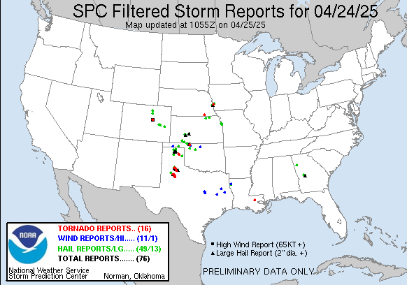
dimanche 3 mars 2019

Mesoscale Discussion 0142
   NWS Storm Prediction Center Norman OK
   1035 AM CST Sun Mar 03 2019

   Areas affected...south-central and southeast LA

   Concerning...Severe potential...Watch likely

   Valid 031635Z - 031700Z

   Probability of Watch Issuance...80 percent

   SUMMARY...The severe risk is increasing over south-central and
   southeast LA.  A tornado watch may be needed soon for parts of
   southeast LA (near and north of Lake Pontchartrain).

   DISCUSSION...The 9am CST raob from Breaux Bridge, LA (Vortex2SE
   special raob) showed little remaining convective inhibition and a
   profile exhibiting 1100 J/kg MLCAPE.  Low-level shear is adequate
   but a tendency for veering low-level flow with time as the surface
   cyclone develops east across central AL will tend to limit hodograph
   size with time.  Nonetheless, a severe risk mainly in the form of
   strong to locally severe gusts and perhaps a tornado may accompany
   the more intense storms late this morning through the afternoon.

   ..Smith/Hart.. 03/03/2019

Mesoscale Discussion 141

Mesoscale Discussion 0141
   NWS Storm Prediction Center Norman OK
   0959 AM CST Sun Mar 03 2019

   Areas affected...southern and central AL...western FL
   Panhandle...southwest and west-central GA

   Concerning...Severe potential...Tornado Watch likely

   Valid 031559Z - 031800Z

   Probability of Watch Issuance...95 percent

   SUMMARY...The initial signs of discrete convective development are
   occurring late this morning in the warm sector.  Rapid environmental
   changes are forecast to occur between 10am CST/11am EST and the mid
   afternoon.

   DISCUSSION...Visible satellite imagery shows widespread cloud cover
   across the destabilizing warm sector to the south of the primary
   frontal zone where the surface low is forecast to develop eastward
   across central AL into north-central GA later today.  Surface
   dewpoints over the FL Panhandle and far southern AL have risen
   around 3 degrees F in the past hour and are indicative of strong
   poleward moisture advection occurring as the surface cyclone
   develops.  The warming/moistening are contributing to MLCAPE
   increasing from near 0 J/kg to upwards of 1000-1500 J/kg by
   early-mid afternoon.

   Late morning VAD data show around 35-45 kt southwesterly 700mb flow
   from KMOB/KBMX/KMXX/KEOX in central and southern AL but stronger
   flow (50-55 kt) is now being observed farther west in Jackson, MS
   (KDGX) and Slidell, LA (KLIX).  Models show the flow intensifying
   further over AL and GA this afternoon (55-60 kt 700mb).  The end
   result is a hodograph exhibiting little weakness (no veer-back-veer
   tendency or a weak layer of winds).  In summary, as moderate
   buoyancy and strong/veering flow through the profile combine with
   moist low levels, the threat for strong low-level mesocyclones
   associated with the discrete storms will increase, along with a
   corresponding risk for tornadoes of which a few may be strong.
Southern Mississippi Valley Sector

 Areas affected...southern MS into southwest AL

   Concerning...Severe potential...Watch possible

   Valid 031513Z - 031615Z

   Probability of Watch Issuance...40 percent

   SUMMARY...A locally damaging wind threat may develop this morning.
   Convective trends will be monitored in the short term as to whether
   a tornado watch will be needed prior to an expected tornado watch
   issuance time by the 11am-12pm period.

   DISCUSSION...Radar imagery shows an intensifying band of
   thunderstorms over southern MS from near the surface low
   southwestward along the cold front.  The developing band of storms
   is expected to move eastward near the primary frontal zone extending
   eastward from the surface low across south-central AL.  The maritime
   warm front near the I-10 corridor is becoming more diffuse with time
   but the airmass along and south of the front is where appreciable
   surface-based buoyancy resides.  As such, only weak instability is
   located currently over east-central MS to the east of Jackson.
   Nonetheless, as additional boundary layer warming/moistening occurs,
   the combination of a destabilizing boundary layer and the fast
   eastward motion of the squall line (40-45 kt) may facilitate an
   increased risk for horizontal momentum transport in the form of
   strong to locally severe gusts in the next 1-2 hours.  If this
   appears imminent, a tornado watch may be needed sooner than a
   currently anticipated tornado watch issuance time by 11am-12pm CST.

Inscription à :
Articles (Atom)