lundi 30 juin 2014
European Storm Forecast Experiment
Storm Forecast
Storm Forecast
Valid: Tue 01 Jul 2014 06:00 to Wed 02 Jul 2014 06:00 UTC
Issued: Mon 30 Jun 2014 22:06
Forecaster: BEYER/GATZEN
Valid: Tue 01 Jul 2014 06:00 to Wed 02 Jul 2014 06:00 UTC
Issued: Mon 30 Jun 2014 22:06
Forecaster: BEYER/GATZEN
A level 2 was issued for north-eastern Spain and South-western France mainly due to large hail and severe wind gusts.
A level 2 was issued for north-western parts of Russia mainly due to large hail and severe wind gusts as well as for tornadoes.
A level 1 was issued for central Ukraine mainly due to severe wind gusts and large hail.
A level 1 was issued for the northern and eastern Alps mainly for large hail.
SYNOPSIS
A broad trough is covering most parts of Europe. One branch of the trough is influencing Eastern Europe. Its axis is orientated from the Baltic States all the way to the western parts of the Black Sea. With a westerly component rather cool air masses are advected into Central, and Eastern as well as Northern Europe. Downstream of the trough axis, hot and humid air masses are advected with a southerly flow into the easternmost parts of Europe as well as Western Russia.
The second branch of the broad trough is influencing Western Europe. During the forecast period the southern part of the positively tilted trough cuts of near the Bay of Biscay. On the downstream axis of the cut of low warm and humid air masses are advected to the north, influencing most parts of Southern Europe (Eastern Spain, Southern France, Italy and the Balkan Peninsula). On the other hand, over Portugal, Western Spain and the British Isles rather cool air masses are active. Both air masses are separated by a quasi-stationary surface cold front.
The ridge between both branches of the broad trough is quite shallow showing only slight anticylonical curvature.
TORNADO WARNING FOR.
THE NATIONAL WEATHER SERVICE IN PLEASANT HILL HAS ISSUED A

* TORNADO WARNING FOR...
  NORTHEASTERN DAVIESS COUNTY IN NORTH CENTRAL MISSOURI...
  GRUNDY COUNTY IN NORTH CENTRAL MISSOURI...
  SOUTHWESTERN SULLIVAN COUNTY IN NORTH CENTRAL MISSOURI...

* UNTIL 845 PM CDT
Tornado warning in Timmins - Cochrane - Iroquois Falls
- Timmins - Cochrane - Iroquois Falls
Updated or ended by 7:49 p.m. EDT.
At 7:00 PM EDT, a thunderstorm near the Quebec border that has a history of showing signs of rotation based on radar. A tornado is possible from this thunderstorm. This thunderstorm will cross into Quebec at around 7:30 PM.
At 7:00 PM EDT, a thunderstorm near the Quebec border that has a history of showing signs of rotation based on radar. A tornado is possible from this thunderstorm. This thunderstorm will cross into Quebec at around 7:30 PM.
This is a dangerous and potentially life-threatening situation. Take cover immediately, if threatening weather approaches.
Go indoors to a room on the lowest floor, away from outside walls and windows, such as a basement, bathroom, stairwell or interior closet. Leave mobile homes, vehicles, tents, trailers and other temporary or free-standing shelter, and move to a strong building if you can. As a last resort, lie in a low spot and protect your head from flying debris.
In Canada, lightning kills up to 10 people every year.
Remember, when thunder roars, go indoors.
Emergency Management Ontario recommends that you take cover immediately, if threatening weather approaches.
Environment Canada meteorologists will update alerts as required, so stay tuned to your local media or Weatheradio. Email reports of severe weather to storm.ontario@ec.gc.ca or tweet with the hashtag #ONStorm.
A TORNADO WARNING REMAINS IN EFFECT FOR WESTERN MERCER AND EAST
CENTRAL HARRISON COUNTIES UNTIL 615 PM CDT...

AT 558 PM CDT...A SEVERE THUNDERSTORM CAPABLE OF PRODUCING A TORNADO
WAS LOCATED NEAR RIDGEWAY...AND MOVING EAST AT 40 MPH.

HAZARD...TORNADO AND PING PONG BALL SIZE HAIL.

SOURCE...RADAR INDICATED ROTATION.
http://www.spc.noaa.gov/products/watch/
| Current Convective Watches (View What is a Watch? clip) Updated: Mon Jun 30 23:12:08 UTC 2014   |
http://www.spc.noaa.gov/products/md/
Current Mesoscale Discussions
Updated: Mon Jun 30 23:09:03 UTC 2014


Updated: Mon Jun 30 23:09:03 UTC 2014


Jun 30, 2014 0600 UTC Day 1 Convective Outlook
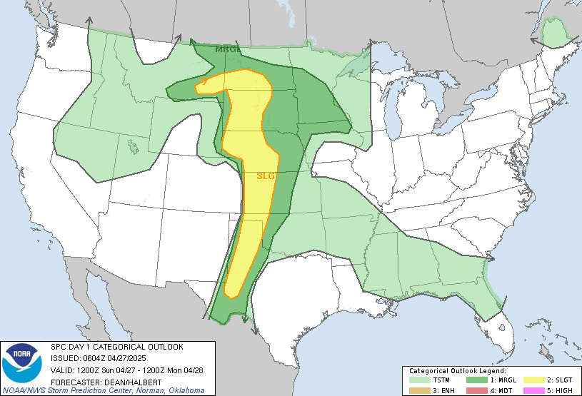


 DAY 1 CONVECTIVE OUTLOOK
 NWS STORM PREDICTION CENTER NORMAN OK 0100 AM CDT MON JUN 30 2014 VALID 301200Z - 011200Z ...THERE IS A MDT RISK OF SVR TSTMS ACROSS PORTIONS OF IA/MO/IL AND FAR SOUTHERN WI... ...THERE IS A SLGT RISK OF SVR TSTMS FROM THE SOUTH-CENTRAL PLAINS TO THE GREAT LAKES REGION... ...SUMMARY... WIDESPREAD SEVERE THUNDERSTORMS CAPABLE OF LARGE HAIL...TORNADOES...AND SWATHS OF WIND DAMAGE ARE EXPECTED ESPECIALLY THIS AFTERNOON INTO TONIGHT ACROSS MUCH OF THE CORN BELT AND MIDWEST. ADDITIONAL SEVERE STORMS WILL BE POSSIBLE ACROSS THE SOUTH-CENTRAL PLAINS. ...SYNOPSIS... THE LONGWAVE PATTERN WILL UNDERGO AMPLIFICATION DURING THE PERIOD TO THE NORTH OF A PERSISTENT UPPER RIDGE ACROSS THE SOUTHERN THIRD OF THE CONUS. IN PARTICULAR...A CLOSED LOW WILL MOVE SLOWLY EASTWARD OVER NORTHERN ONTARIO...WITH A SEASONALLY STRONG UPPER JET/AMPLIFYING SHORTWAVE TROUGH OVER THE NORTH-CENTRAL CONUS. AS A RESULT...HEIGHT FALLS AND INCREASINGLY STRONG CYCLONIC FLOW ALOFT WILL OVERSPREAD MUCH OF THE GREAT LAKES REGION/UPPER MIDWEST AND LOWER MO RIVER VALLEY THROUGH TONIGHT. A SOUTHEASTWARD-MOVING COLD FRONT ACROSS THE MIDDLE/LOWER MO VALLEY...UPPER MIDWEST...AND SOUTH-CENTRAL PLAINS WILL BE A GENERAL FOCUS FOR DEEP CONVECTIVE DEVELOPMENT AND ASSOCIATED SEVERE POTENTIAL. ...LOWER/MIDDLE MO VALLEY TO MIDWEST/UPPER GREAT LAKES... AS COMPARED TO SUNDAY...UPPER-LEVEL FORCING FOR ASCENT WILL BE MUCH MORE CONSEQUENTIAL /ESPECIALLY BY LATE JUNE STANDARDS/ AND MORE OPTIMALLY TIMED RELATIVE TO PEAK HEATING. IN THE PRESENCE OF A VERY MOIST AIR MASS AND ROBUST INSTABILITY...LARGE HAIL...TORNADOES...AND POTENTIALLY WIDESPREAD DAMAGING WINDS ARE EXPECTED ACROSS THE REGION LATER TODAY AND TONIGHT. EARLY DAY CONVECTION AND RELATED OUTFLOWS/CLOUD DEBRIS ONCE AGAIN ACCOUNT FOR SOME UNCERTAINTY RELATED TO SOME OF THE FORECAST DETAILS LATER TODAY. IN PARTICULAR...A REMNANT OVERNIGHT MCS COULD PERSIST EARLY TODAY ACROSS LOWER MI/NORTHERN INDIANA VICINITY...WHILE ADDITIONAL STORMS ARE LIKELY TO HAVE DEVELOPED ACROSS NEB/NORTHERN KS TO WESTERN IA THIS MORNING. ITS POSSIBLE THAT THESE STORMS ACROSS THE MIDDLE MO VALLEY COULD PERSIST/BECOME SURFACE-BASED DURING THE DAY UNDER THE INFLUENCE OF PERSISTENT WARM ADVECTION/DPVA. OF GREATER LIKELIHOOD MAY BE FOR THESE STORMS TO GENERALLY DECAY...WITH SUBSEQUENT SURFACE-BASED DEVELOPMENT DURING THE AFTERNOON AS HEIGHT FALLS OVERSPREAD THE REGION AND THE BOUNDARY LAYER AGGRESSIVELY DESTABILIZES. OF NOTE RELATED TO NUMERICAL GUIDANCE...THE 00Z NAM/GFS APPEAR TO BE OVERLY INFLUENCED BY CONVECTIVE FEEDBACK ACROSS IA INTO THE UPPER MS VALLEY/LAKE MI VICINITY. WHILE REAL-WORLD FEEDBACK IS INDEED POSSIBLE GIVEN STRONG DIABATIC HEATING/RICH MOISTURE...THE EXACT RAMIFICATIONS ARE UNCERTAIN...AND THE EXTREME DETAILS OF THESE PROGGED DOWNSTREAM INFLUENCES /ROBUST MAGNITUDE OF THE PROGGED LOW-LEVEL WIND FIELD ETC./ ARE PROBABLY AT LEAST SOMEWHAT OVERDONE. REGARDLESS...THE MOST PROBABLE SCENARIO IS FOR SURFACE-BASED STORMS TO DEVELOP/INTENSIFY THIS AFTERNOON...ESPECIALLY ACROSS IA/NORTHERN MO TO THE EAST OF AN ADVANCING SURFACE LOW AND NEAR THE SOUTHEASTWARD-MOVING COLD FRONT. GIVEN EARLIER EVENING /00Z/ OBSERVED REGIONAL RAOBS...A VERY MOIST AIR MASS WITH LOWER TO MIDDLE 70S SURFACE DEWPOINTS ARE EXPECTED TO PREVAIL WITHIN THE NEARBY WARM SECTOR. THIS WILL LIKELY CONTRIBUTE TO VERY STRONG DESTABILIZATION...IN THE ABSENCE OF OUTFLOWS AND LINGERING THICK CLOUD COVER...WITH AS MUCH AS 4000-5500 J/KG OF MLCAPE EXPECTED FROM KS INTO IA/NORTHERN MO AND IL. ROBUST INSTABILITY IN THE PRESENCE OF 40+ KT OF EFFECTIVE SHEAR WILL SUPPORT INTENSE SUPERCELLS AS THE INITIAL STORM MODE WITH A RISK OF VERY LARGE HAIL AND SOME TORNADOES. THE TORNADO POTENTIAL WILL BE INFLUENCED BY DIURNALLY STRONG LOW-LEVEL WINDS/SRH...ESPECIALLY NEAR/EAST OF THE DEVELOPING SURFACE LOW. GIVEN RELATIVELY STRONG FORCING FOR EARLY SUMMER...AND THE INFLUENCE OF THE COLD FRONT...UPSCALE QUASI-LINEAR GROWTH IS LIKELY TO OCCUR BY EARLY/MID-EVENING. AS SUCH...A POTENTIALLY WIDESPREAD DAMAGING WIND THREAT COULD EVOLVE ACROSS PORTIONS OF IA AND NORTHERN MO INTO IL/SOUTHERN WI AND POSSIBLE LOWER MI/NORTHERN INDIANA DURING THE EVENING/OVERNIGHT HOURS. ...SOUTH-CENTRAL PLAINS... STRONG WARM SECTOR HEATING/FRONTAL UPLIFT SHOULD OVERCOME WARM MID-LEVEL TEMPERATURES/CAPPING WITH ISOLATED TO WIDELY SCATTERED STRONG TO SEVERE THUNDERSTORM DEVELOPMENT EXPECTED BY LATE AFTERNOON/EARLY EVENING. THE REGION WILL GENERALLY BE SOUTH OF THE STRONGER WESTERLIES ALOFT...BUT AROUND 30 KT OF EFFECTIVE SHEAR AND MODERATE TO STRONG BUOYANCY /NEAR THE FRONT AND DRYLINE/ WILL ALLOW FOR SUSTAINED/ORGANIZED MULTICELLS AND POSSIBLY A FEW SUPERCELLS. LARGE HAIL AND LOCALLY DAMAGING WINDS WILL BE THE PRIMARY HAZARDS. ...SOUTHERN APPALACHIANS/SOUTHEAST STATES... WHILE VERTICAL SHEAR/OVERALL FORCING WILL BE WEAK...SUFFICIENT LOW-LEVEL LAPSE RATES AND BUOYANCY MAY EXIST FOR PULSE-TYPE STORMS CAPABLE OF MICROBURSTS THIS AFTERNOON.
dimanche 29 juin 2014
European Storm Forecast Experiment
Storm Forecast
Storm Forecast
Valid: Sun 29 Jun 2014 06:00 to Mon 30 Jun 2014 06:00 UTC
Issued: Sun 29 Jun 2014 04:22
Forecaster: VAN DER VELDE
Valid: Sun 29 Jun 2014 06:00 to Mon 30 Jun 2014 06:00 UTC
Issued: Sun 29 Jun 2014 04:22
Forecaster: VAN DER VELDE
A level 2 was issued for N Italy mainly for severe convective wind gusts, large hail and excessive convective precipitation.
A level 1 was issued for parts of central Europe mainly for large hail.
SYNOPSIS
The cold front associated with a large amplitude mid level trough from Scandinavia to the Mediterranean Sea is pushing eastward through Italy and central Europe today. Surface level lows reside over southern Scandinavia and northern Italy. Cold airmass thunderstorms are likely over France, Benelux and western Germany. The prefrontal airmass over Italy is moderately unstable due to the presence of the Saharan Air Layer with steep mid level lapse rates and 10-12 g/kg moist boundary layer air. Strong winds in mid levels create a favorable kinematic environment for storms.
TORNADO WARNING....NATIONAL WEATHER SERVICE DES MOINES IA
.A TORNADO WARNING REMAINS IN EFFECT UNTIL 845 PM CDT FOR WEST
CENTRAL SHELBY COUNTY...

AT 814 PM CDT...A CONFIRMED TORNADO WAS LOCATED NEAR EARLING...OR 21
MILES SOUTH OF DENISON...MOVING EAST AT 30 MPH.

HAZARD...DAMAGING TORNADO.

SOURCE...WEATHER SPOTTERS CONFIRMED TORNADO.
TORNADO WARNING FOR...
  NORTHEASTERN ANDREW COUNTY IN NORTHWEST MISSOURI...
  SOUTHEASTERN NODAWAY COUNTY IN NORTHWEST MISSOURI...

* UNTIL 830 PM CDT

* AT 758 PM CDT...A SEVERE THUNDERSTORM CAPABLE OF PRODUCING A
  TORNADO WAS LOCATED 11 MILES NORTHEAST OF FILLMORE...AND MOVING
  EAST AT 15 MPH.

  HAZARD...TORNADO AND HALF DOLLAR SIZE HAIL.
Tornado,,,,,2 miles W of PORTSMOUTH, IA
2014-06-30 01:02:00 UTC
multiple vorticies coming
out of wall cloud dancing on
ground, 4 miles to my north east, now
multiple vorticies coming
out of wall cloud dancing on
ground, 4 miles to my north east, now
Tornado,,,,,,,,, miles ESE of TENNANT, IA
2014-06-29 23:18:00 UTC
Long slender needle funnel
3/4 way to ground with debris. has
lifted. approx 5 to NW
Long slender needle funnel
3/4 way to ground with debris. has
lifted. approx 5 to NW
NWS Topeka, KS
 *PLEASE SHARE* with family and friends who live in the area. Scattered severe storms are possible late this afternoon and evening. Areas shaded in red will see the highest chances for severe weather with storms capable of very large hail, damaging winds in excess of 60 mph, and localized flooding. An isolated tornado or two cannot be ruled out. Another round of severe storms is once again possible for much of northeast Kansas tomorrow afternoon. Stay tuned to forecast updates later today.
NWS Omaha/Valley, NE
 Severe weather is expected to return to much of the area today, with very large hail, damaging winds and even a tornado or two all possible. Although severe storms with large hail are possible later this morning into early afternoon, severe weather chances will increase by mid afternoon as temperatures warm into the 80s. In addition to the severe weather threat, any storm could contain very heavy rainfall, although the heaviest rain was not likely to focus on any one particular location. If the activity forms into a larger complex late this afternoon through early evening the main weather threat could shift to damaging winds and heavy rain and then possibly shift southeast of the region. However, conditions are favorable for renewed development late tonight into Monday morning with heavy rain and severe thunderstorms remaining a possibility, especially across southeast sections, into Monday afternoon.
NWS Des Moines, IA
 Significant severe weather is possible both today and Monday over a large part of our forecast area. Both days we may see some tornadoes...very large hail...and widespread damaging winds. There will also be the potential for locally heavy rainfall today and Monday. Monday may also bring a widespread significant wind event to the area in the late morning and afternoon to evening hours. Be prepared...stay alert to changing conditions today and Monday. Monitor forecasts for possible watches and warnings. Review your severe weather safety procedures and move to a place of safety if a warning is issued for your area.
NWS Kansas City/Pleasant Hill, MO
 Several rounds of severe thunderstorms are possible through Monday afternoon. The first round is expected this afternoon through this evening with storms developing in the vicinity of far northwestern Missouri. These storms may initially be supercells with large hail, damaging winds and a few tornadoes possible. As storms evolve with time, the hazards will become mainly damaging winds and large hail. Additional severe storms are possible Monday afternoon through the overnight hours. Large hail and damaging winds are the main hazards. Additionally, flash flooding is possible both days as storms will produce copious amounts of rainfall on a localized scale.
Jun 29, 2014 0600 UTC Day 1 Convective Outlook,,,,,,,,,,,,,,,Public Severe Weather Outlook (PWO)
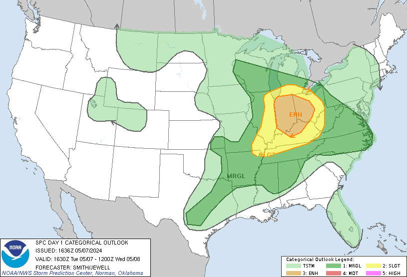


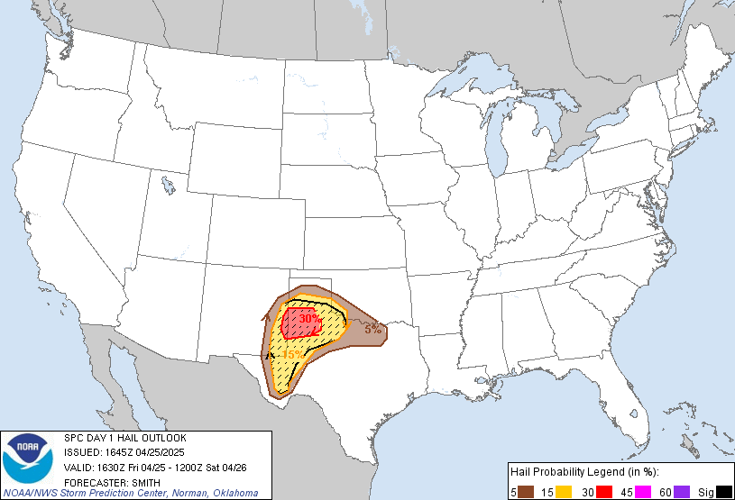 DAY 1 CONVECTIVE OUTLOOK
 NWS STORM PREDICTION CENTER NORMAN OK 1129 AM CDT SUN JUN 29 2014 VALID 291630Z - 301200Z ...THERE IS A MDT RISK OF SVR TSTMS OVER PARTS OF NEB...KS...IA...AND MO... ...THERE IS A SLGT RISK OF SVR TSTMS SURROUNDING THE MODERATE RISK AREA FROM THE CNTRL PLNS INTO THE MID MS VLY... ...THERE IS A SLGT RISK OF SVR TSTMS OVER PARTS OF THE UPR MS VLY... ...SUMMARY... SEVERE THUNDERSTORMS CAPABLE OF VERY LARGE HAIL...A FEW TORNADOES...AND SWATHS OF DAMAGING WIND ARE POSSIBLE THIS AFTERNOON AND TONIGHT OVER PARTS OF THE CENTRAL PLAINS AND THE MID AND UPPER MISSISSIPPI VALLEYS. ...SYNOPTIC SETUP... SEASONABLY STRONG WLY FLOW WILL PREVAIL THIS PERIOD FROM THE PACIFIC NW TO THE NRN PLNS/UPR MS VLY ON SRN SIDE OF NEARLY STNRY VORTEX OVER SRN MB. LEAD SHORTWAVE IMPULSE WITH THIS VORTEX...NOW OVER ERN WI...WILL CONTINUE ENE ACROSS MI LATER TODAY...FOLLOWED BY A WEAKER/SMALLER UPSTREAM DISTURBANCE NOW OVER CNTRL MN. FARTHER SW...SATELLITE INDICATES A POSSIBLE LOW-AMPLITUDE FEATURE NOW OVER WRN NEB THAT SHOULD CONTINUE ESE INTO THE LWR MO/MID MS VLYS BY EVE. AT THE SFC...MAIN COLD FRONT WITH MB SYSTEM ATTM ARCS FROM N CNTRL MN S AND SW THROUGH CNTRL NEB INTO THE CNTRL HIGH PLNS. THE FRONT SHOULD ADVANCE STEADILY E ACROSS THE UPR MS VLY TODAY...WHILE THE SRN PART BECOMES STNRY OVER NEB AS A WEAK LEE LOW FORMS TNGT/EARLY MON ALONG EXISTING LEE TROUGH OVER NE CO/NW KS. ...CNTRL PLNS INTO MID/UPR MS VLYS TODAY THROUGH TNGT... OVERALL SETUP OVER THIS REGION DURING THE NEXT 24 HRS WILL BE SUPPORTIVE OF MULTIPLE EPISODES/AREAS OF STRONG TO SVR TSTMS...WITH CONDITIONAL RISKS FOR VERY LARGE HAIL...DMGG WIND...AND TORNADOES. THE PATTERN WILL...HOWEVER...REMAIN COMPLICATED BY /1/ PRESENCE OF EXISTING CONVECTION AND /2/ THE FACT THAT UPR-LVL FORCING FOR ASCENT WILL BE SOMEWHAT FRACTURED AND/OR POSSIBLY NOT OPTIMALLY LOCATED/TIMED WITH RESPECT TO AREAS OF STRONGEST LOW-LVL CONVERGENCE. GIVEN THE CONTINUED WEAKENING OF SCTD ON-GOING TSTMS...IT APPEARS THAT POCKETS OF STRONG INSTABILITY /SBCAPE AOA 4000 J PER KG/ SHOULD DEVELOP WITH SFC HEATING FROM S CNTRL NEB SWD INTO CNTRL/WRN KS...AND FROM ERN NEB ESEWD INTO PARTS OF IA...ERN KS...AND NW MO. LARGE-SCALE FORCING FOR ASCENT ACROSS THE REGION WILL BE WEAK...WITH OVERALL HEIGHT RISES OCCURRING IN WAKE OF UPR MS TROUGH. THESE RISES WILL...HOWEVER...BE SOMEWHAT COUNTERACTED BY UPLIFT ASSOCIATED WITH DISTURBANCE NOW OVER WRN NEB. IF SUSTAINED STORMS DO FORM...AND THIS SEEMS MORE LIKELY THAN NOT...40-50 KT WNWLY DEEP SHEAR ON SRN FRINGE OF MB LOW WILL BE FAVORABLE FOR SUPERCELLS. COUPLED WITH RICH MOISTURE AND STEEP LOW TO MID-LVL LAPSE RATES...THESE COULD YIELD LARGE HAIL/DMGG WIND. TORNADOES ALSO MAY OCCUR...ESPECIALLY LATE THIS AFTN AND EARLY TNGT WITH STORMS MOVING ALONG OUTFLOW BOUNDARY SEGMENTS LEFT BY EARLIER STORMS. GIVEN THE STRENGTH OF SHEAR/BUOYANCY...AND THE LIKELIHOOD FOR MULTIPLE AREAS OF STORM GENERATION...SOME POTENTIAL WILL EXIST FOR UPSCALE DEVELOPMENT INTO MCSS. THESE COULD CONTAIN FOREWARD-PROPAGATING/BOWING SEGMENTS WITH DMGG WIND...ALTHOUGH EXPECTED FRACTURED NATURE OF LOW-LVL INSTABILITY FIELD LOWERS CONFIDENCE FOR ANY LONG-LIVED DERECHOS. ADDITIONAL ROUNDS OF STORMS...SOME WITH SVR HAIL AND POSSIBLY WIND...MAY OCCUR LATE TNGT THROUGH EARLY MON OVER PARTS OF NEB AND NRN KS...WHERE MOIST/SLY LLJ WILL STRENGTHEN E OF LEE LOW IN RESPONSE TO AN ADDITIONAL UPSTREAM DISTURBANCE IN WLY FLOW ALOFT. IN THE UPR MS VLY...A SEPARATE AREA OF STRONG TO SVR STORMS MAY EVOLVE WITH SFC HEATING THIS AFTN AHEAD OF MN UPR IMPULSE. DEEP SHEAR AND FORCING FOR ASCENT WILL BE STRONGER RELATIVE TO POINTS SOUTH...AND MID-LVL TEMPS WILL REMAIN COMPARATIVELY COOL. THE BOUNDARY LAYER...HOWEVER...BY COMPARISON WILL BE SOMEWHAT COOLER/DRIER. NEVERTHELESS...GIVEN 50 KT WSWLY DEEP SHEAR AND CONVERGENT LOW-LVL FLOW ALONG/AHEAD OF MN COLD FRONT...A CONDITIONAL RISK WILL EXIST FOR A FEW STORMS/POSSIBLE SUPERCELLS WITH SVR HAIL/WIND AND POSSIBLY A TORNADO ENE INTO THE MN ARROWHEAD...WI...AND PERHAPS WRN UPR MI.. ...SRN HIGH PLNS LATE THIS AFTN AND EVE... STRONG SFC HEATING ALONG DRY LINE/LEE TROUGH SHOULD FOSTER ISOLD TO WDLY SCTD HIGH-BASED TSTMS THIS AFTN/EVE...DESPITE ABSENCE OF ANY IDENTIFIABLE FEATURE TO ENHANCE LARGE-SCALE FORCING FOR ASCENT. DEEP/WELL-MIXED SUBCLOUD LAYER BENEATH 800-1500 J/KG MLCAPE COULD SUPPORT STG/ISOLD SVR GUSTS AND HAIL BEFORE STORMS WEAKEN WITH NOCTURNAL INCREASE IN CIN. ...ERN LWR MI...OH/TN VALLEYS THIS AFTN... LARGE-SCALE ASCENT ACCOMPANYING LEAD UPR IMPULSE WILL CONTINUE TO SUPPORT AN ARC OF DIURNALLY-ENHANCED STORMS OVER ERN LWR MI TODAY...WHERE WIND PROFILES APPEARS SUFFICIENT FOR SOME DEGREE OF STORM ORGANIZATION/SUSTENANCE AND PERHAPS A FEW INSTANCES OF LOCALLY DMGG WIND. FARTHER S...RELATIVELY WEAK CINH AND LIFT ALONG EXISTING OUTFLOW/DIFFERENTIAL-HEATING BOUNDARIES SHOULD PROMOTE SCTD TSTM CLUSTERS SWD INTO THE OH AND TN VLYS. MULTICELLULAR STORMS MAY YIELD A FEW DMGG GUSTS AND POSSIBLY MARGINALLY SVR HAIL.
European Storm Forecast Experiment
Storm Forecast
Storm Forecast
Valid: Sun 29 Jun 2014 06:00 to Wed 30 Jul 2014 06:00 UTC
Issued: Sun 29 Jun 2014 04:22
Forecaster: VAN DER VELDE
Valid: Sun 29 Jun 2014 06:00 to Wed 30 Jul 2014 06:00 UTC
Issued: Sun 29 Jun 2014 04:22
Forecaster: VAN DER VELDE
A level 2 was issued for N Italy mainly for severe convective wind gusts, large hail and excessive convective precipitation.
A level 1 was issued for parts of central Europe mainly for large hail.
SYNOPSIS
The cold front associated with a large amplitude mid level trough from Scandinavia to the Mediterranean Sea is pushing eastward through Italy and central Europe today. Surface level lows reside over southern Scandinavia and northern Italy. Cold airmass thunderstorms are likely over France, Benelux and western Germany. The prefrontal airmass over Italy is moderately unstable due to the presence of the Saharan Air Layer with steep mid level lapse rates and 10-12 g/kg moist boundary layer air. Strong winds in mid levels create a favorable kinematic environment for storms.
DISCUSSION
...Italy, southern Austria and western Balkan...
Some regional WRF models predict over 2500 J/kg SBCAPE over the Lgurian Sea. MLCAPE should be 1000-2000 J/kg. This will be capped south of the Po valley. Either way, given the 20 m/s deep layer shear and strong moisture lifting over the south slopes of the Alps triggering of supercells and MCSes is highly probable, with chances of widespread large to very large hail and severe wind gusts. During the evening as the cold front comes through, the model scenario (GFS, WRF) is that some discrete supercells or a linear system will also affect the area south of the Po valley. The area of Austria to Croatia will likely see the strongest moisture lift and largest storms, and can become affected by excessive convective rainfall, at least locally. The PV/dynamic tropopause intrusion acquires a negative tilt at night which might help to keep the storms active for long in the region near Slovenia, although WRF models keep the storms moving. Tornadoes are not ruled out with pre-Alpine 0-1 km shear of 8 m/s and locally higher.
...Hungary, N and E Austria, Czechia, Slovakia, Poland, Lithuania...
Relatively modest MLCAPE should exist in a broad area from Hungary/Austria to the Baltics. The presence of 10-15 m/s deep layer shear could develop persistent and rotating updrafts which can locally release large hail. The frontal convergence zone in the Austrian-Hungarian-Czechian borders region should be the main focus for convective development, another is NE Poland and Lithuania near the occlusion.
...southern Sweden and Norway...
Some instability is present within the low. Low cloud bases and slow cell motion combined with good low-level buoyancy and convergence zones are found mainly over southern Sweden. Such conditions are favorable for spout type tornadoes and funnels.
samedi 28 juin 2014
Inscription à :
Commentaires (Atom)





 StormScapeLIVE.TV,,,on a warned Tornado cell


