mercredi 18 septembre 2013
Sep 18, 2013 0600 UTC Day 1 Convective Outlook
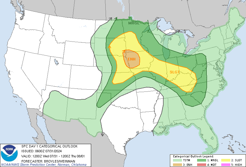
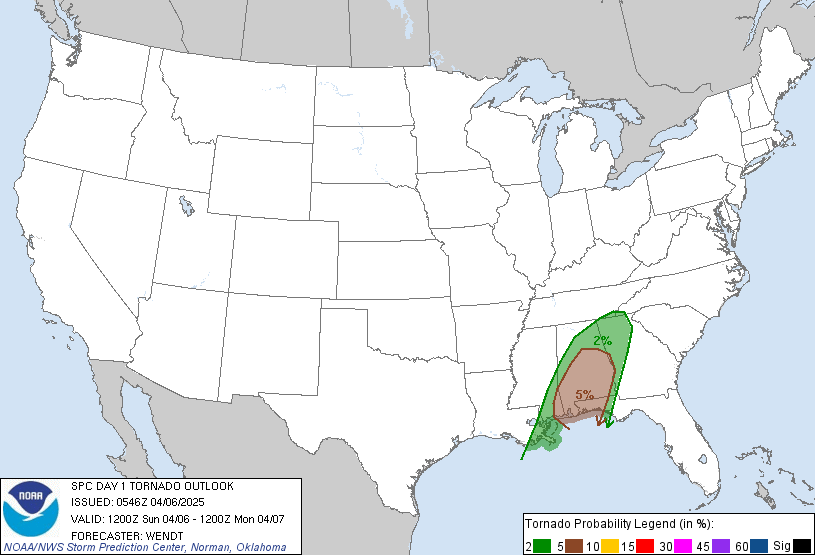
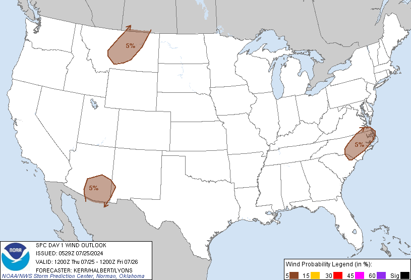
 DAY 1 CONVECTIVE OUTLOOK
 NWS STORM PREDICTION CENTER NORMAN OK 1245 AM CDT WED SEP 18 2013 VALID 181200Z - 191200Z ...THERE IS A SLGT RISK OF SVR TSTMS FOR THE NRN PLAINS... ...SYNOPSIS... UPPER AIR ANALYSIS AND WV IMAGERY SHOWED A SHORTWAVE TROUGH LOCATED OVER THE PAC NW EARLY THIS MORNING...WITH 70 M MIDLEVEL HEIGHT FALLS OCCURRING OVER THE NRN ROCKIES. THIS TROUGH IS FORECAST TO MOVE EWD INTO THE NRN HIGH PLAINS BY AFTERNOON...AND THEN BEGIN LIFTING NEWD TOWARD THE CANADIAN PRAIRIE PROVINCES DURING THE NIGHT. AS THIS TAKES PLACE...40-50 KT MIDLEVEL JET...AND 70+ KT UPPER-LEVEL JET WILL SPREAD NEWD FROM THE CNTRL ROCKIES INTO THE NRN PLAINS. AT THE SURFACE...LOW PRESSURE IS CURRENTLY BEGINNING TO CONSOLIDATE OVER ERN MT/WRN ND...WITH FURTHER DEEPENING EXPECTED TO TAKE PLACE LATER TODAY AS THE LOW ADVANCES ENEWD ACROSS ND. A WARM FRONT EXTENDING SEWD FROM WRN ND INTO THE CNTRL PLAINS THIS MORNING WILL MOVE EWD ACROSS ND WITH THE AREA OF SURFACE LOW PRESSURE. MEANWHILE...AS THE UPPER TROUGH CATCHES UP WITH THE LOW-LEVEL CYCLONE...A COLD FRONT WILL PROGRESS INTO THE WRN DAKOTAS BY AFTERNOON...AND ENTER WRN MN BY THE END OF THE FORECAST PERIOD. ...NRN PLAINS... MID TO LOCALLY UPPER 60S DEWPOINTS OVER THE CNTRL PLAINS ARE FORECAST TO ADVECT NWD INTO ND BY AFTERNOON IN RESPONSE TO A SURFACE CYCLONE PROGRESSING ENEWD ACROSS THE NRN PLAINS. STEEP MIDLEVEL LAPSE RATES OVERSPREADING THE MOIST LAYER COMBINED WITH TEMPERATURES IN THE LOW TO MID 80S WILL YIELD MLCAPE VALUES FROM 2000-3000 J/KG. WARM LAYER NEAR 800 MB WILL ACT TO CAP SURFACE BASED THUNDERSTORM DEVELOPMENT THROUGH EARLY AFTERNOON...BUT LARGE-SCALE ASCENT ASSOCIATED WITH THE APPROACHING TROUGH AND INCREASING LOW-LEVEL CONVERGENCE INVOF THE SURFACE LOW AND COLD FRONT WILL SUPPORT SCATTERED THUNDERSTORM DEVELOPMENT FROM MID AFTERNOON INTO THE NIGHT. BACKED SURFACE WINDS AHEAD OF THE SURFACE LOW AND ALONG THE WARM FRONT SURMOUNTED BY 30 KT LLJ...AND 40 KT MIDLEVEL SWLYS WILL FAVOR SUPERCELLS AND A THREAT FOR LARGE HAIL. ENHANCED LOW-LEVEL SHEAR NEAR THE WARM FRONT WILL PROMOTE A RISK FOR AN ISOLATED TORNADO OR TWO AS WELL. HOWEVER...MODERATELY STRONG MIDLEVEL SWLYS MAY ADVECT STORMS INTO A COOLER MORE STABLE BOUNDARY LAYER AIRMASS RATHER QUICKLY...WHICH WOULD PRECLUDE A MORE SUBSTANTIAL THREAT. AS THE UPPER TROUGH AND SURFACE COLD FRONT CONTINUE TO ADVANCE EWD INTO THE AREA AFTER DARK...STORM MERGERS WILL RESULT IN UPSCALE GROWTH WITH AT LEAST AN ISOLATED SEVERE WEATHER THREAT PERSISTING INTO WRN/NRN MN. ...CNTRL SD INTO NERN CO... ISOLATED HIGH BASED THUNDERSTORMS ARE FORECAST TO DEVELOP OVER THE CNTRL HIGH PLAINS THIS AFTERNOON ALONG AND AHEAD OF A SURFACE COLD FRONT. LOW-LEVEL SWLY WINDS WILL PROMOTE STRONG BOUNDARY LAYER MIXING WITH TEMPERATURES IN THE MID TO UPPER 80S AND DEWPOINTS IN THE 40S TO LOW 50S. AS A RESULT...MLCAPE VALUES WILL REMAIN NEAR 500 J/KG DESPITE THE PRESENCE OF STEEP MIDLEVEL LAPSE RATES. A COUPLE OF SEVERE STORMS WILL BE POSSIBLE...MAINLY IN THE FORM OF DAMAGING WINDS...DUE TO THE PRESENCE OF INVERTED-V BOUNDARY LAYER PROFILES AND DEEP-LAYER SHEAR UP TO 30 KT. ADDITIONAL ISOLATED STORMS MAY ALSO DEVELOP ALONG A PSEUDO DRYLINE BOUNDARY EXTENDING SWD FROM CNTRL SD INTO CNTRL NEB. DEWPOINTS HERE WILL BE IN THE LOW 60S...WHICH WILL YIELD MODERATE TO STRONG CAPE VALUES. SSWLY LOW-LEVEL WINDS VEERING TO WSWLY IN THE MIDLEVELS MAY SUPPORT BRIEF STORM ORGANIZATION AND A THREAT FOR LARGE HAIL.
European Storm Forecast Experiment
Storm Forecast
Storm Forecast
Valid: Wed 18 Sep 2013 06:00 to Thu 19 Sep 2013 06:00 UTC
Issued: Wed 18 Sep 2013 06:49
Forecaster: PUCIK
Valid: Wed 18 Sep 2013 06:00 to Thu 19 Sep 2013 06:00 UTC
Issued: Wed 18 Sep 2013 06:49
Forecaster: PUCIK
No threat levels have been issued.
SYNOPSIS and DISCUSSION
Between a ridge over the southern part of Atlantic / Iberia and a deep negatively tilted trough stretching from the Norwegian Sea towards Central Europe, broad northwesterly flow will impact much of Europe in the mid to upper troposphere. It is forecast that southern base of the trough will detach, forming a separate cyclonic vortex, heading towards Southern Ukraine / Black Sea. Speaking of DMC ingredients, this forecast period will generally feature a lack of overlap between low level moisture and steep mid-level lapse rates, perhaps apart from three locations: Northern Africa, Southeastern Spain and the Black Sea. Even here, lack of more significant vertical wind shear will preclude chances for severe DMC, so that no Levels are introduced atm.
dimanche 15 septembre 2013
European Storm Forecast Experiment
Storm Forecast
Storm Forecast
Valid: Sun 15 Sep 2013 06:00 to Mon 16 Sep 2013 06:00 UTC
Issued: Sun 15 Sep 2013 10:20
Forecaster: PUCIK
Valid: Sun 15 Sep 2013 06:00 to Mon 16 Sep 2013 06:00 UTC
Issued: Sun 15 Sep 2013 10:20
Forecaster: PUCIK
A level 2 was issued for Sicily and Southwestern Italy mainly for excessive precipitation, tornadoes, severe wind gusts and large hail.
A level 1 was issued for Sardegna, Corsica and Western Italy mainly for excessive precipitation and to the lesser degree for tornadoes and severe wind gusts.
A level 1 was issued for North Tunisia mainly for large hail and severe wind gusts.
SYNOPSIS
Upon a brief glance on the satellite imagery loops, one might easily notice three main features on the synoptic scale. The first one being a large and deep cyclonic vortex residing over the Northern Atlantic, moving steadily southeastwards. More to the south, a prominent short-wave trough has just crossed Southern France and is heading for Italy. And finally, towards the east, decaying cyclonic vortex is centered over Southern Ukraine. Generally speaking, no major overlap of sufficient low level moisture and steep lapse rates is forecast over much of Europe - therefore, continental part is not going to see any DMC activity during this forecast period. On the other hand, western Mediterranean, under the influence of the short-wave trough, will likely see widespread activity especially during the overnight hours.
samedi 14 septembre 2013
jeudi 12 septembre 2013
Sep 12, 2013 0600 UTC Day 1 Convective Outlook


 DAY 1 CONVECTIVE OUTLOOK
 NWS STORM PREDICTION CENTER NORMAN OK 1230 AM CDT THU SEP 12 2013 VALID 121200Z - 131200Z ...THERE IS A SLGT RISK OF SVR TSTMS FOR PARTS OF THE NORTHEAST... ...SYNOPSIS... A PAIR OF MID-LEVEL VORTICITY MAXIMA WILL AID IN THE AMPLIFICATION OF A LARGER-SCALE TROUGH ACROSS SERN CANADA/NERN CONUS INTO EARLY FRI. THE LEAD IMPULSE OVER THE UPPER GREAT LAKES WILL MOVE EWD ACROSS ONTARIO/QUEBEC...DAMPENING SOMEWHAT AS THE UPSTREAM IMPULSE OVER MANITOBA DIGS SEWD ACROSS THE GREAT LAKES. AT THE SURFACE...COLD FRONTS WILL ACCOMPANY EACH VORTICITY MAXIMA WITH THE STRONGER SURGE OCCURRING WITH THE LATTER IMPULSE. ...NORTHEAST... ISOLATED DAMAGING WIND/SEVERE HAIL AND PERHAPS A TORNADO APPEARS MOST PROBABLE ACROSS NRN NEW ENGLAND TODAY GIVEN A 30-40 KT SWLY LLJ. ISOLATED DAMAGING WIND SHOULD BE THE PRIMARY THREAT FARTHER TO THE S/SW WHERE DEEP-LAYER FLOW IS WEAKER. SCATTERED SHOWERS AND ISOLATED STORMS WILL LIKELY BE ONGOING THIS MORNING IN ASSOCIATION WITH THE AFOREMENTIONED LEAD SHORTWAVE IMPULSE AND FRONTAL ZONE. THIS CONVECTION ALONG WITH EXTENSIVE OVERTURNING SINCE WED AFTERNOON SHOULD SERVE TO LIMIT INSTABILITY COMPARED TO YESTERDAY. THE TRACK OF THE LEAD IMPULSE WILL RESULT IN STRONG DEEP-LAYER SHEAR LARGELY REMAINING CONFINED IN THE WARM SECTOR TO NRN NEW ENGLAND. BUT WITH WIDESPREAD MIDDLE 60S TO LOWER 70S SURFACE DEW POINTS...DIURNAL HEATING /MORE PRONOUNCED WITH SRN EXTENT/ SHOULD YIELD WEAK TO MODERATE BUOYANCY WITH MLCAPE INCREASING TO 750-1500 J/KG BY EARLY AFTERNOON. THIS SHOULD BE CONCOMITANT WITH STORMS INCREASING IN COVERAGE WITH THE POSSIBILITY OF ORGANIZED LINE SEGMENTS AND EMBEDDED SUPERCELLS TO THE NE AND SEMI-ORGANIZED BROKEN BANDS TO THE SW. ...OH VALLEY... A MARGINAL RISK FOR LOCALLY DAMAGING WIND/SEVERE HAIL IS EXPECTED THIS AFTERNOON AND EVENING. STRONG SURFACE HEATING IS ANTICIPATED ALONG/AHEAD OF AN INITIAL COLD FRONT NEAR THE OH RIVER...YIELDING MODERATE BUOYANCY WITH MLCAPE LIKELY REACHING 1000-2000 J/KG S OF THE RIVER. CONVECTION SHOULD INITIALLY FORM ALONG THIS BOUNDARY AND DEVELOP SEWD WITHIN MODEST NWLY STEERING FLOW. MUCH STRONGER DEEP-LAYER NWLYS WILL ACCOMPANY A SECONDARY FRONTAL SURGE IN ASSOCIATION WITH THE SHORTWAVE TROUGH DIGGING TOWARDS THE GREAT LAKES. ALTHOUGH LOW-LEVEL MOISTURE MAY BE SCANT FOR DEEP CONVECTION...STRONG FORCING FOR ASCENT/SHEAR COULD YIELD MARGINAL SEVERE WITH ISOLATED STORMS ALONG THE LATTER COLD FRONT.
European Storm Forecast Experiment
Storm Forecast
Storm Forecast
Valid: Thu 12 Sep 2013 06:00 to Fri 13 Sep 2013 06:00 UTC
Issued: Wed 11 Sep 2013 21:45
Forecaster: GATZEN
Valid: Thu 12 Sep 2013 06:00 to Fri 13 Sep 2013 06:00 UTC
Issued: Wed 11 Sep 2013 21:45
Forecaster: GATZEN
A level 2 was issued for central Serbia mainly for large hail, severe wind gusts, and tornadoes.
A level 1 was issued for the central Balkans and western Romania mainly for large hail, severe wind gusts, tornadoes, and excessive precipitation.
A level 1 was issued for the western Ukraine and Romania mainly for large hail.
A level 1 was isued for the Adriatic region mainly for large hail, axcessive precipitation, severe wind gusts, and tornadoes.
A level 1 was issued for the north African coasts and the south Mediterranean mainly for large hail and severe wind gusts.
SYNOPSIS
Main synoptic-scale feature is a broad cut-off low slowly digging south-east from central Germany to northern Austria. Two main vort-maxima will travel with this trough. The first is associated with a rather intense short-wave trough that moves across the central Mediterranean and Adriatic before it becomes negatively tilted and moves on into the Balkans and Poland. The second is connected to the cut-off center and slowly spreads across southern Germany and the Alps into the Adriatic. Cold air advection will set in at the western and southern flank of the cut-off, spreading across most of the western and central Mediterranean. Further east, warmer air masses with better moisture will remain from the southern Adriatic into the central Balkans and Black Sea region. This moisture may overlap with increasing lapse rates ahead of the trough axes. Over northern Europe, ridging is expected ahead of a new Atlantic trough.
mercredi 11 septembre 2013
mardi 10 septembre 2013
Convective Outlooks
| Today's Outlook | |
 | |
| This is tomorrow's forecast for organized severe thunderstorms over the contiguous United States. Please read the description of the risk categories for further information. The latest Day 2 Outlook is available as well as all Outlooks that have been issued today. | Tomorrow's Outlook |
 | |
| This is the day after tomorrow's (day 3) forecast for organized severe thunderstorms over the contiguous United States. Please read the description of the risk categories for further information. The latest Day 3 Outlook is available as well as all Outlooks that have been issued today. Note: The 10% and greater probability thunder line is not included on the Day 3 Outlook. | Day 3 Outlook |
 |
Sep 10, 2013 0600 UTC Day 1 Convective Outlook


 DAY 1 CONVECTIVE OUTLOOK
 NWS STORM PREDICTION CENTER NORMAN OK 1145 PM CDT MON SEP 09 2013 VALID 101200Z - 111200Z ...THERE IS A SLGT RISK OF SVR TSTMS ACROSS PORTIONS OF THE NORTHEAST STATES... ...SYNOPSIS... A MID-LEVEL SHORTWAVE IMPULSE WILL MINOR OUT WITHIN CONFLUENT FLOW WHILE TRACKING FROM LAKE SUPERIOR AND ADJACENT ONTARIO INTO CNTRL/SRN QUEBEC. STRONG MID-LEVEL WSWLY FLOW ACCOMPANYING THIS DISTURBANCE WILL GLANCE THE UPPER GREAT LAKES REGION AND NEW ENGLAND...WHILE A WSWLY LOW-LEVEL JET SPREADS EWD FROM THE GREAT LAKES. AS THIS OCCURS...SFC LOW PRESSURE WILL DEVELOP EWD FROM SRN ONTARIO AND SRN QUEBEC INTO NEW ENGLAND...WITH A FRONT TRAILING SW OF THE LOW INTO THE CNTRL HIGH PLAINS. MEANWHILE...AN UPSTREAM TROUGH IN THE MID LEVELS WILL AMPLIFY INTO THE SRN CANADIAN PRAIRIE PROVINCES...MAINTAINING MEAN CYCLONIC FLOW OVER THE NRN PLAINS AND UPPER MIDWEST. A BROAD ANTICYCLONE WILL REMAIN PROMINENT OVER THE SERN/S-CNTRL CONUS...WITH FLANKING WEAK CYCLONES OVER THE LOWER CO RIVER VALLEY AND OFF THE ERN COAST OF THE FL PENINSULA. ...PORTIONS OF THE NORTHEAST STATES TODAY INTO THIS EVENING... ONE OR MORE CLUSTERS OF STRONG TO PERHAPS LOCALLY SVR THUNDERSTORMS MAY BE ONGOING AT THE BEGINNING OF THE PERIOD OVER WRN/NRN NEW YORK. THIS WOULD BE IN RESPONSE TO PRECEDING UPSCALE CONVECTIVE GROWTH WITHIN THE TERMINUS OF A 35-40-KT LOW-LEVEL JET CROSSING THE ERN GREAT LAKES. RESIDUAL NOCTURNAL INHIBITION MAY SERVE TO LIMIT THE SVR POTENTIAL THIS MORNING. HOWEVER...ISOLATED SVR WIND CANNOT BE RULED OUT DOWNWIND OF LAKES ERIE AND ONTARIO THIS MORNING AS ISALLOBARIC FORCING DRIVES RICHER LOW-LEVEL MOISTURE NEWD ACROSS THE NERN STATES...AND 30-40 KT OF UNIDIRECTIONAL CLOUD-LAYER FLOW POTENTIALLY SUPPORTS THE CONTINUATION OF ORGANIZED CONVECTION. THROUGH THE DAY...STRONGER LOW-LEVEL ASCENT ACCOMPANYING THE LLJ MAY HAVE A TENDENCY TO OUTPACE THE NEWD-EXPANDING REGION OF HIGHER THETA-E AIR SE OF THE AFOREMENTIONED SFC LOW. AT THE SAME TIME...MID-LEVEL HEIGHTS ARE FORECAST TO GRADUALLY RISE IN THE WAKE OF EARLIER CONVECTION WHOSE REMNANT DEBRIS COULD STUNT APPRECIABLE BOUNDARY-LAYER DESTABILIZATION. HOWEVER...STEEP MID-LEVEL LAPSE RATES ACCOMPANYING THE INFLUX OF AN EML PLUME WILL OVERLIE INCREASINGLY RICH BOUNDARY-LAYER MOISTURE -- E.G. SFC DEWPOINTS INTO THE 60S TO PERHAPS AROUND 70F -- TO POTENTIALLY GENERATE LARGE CONVECTIVE INSTABILITY ACROSS THE SLIGHT-RISK AREA. LATER-DAY CONVECTIVE REDEVELOPMENT CANNOT BE RULED OUT INVOF RESIDUAL OUTFLOW BOUNDARIES/DIFFERENTIAL HEATING ZONES...AND STRONG VERTICAL SHEAR WILL AID IN A CONDITIONAL POTENTIAL FOR PRIMARILY SVR WIND/HAIL. ANY SUCH ACTIVITY WOULD HAVE A TENDENCY OF SPREADING EWD/ESEWD ACROSS PORTIONS OF NEW YORK AND NEW ENGLAND BEFORE BECOMING INTERRUPTED BY THE INFLUX OF A STABLE MARINE LAYER CLOSER TO THE COAST. HOWEVER...RELATIVELY WEAK ASCENT THROUGH A DEEP LAYER AND LARGE UNCERTAINTY IN THE EVOLUTION OF NOCTURNAL CONVECTION AND ITS ENSUING IMPACT ON BOUNDARY-LAYER STATIC STABILITY BREED LOW CONFIDENCE IN THE EVOLUTION OF LATER GENERATIONS OF CONVECTION...IF ANY. IN FACT...IT IS POSSIBLE THAT MUCH...IF NOT ALL...OF THE REGION WOULD BE VOID OF DIURNAL CONVECTIVE REDEVELOPMENT. ...SERN NEB AND ADJACENT FAR NRN KS NEWD INTO WI THIS AFTERNOON AND EVENING... LIFT EMANATING FROM VERTICAL CIRCULATIONS ALONG THE SWWD-EXTENDING FRONT WILL AUGMENT ASCENDING BRANCHES OF PBL CIRCULATIONS ON THE WARMER SIDE OF THE BOUNDARY TO PROMOTE ISOLATED TO WIDELY SCATTERED THUNDERSTORMS. INSTABILITY WILL BE RATHER MARGINAL...THOUGH THE PRESENCE OF 20-45 KT OF 500-MB FLOW -- HIGHEST NORTH -- SHOULD OFFER SUFFICIENT DEEP SHEAR FOR A FEW SUSTAINED CELLS WITH THE POTENTIAL FOR ISOLATED SVR WIND. DEEP FORCING FOR ASCENT AND LIMITED BUOYANCY WILL BE THE PRIMARY FACTORS TO INHIBIT THE OVERALL SVR POTENTIAL. ...PORTIONS OF THE SOUTHWEST STATES THIS AFTERNOON AND EVENING... SCATTERED CONVECTION WILL ONCE AGAIN FORM AROUND THE WEAK MID-LEVEL CYCLONE AMIDST RESIDUAL MONSOONAL MOISTURE. STRONG WIND GUSTS WILL BE POSSIBLE IN AREAS THAT EXPERIENCE STRONGER SFC HEATING/STEEPER LOW-LEVEL LAPSE RATES. AN ISOLATED MARGINALLY SVR WIND GUST CANNOT BE RULED OUT. HOWEVER...THE PRESENCE OF ONLY MODEST MID-LEVEL FLOW/DEEP SHEAR AND ONLY MODESTLY STEEP MID-LEVEL LAPSE RATES PRECLUDE THE DELINEATION OF SVR WIND PROBABILITIES AT THIS TIME.
dimanche 8 septembre 2013
samedi 7 septembre 2013
jeudi 5 septembre 2013
mercredi 4 septembre 2013
European Storm Forecast Experiment
Storm Forecast
Storm Forecast
Valid: Thu 05 Sep 2013 06:00 to Fri 06 Sep 2013 06:00 UTC
Issued: Wed 04 Sep 2013 21:51
Forecaster: GATZEN
Valid: Thu 05 Sep 2013 06:00 to Fri 06 Sep 2013 06:00 UTC
Issued: Wed 04 Sep 2013 21:51
Forecaster: GATZEN
A level 1 was issued for northern Algeria and Tunisia mainly for large hail.
A level 1 was issued for Sardinia and surroundings mainly for excessive rain.
A level 1 was issued for western central Spain mainly for large hail and severe wind gusts.
SYNOPSIS
The amplified trough over eastern Europe cuts of an forms a closed upper low centred across the north-eastern Ukraine. To its west and north, the Alpine mid-level high ridges into Scandinavia. Western Europe is affected by rather low geopotential. A trough centre is located over north-western Iberia and another cut-off process in underway over the British Isles. Additionally, a weak cut-off remains near Sardinia.
Best low-level moisture can be found in an easterly flow regime across the south Mediterranean with mixing ratios in excess of 13 g/kg. Rather good moisture is also present in the warm air mass that extends across west-central Europe. However, lapse rates are rather poor over most places except for the Iberian Peninsula and northern Africa.
mardi 3 septembre 2013
European Storm Forecast Experiment
Storm Forecast
Storm Forecast
Valid: Tue 03 Sep 2013 06:00 to Wed 04 Sep 2013 06:00 UTC
Issued: Mon 02 Sep 2013 14:44
Forecaster: PISTOTNIK
Valid: Tue 03 Sep 2013 06:00 to Wed 04 Sep 2013 06:00 UTC
Issued: Mon 02 Sep 2013 14:44
Forecaster: PISTOTNIK
A level 1 was issued for parts of Poland, Belarus and the Ukraine for severe wind gusts and tornadoes.
SYNOPSIS
A pronounced low-pressure system moves southeastward over Belarus and the Ukraine, with a jet streak that curves around its Western and Southern flank. Further upstream, a West-East aligned frontal zone establishes over the Atlantic to the North of the British Isles.
Much of Western, Central and Southern Europe will be under anticyclonic influence with seasonable temperatures, whereas a surge of cool air spreads southward in Eastern Europe. Poor lapse rates throughout Europe bring about a mostly calm day convection-wise.
Inscription à :
Commentaires (Atom)

